Part 1, Part 2, Part 3
This diary is the fourth of a seven-part series on Maine’s political geography. In this diary, I will discuss the two counties of Down East Maine: Hancock and Washington. These counties include the eastern parts of the Maine coast, and the ports here are downwind from Boston, hence the term ‘Down East’.
This is the smallest of the six regions of Maine that I am using for this series. The region contains only about 85,000 people, and has no major cities and large uninhabited inland areas. Nonetheless, it still has many interesting political trends.
Color code for the maps below (and for all other maps like this that I draw):
Darkest blue: 80%+ for Democrats
Dark blue: 70-79.99% for Democrats
Normal blue: 60-69.99% for Democrats
Lighter blue: 55-59.99% for Democrats
Lightest blue: 50-54.99% for Democrats
Yellow: No candidate received an absolute majority of votes
Pink: 50-54.99% for Republicans
Normal red: 55-59.99% for Republicans
Brown: 60-69.99% for Republicans
Dark red: 70-79.99% for Republicans
Darkest red: 80%+ for Republicans
Gray on the State Senate map represents towns won by independent candidates. White represents towns where no one voted. Green represents uninhabited townships.
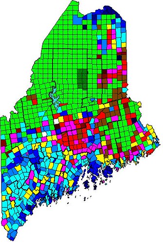
Here is a map of Obama’s performance by town in 2012:
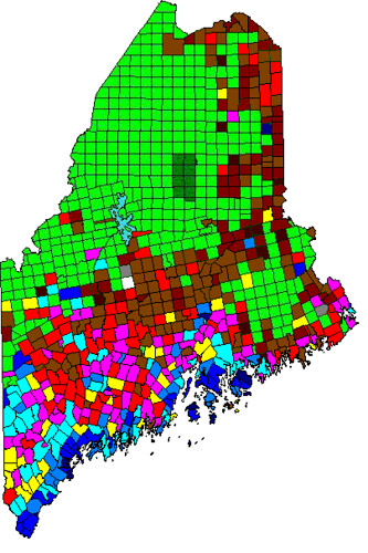
Here is a map of Maine’s Question 1 (gay marriage) in 2012:
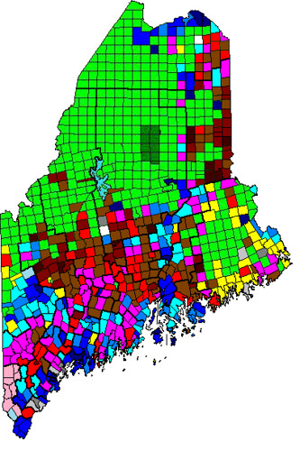
Here is a map of Maine’s State Senate results in 2012:
Follow me over the fold to begin… with Hancock County!
Hancock County
Hancock County is what a lot of non-Mainers think of when they think of Maine. Its small towns, lighthouses, rocky shoreline, islands, and of course Acadia National Park make Hancock County a big tourist destination. If the combination of coastal liberals, outdoor enthusiasts, and a college (the College of the Atlantic, in Bar Harbor) gives you the impression that Hancock is therefore a Democratic county, you would be correct. As a whole, Hancock County is solidly Democratic, however, as should not be surprising, Democratic strength is not evenly distributed throughout the county. Hancock County can be divided into three regions: the Western Mainland, consisting of Bucksport, Blue Hill, and everywhere in between; Central and Eastern Mainland, consisting of Ellsworth (the largest town and county seat) and all the mainland towns east of it; and the Islands, dominated by Mount Desert Island but also containing several smaller island groups.
The western part of Hancock County is a region of small rural towns, dominated by peninsulas large and small. The economy of this area is dominated by the surrounding ocean, either through fishing and lobstering (which is very big here) or through tourism, with visitors coming to see Castine (home to two forts, a lighthouse, and the Maine Maritime Academy) and Blue Hill, home to a large hill called, creatively, Blue Hill. Blue Hill has great views of the surrounding peninsulas and islands, as well as of the Camden Hills across Penobscot Bay (the reverse is also true; there is a great view of Blue Hill from the summit of the Camden Hills). The largest town in this region is Bucksport, which is also the northernmost town here. This region also includes Orland (which is just east of Bucksport), as well as Penobscot (which is NOT in Penobscot County), and Castine, all of which face the Penobscot River. The rest of the region includes Brooksville, Sedgwick, and Brooklin (which face south) and Blue Hill and Surry (which face east). The towns in this region are all solidly Democratic, with several of them voting in the mid-60s for Obama in 2012, and every town here voted at least 55% for Obama in 2012. There are no important differences in partisanship between these towns. Interestingly, a friend of mine who lives here told me that the lobstermen here were generally conservative, while the coastal liberals (who clearly outnumber the lobstermen) are, well, liberal.
The central and eastern parts of Hancock County are different from the western parts in several important ways. First, there are no big tourist attractions here. Also, most of the region faces the Mount Desert Narrows or Frenchman Bay as opposed to the Atlantic Ocean itself. Additionally, this area (except for Ellsworth and Trenton) is very remote. These factors result in this region having substantially fewer coastal liberals than the western part of the county, and thus the central and eastern areas are much less liberal. Ellsworth, the county seat of Hancock County, is the largest town here, and Ellsworth is generally politically moderate. It very narrowly voted for Obama last year, and many of the towns nearby, such as Trenton, Lamoine, and Hancock, voted similarly. The coastal parts of this region, including Gouldsboro and Winter Harbor, are generally all moderate, while the sparsely-populated inland areas are generally more conservative. However, since the inland areas here consist only of extremely tiny towns (<500 people) separated by uninhabited forests, the more-liberal parts of the county generally dominate in countywide politics.
Hancock County’s islands are by far the most populous of any of the islands off Maine’s coast. Mainely, this is due to Mount Desert Island. Mount Desert Island (MDI), home to most of Acadia National Park, consists of four towns: Bar Harbor, Mount Desert, Southwest Harbor, and Tremont. A majority of MDI’s population lives in Bar Harbor. Bar Harbor (whose pronunciation is sometimes spoofed as Bah Hahbah) is a strongly liberal town that is located on the eastern coast of MDI. It contains the College of the Atlantic (CoA), a liberal arts college with a focus on human ecology. CoA was one of the first colleges to go completely carbon neutral, and so, unsurprisingly, it has a liberal atmosphere. The other towns on MDI, Mount Desert, Southwest Harbor, and Tremont, are not quite as liberal as Bar Harbor but still lean strongly Democratic. These other towns are similar to western Hancock County in terms of partisanship and character. None of the other islands in Hancock County are anywhere near as populous as MDI. Deer Isle, which actually consists of two towns (Deer Isle and Stonington), is solidly liberal, as are the Cranberry Islands just south of MDI. Swans Island, located between Deer Isle and MDI, is more conservative, but tiny in population.
Hancock County, along with being solidly Democratic, is also socially liberal as well. It voted 53 percent for gay marriage in 2009, one of only four Maine counties to vote for gay marriage that year. In 2012, the county improved to 57 percent for gay marriage. As you might expect, the Bar Harbor area voted strongly for gay marriage, and most of the western part of the county (all except Bucksport, Orland, and Verona Island) also voted strongly for gay marriage. Bucksport and Orland, which are more blue-collar than their neighbors to the south, basically tied. Ellsworth narrowly voted for gay marriage, while the eastern coast of Hancock County was very close, and unsurprisingly the small inland towns voted strongly against gay marriage. Most of the trends we have seen in other coastal counties also occur here.
Hancock County contains one full State Senate district, about one-third of a second district, and a small portion of a third district. Here I will only talk about Hancock’s full State Senate district, the new 7th/old 28th. This district, despite its voting 59 percent for Obama in 2012, is represented by a Republican, Brian Langley of Ellsworth. In another example of community ties trumping partisanship, Langley won by a 51-49 margin in 2012 by racking up a 2-1 margin in Ellsworth along with large margins in nearby Hancock, Lamoine, and Trenton. His opponent, David White of Bar Harbor, did well on MDI and won all the western Hancock County towns, but his margins in them were not enough to erase Langley’s margin in Ellsworth. This district got a point more Republican in redistricting, mainly by adding some inland areas, but even so, the new district still voted 58% for Obama last year, and Langley’s narrow victory last year shows that he is still vulnerable. This district should be one of the Democrats’ top targets in 2014.
Washington County
Washington County is the easternmost county in Maine. It is one of Maine’s smallest counties in population, with only about 33,000 people. It is very rural, with only one town having more than 2,000 people. In both the 2008 and 2012 presidential elections, Washington County was the closest county in Maine, with Obama winning it by very narrow margins both times. The economy of Washington County is not based on tourism anywhere near as much as in Hancock County. Instead, agriculture plays a big role: 85 percent of the world’s wild blueberries are grown here, and one of my professors told me that every summer a bunch of Mexican farm workers descend on Washington County, and that during that time you can hear Spanish being spoken as much as English. Its large size, small population, and large uninhabited areas are not conducive to forming distinct regions, so rather than dividing the county into regions, I will briefly discuss some smaller areas.
The southwestern part of the county is a coastal area that leans Republican. Towns such as Cherryfield, Harrington, Columbia, Columbia Falls, and Addison are the largest base of Republican votes in the county. This area doesn’t get many tourists, and coastal “creative types” liberals are all but absent here. Moving east along the coast, we get to the Jonesboro/Jonesport area and then the Machias area, both of which are politically moderate. Machias is the county seat of Washington County, and it is home to a small branch of the University of Maine. Continuing our eastern trek, we arrive at one of the two Democratic bases of Washington County: the towns of Eastport and Lubec. These are the two easternmost towns in the continental United States, and Lubec is the location of West Quoddy Head, the absolute easternmost point in the continental U.S. These two towns get more tourists than the rest of the county, and because of their scenic beauty, distinctions as the easternmost towns in the U.S., and huge tides (as a result of their being right next to the Bay of Fundy), they attract the kind of people who are more likely to vote Democratic.
Moving north along the Canadian border, we get to Calais (pronounced ‘kallus’), the largest town in Washington County. That the largest town in Washington County has only 3,123 people shows just how rural it is. Calais itself is politically moderate, voting very narrowly for Obama. About equidistant from Calais, one southeast and one northwest, are the other Democratic base of Washington County: two Passamoquoddy Native American Reservations, one of which is called Pleasant Point (which is just north of Eastport), and the other of which is called Indian Township (which is just northwest of Princeton). These two reservations wouldn’t have much of a political impact in most other places, but in a small, closely-divided county, they can play a big role. Finally, the tiny towns north of Indian Township are Republican, not surprising since they are rural and in the middle of nowhere.
As should not be surprising from its rural nature and relative lack of coastal liberals, Washington County is socially conservative. It voted 65 percent against gay marriage in 2009, and in 2012 it still voted 59 percent against gay marriage. In 2012, every town except for Eastport and the two Native American reservations voted against gay marriage, and Calais, Lubec, and Roque Bluffs (a small town just south of Machias) were close. Who knew that Native Americans would be so supportive of gay marriage?
The new 6th/old 29th State Senate district contains all of Washington County as well as some adjoining parts of Hancock County and a tiny portion of Penobscot County. The reason why there is so much yellow on the State Senate map in this district is because there was a three-way race here in 2012. The winner was David Burns, a Republican from Perry, who received 43 percent of the vote. Anne Perry, a Democrat from Calais, received 38 percent, and an independent candidate received 19 percent. While this district gave Obama only 48.8 percent of the vote, the 2012 results suggest that Democrats may have an opening here, if our candidate can get most of the votes that went to the Independent. Also, this district improved three-quarters of a point in redistricting, so while this isn’t one of our top targets, we should certainly try to keep David Burns on his toes.
This concludes Part 4 of my series. In the next part, I will discuss Northwest Maine: Oxford, Franklin, and Somerset Counties.
I hope you enjoyed reading, and I welcome any feedback or questions!

