The first post-eruption SO2 measurements of 600 µg/m³ at Egilsstaðir were 2 1/2 times the previous Icelandic (pre-eruption) pollution record.
Then that was crushed when Reyðarfjörður hit 2600 µg/m³ - like breathing from a tailpipe.
Then that was crushed when Reyðarfjörður hit 4000 µg/m³.
Recently I expressed concern when the sensitive ecosystem of Mývatn started getting hit with pollution spikes. Yes, I was concerned then. But that was just just a trifle compared to what they've been getting now.
Mývatn, meet 5800 µg/m³.
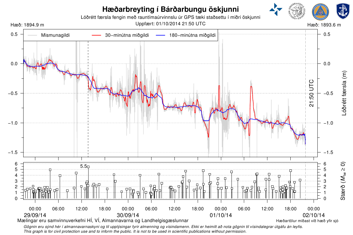
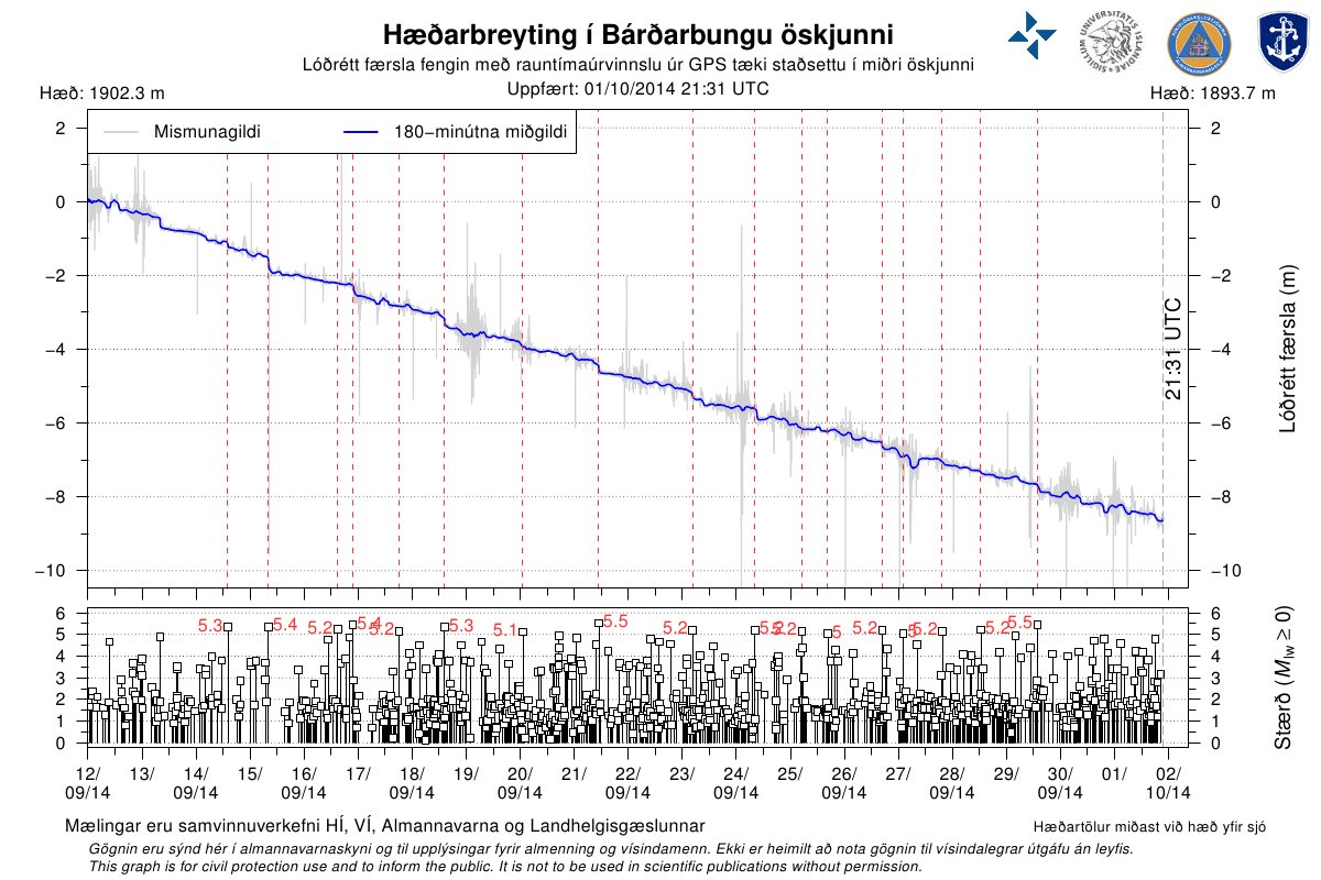
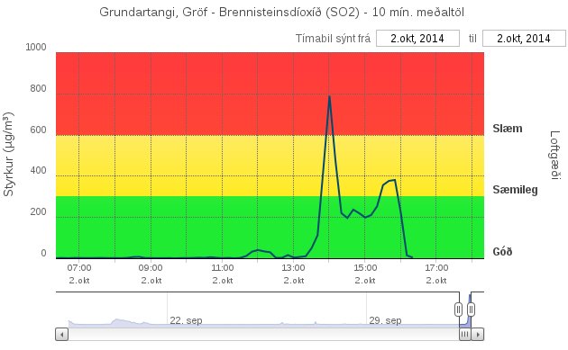
The graphs tell the story:

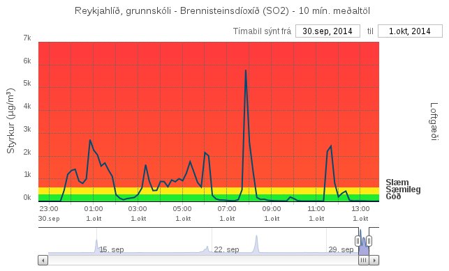
In the worst location, the elementary school at Reykjahlíð, the "healthy" and "poor" bands are confined to thin little strips at the bottom of the graph. They've given up reporting the exact measurements and are just listing the levels in the thousands.
A 5800 µg/m³ 10-minute measurement. Hours spent in the thousands. Just terrible, simply terrible.
To quote user northsylvania from the comments in the last article, "What happens in Iceland doesn't stay in Iceland":
Note when the animation resets how the new elevated "background" SO2 level that Bárðarbunga has built up disappears. Now picture what that would be like if this went on for a year. Or longer.
We know that breathing SO2 is bad for people. We know it's also very bad for plants. But just what is this stuff like in general? Well, first, let me show you a picture, from a farm just west of Egilsstaðir:
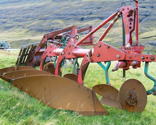
(Credit: Gunnar Jónsson / Austurfrétt)
Okay... so just a rusty old plow, right? Not exactly. It's a rusty new plow. This plow blade was mirror-shiny before the eruption started a month ago. Likewise...
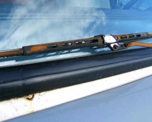
(Credit: Gunnar Jónsson / Austurfrétt)
Formerly-unrusted windshield wipers, likewise corroded in just a month - in cold temperatures and with no salt spray. Umhverfisstofnun (the Icelandic EPA) says that it's probable that what we're seeing is accelerated acid corrosion - not from acid rain, but from the mist itself.
This is what's going into peoples' lungs, eyes, etc.
Of course, all this probably isn't what you all were expecting to read about today. You probably have been wanting to know what's going on with the lava flow. Well, me too. New map:
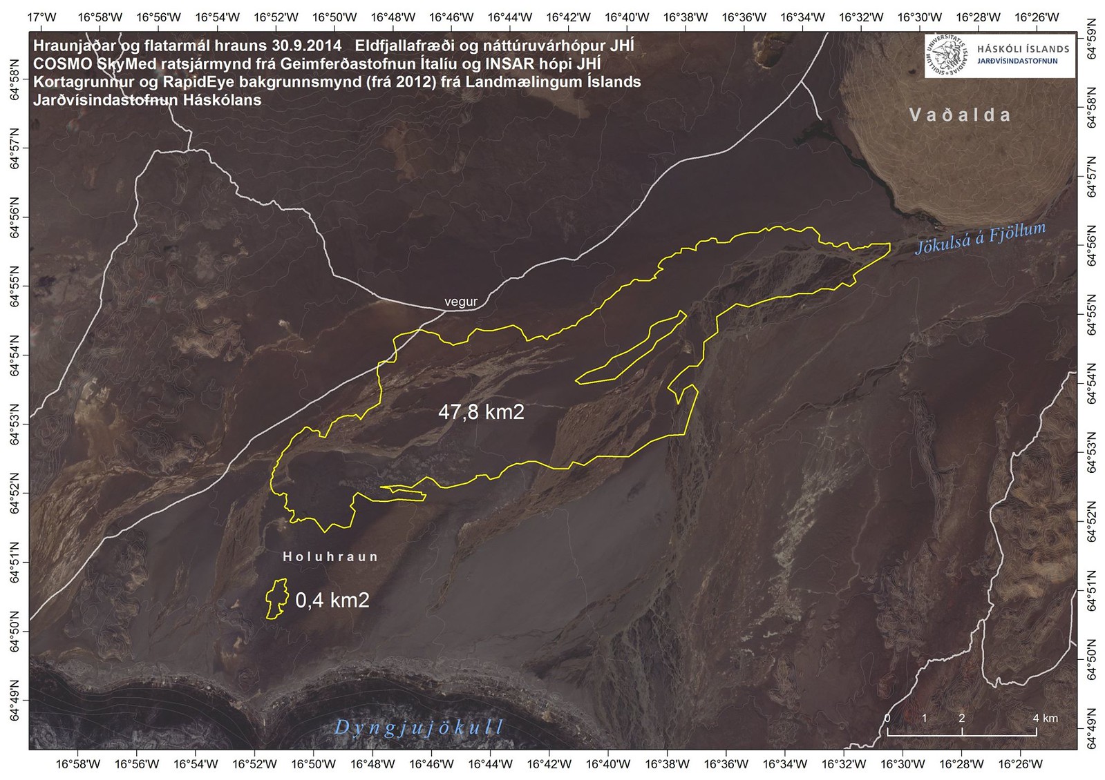
The flow has now reached 48,2 square kilometers. You can see the new flow on the southeast, which was so bright last night that people were mistaking it for a new vent.
You'll notice a little gap in the flow: that's because there's a series of small hills there:
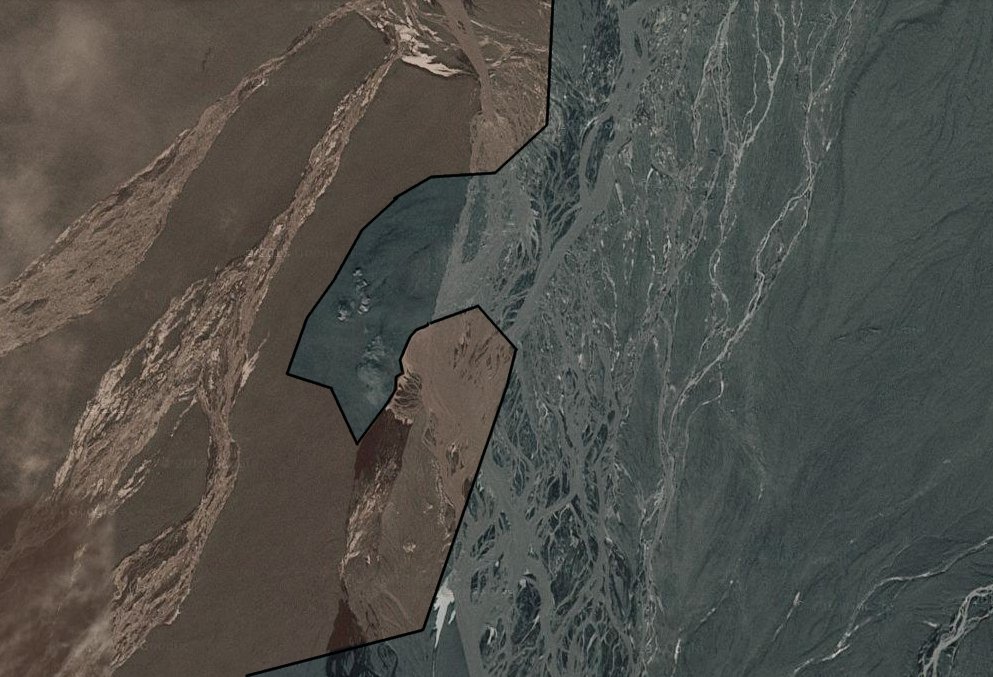
This cuts through the main channel of the river - and more than that, the flow has shoved the western channels into the main channel. So this was lots of lava meeting lots of water.
Of course, there's even more, deeper, more constrained water to the northeast. Is it still expanding in that direction? Míla says yes:
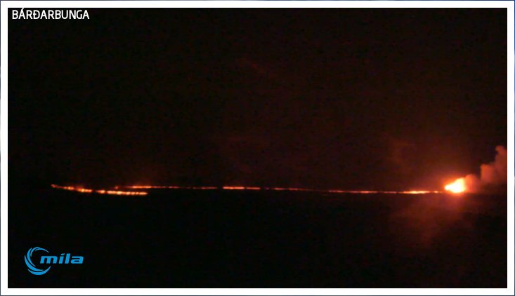
It is no longer so spectacular, but still visibly advancing. Will it change the degree of damming of the river in that direction? Time will tell. But there was a serious anomaly in the flow rates the other day:
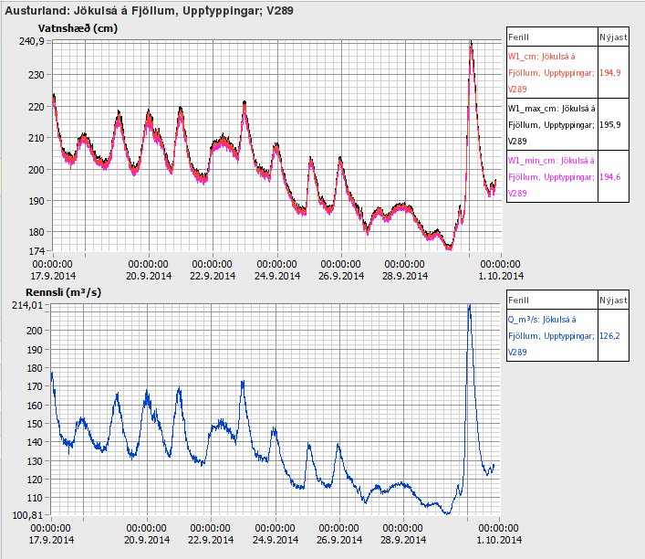
The flow rate of the river doubled in only four hours; a back of the envelope calculation suggests that it released around 1,5 million cubic meters of water over its normal level. Except for one detail: the scientific council's update didn't see it. "No changes are visible in the water measurements which are not possible to explain with weather changes."
Ed, 13:40: As per a very helpful comment below from Jobbi, he points out that there were some precipitation meters in the highlands that I missed which could explain it; I had checked the precipitation meter at Kárahnjúkar and found it broken, so checked the meters at Akureyri and Höfn further away, which showed relatively little precipitation). However, I'm satisfied after looking at the other meters that this explanation could account for the surge.
In other news: rumble rumble CRACK! rumble CRACK! CRACK! rumble CRACK! rumble rumble...
...rumble CRACK! rumble rumble CRACK! CRACK! rumble CRACK! rumble...
...CRACK! CRACK! rumble CRACK! rumble CRACK! CRACK! rumble CRACK!...
On the seismic front, AGU recently conducted their own interview with geophysicist Þorbjörg Ágústsdóttir, focused on her personal experiences on-site. She describes the excitement and tension of feeling earthquakes from a dike advancing toward her location at Askja, itself being an active volcano, and the 4,5 quake in Askja's caldera. She additionally goes a lot into the precautions that were taken on-site.
The AGU also released this video:
For a video with a bit more flash, this drone video sure gets some nice shots :)
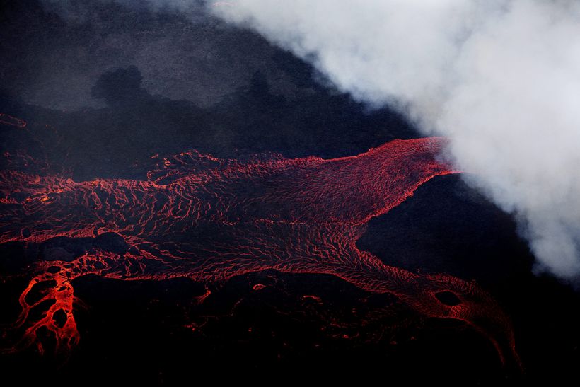
Let's add in a lava river pic, just to make clear what was dumping into the river last night. :)
(Credit: Ragnar Axelsson)
Update, 16:45: I had been planning to drive half an hour from my apartment to work on my land in the countryside in Hvalfjörður. Then I just checked the meter right across the fjörd:
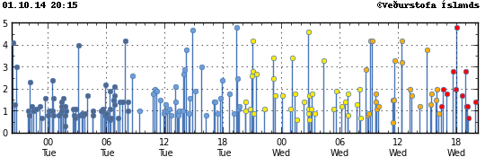
Given that these things come and go (as you can see with the Mývatn graphs), and I have no clue whether it's going to "come" again... would you go half an hour from home to exert yourself out in the open in such a circumstance? I'm still trying to decide. At least I have a mask I could go with. Maybe I'll just take the day off, I'm kind of tired anyway. Levels here in Reykjavík hit 150 µg/m³ at one point, but that's probably not significant to anyone who's not already in serious medical trouble unless it persists for long periods of time (WHO 5m limit = 500 µg/m³, 24h limit 20 µg/m³).
Update, 21:30: No new article this evening. Sorry!
