Winter is coming.
Fans of Game of Thrones probably know that the land beyond the Wall is, in real life, Iceland. Film crews are nothing new to us here; this scene was filmed only about 10 kilometers from my house at Þórufoss, short from where a drilling project recently struck the hot water that'll be used to heat my home. "The Mountain" is Icelandic strongman Hafþór Júlíus Björnsson, one of the world's strongest men.
For scenes of rugged, frigid-looking territory, the crews turned to the Mývatn area in lieu of computer generated imagery. But Holuhraun is deeper into the highlands and colder still. And now winter is coming, and the ice and the fire meet.
Join us below the fold for this snowy edition of Eldfjallavakt.
Those of you watching the eruption on the webcam have noticed the snowstorm that has been bearing against the cameras. Further away, it bears against the researchers and media as well. But still, they come.
(Credit: Kerstin Langenberger)
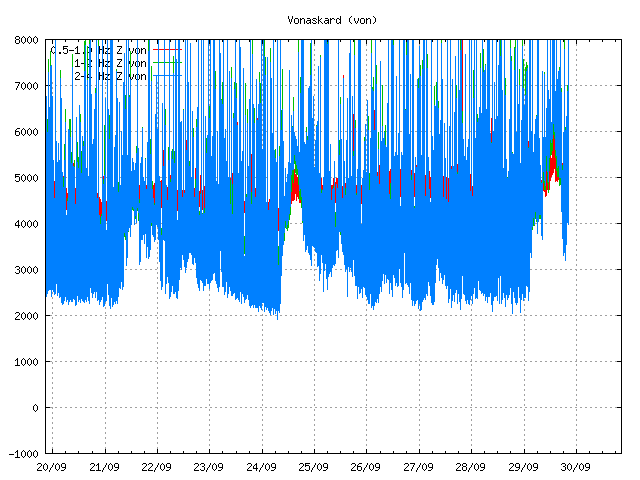
Some of you watching the meters may be think that either there's an eruption imminent:
Or contrariwise that the whole thing is calming down:
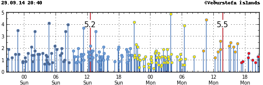
The answer is, neither. The storm is playing havoc on the tremor and quake meters. That said, the quake meters can still pick up the big ones, and that 5.5 we got sure was a big one, big enough to feel in Akureyri. There've only been four 5.5 quakes and one 5.7 in this whole event.
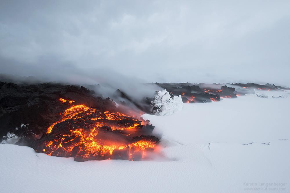
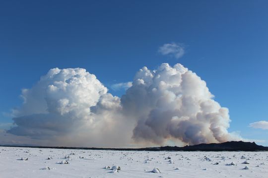
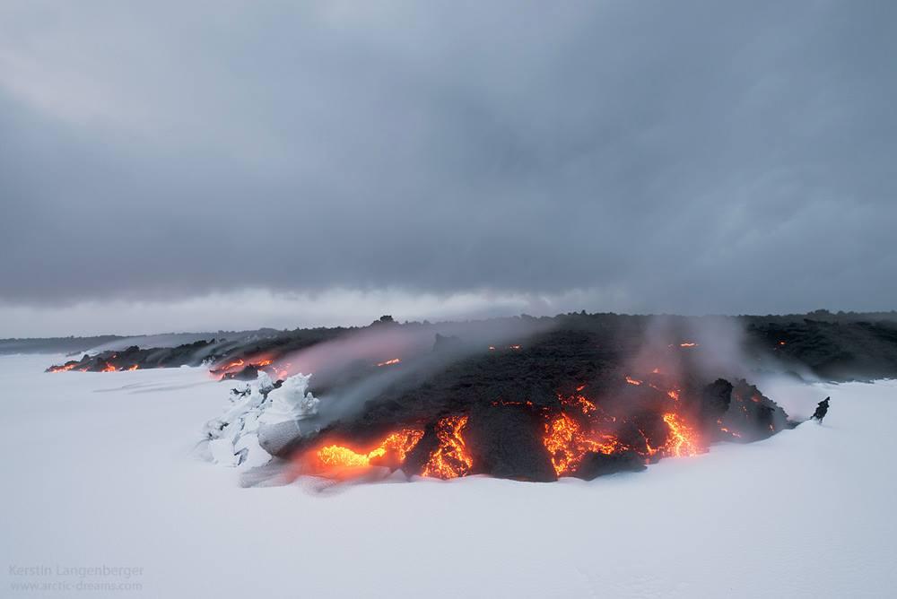
But let's take another look at that fire and ice:
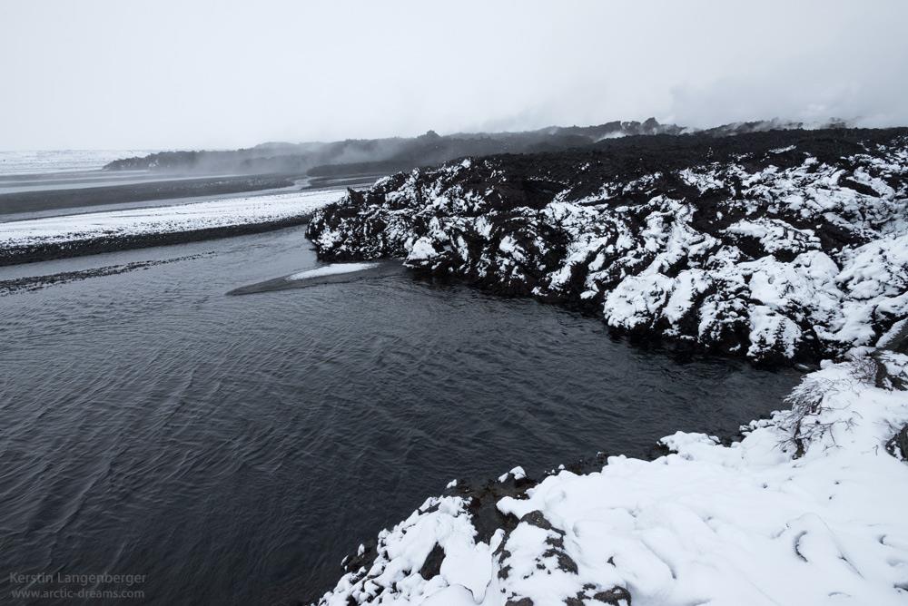
(Credit: Kerstin Langenberger)
We can see that the snow provides a convenient trick: it shows us where the lava is still hot and where it has cooled. Given the presence of the river on the west, one cool lava flow, and one hot but not glowing flow, we can assume that the photographer was standing near the first tongue near Vaðalda and looking at the second tongue that came to its south afterwards.
One commenter on the page of the Geosciences Center, Ásta Þorleifsdóttir, states that the water coming out from underneath the lava flow on Friday measured at 47C and was usable as a footbath.
The storm is making mapping out just what's happening with the flow difficult. But once again, infrared saves the day:
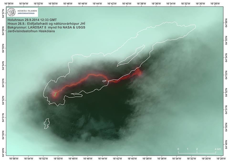
(Credit: Jarðvísindastofnun)
So we can see that the road-destroying north flow is no longer being fed by a lava river and thus will no longer advance further quickly, if at all. The southern flow, however, is now going full force toward the proto-lake. I don't know what will happen when it gets there. I suspect it's not going to be enough to fully dam things up, and that it'll probably just constrain it tighter toward the eastern bank, changing the formerly braided river into a strong single channel full of rapids. But that's just my limited-information speculation. The flow area is stated to be over 44 square kilometers.
"There's still an unbelievable amount of power in the eruption," says Ármann Höskuldsson, commenting on the occasion of the 1 month anniversary of the eruption. He points out that not only are there extremely deep quakes under Bárðarbunga, but also under Dyngjujökull and Holuhraun, suggesting that "it's not all coming straight from Bárðarbunga, but rather from deeper." Commenting about how most of the eruptive power has consolidated into Baugur, he says that was expected and added that "There's basically nothing unusual about this eruption except the magnitude of what it's producing."
In another article, he searches for comparisons. "A great and powerful flow up to the surface and a great deal of gas are the characteristics of this eruption. It is something that we have never seen before in connection with a comparable eruption. Rather, we've never seen a comparable eruption. It's a much bigger eruption than we've we've seen in the 19th and 20th century. We have to back up to the Laki eruption to find something comparable." He had only expected the eruption to last 10 days and has been surprised by its continuing power.
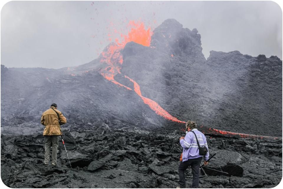
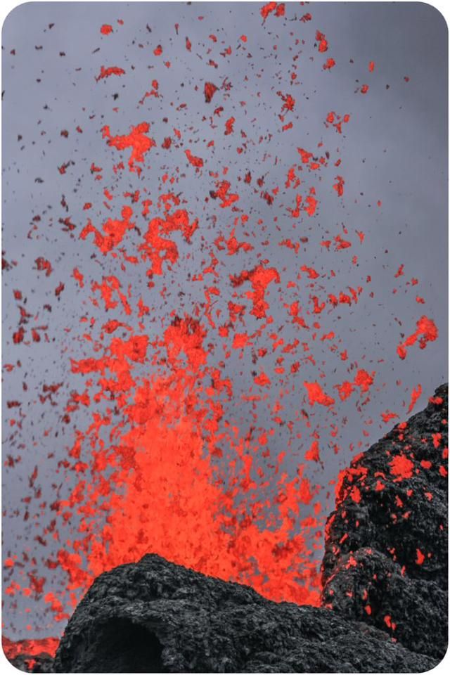
But as always... back to that pretty lava. Has anyone wanted to be the first to climb those newly-formed mountains?
Too bad, a couple of photojournalists and their guide beat you to the punch:
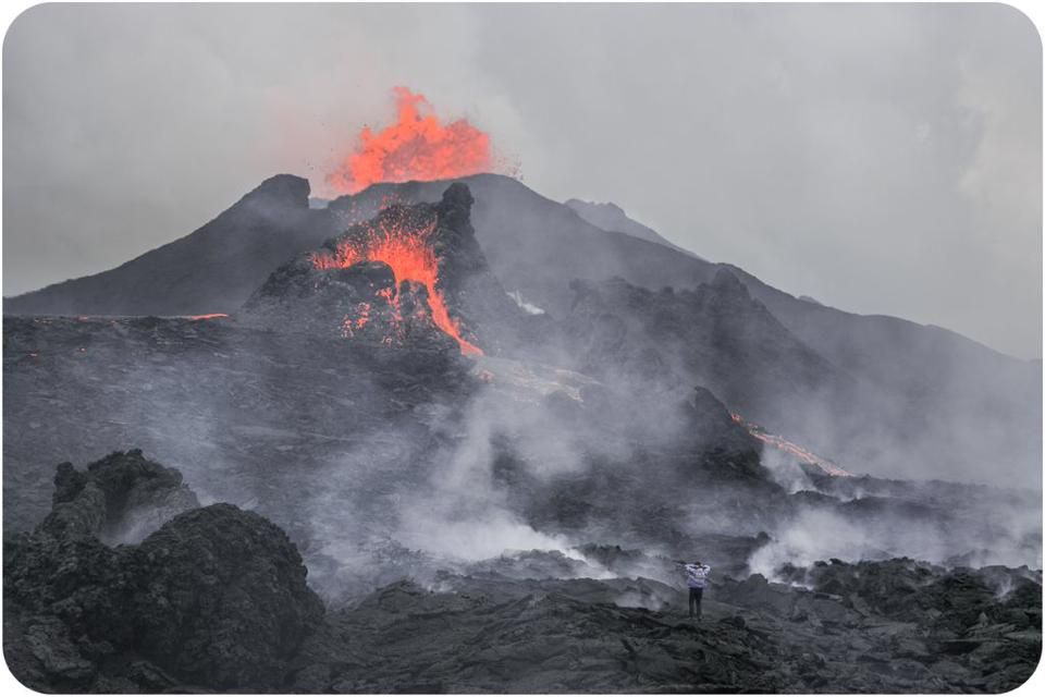
(Credit: Stefán Gunnar Svavarsson)
The team was professional credentialed volcano photographers who have done nothing for the past 25 years but photograph erupting volcanoes. To pull it off during their week at the site, they not only had to have gas masks, but even oxygen tanks, as the gas plume emissions are so high. As our Kilauea-exploring members are familiar with, the ground was often hot enough to ignite their shoes if they stood too long in a single place.
Overall, their experience seems more like exploring an alien planet than anything Captain Kirk ever did.
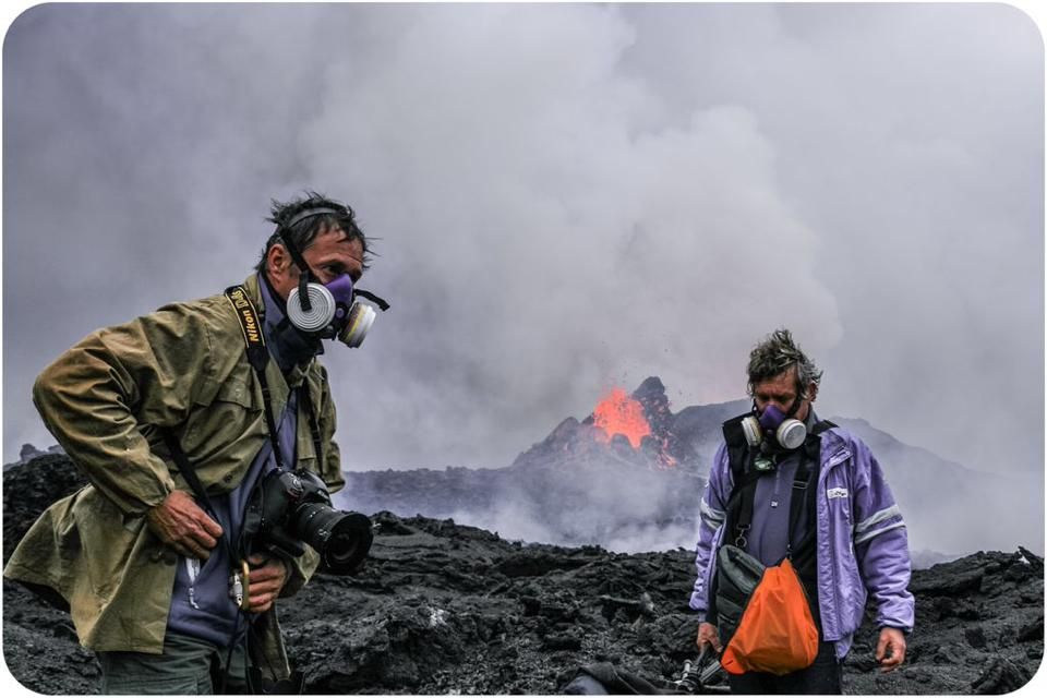
(Credit: Stefán Gunnar Svavarsson)
As for the gas, this recently published picture shows a phenomenon that some of you may have noticed before: the stratification of the volcanic plume:
(Credit: Morten S. Riishuus)
You can see the heavier sulfur dioxide dropping out and hugging the ground as Mist while the lighter steam rises up. Those of you watching the Akureyri cam during their moderate (550 µg/m³) pollution event today likely noticed the faint Mist rolling down along the contours of the landscape into town. That's not to say that the two gases fully separate; the Mist still contains water, and the water clouds still contain SO2.
What should people in Akureyri who want a gas mask do? Get in line. Not only are gas masks sold out all across Iceland, but there's a waiting list - even after all this time. Demand clearly continues to outpace expectations. Here's a news report (in Icelandic) on it:
Time for a few pictures:
(Credit: Kerstin Langenberger)
(Credit: Stefán Gunnar Svavarsson)
(Credit: Stefán Gunnar Svavarsson)
Plus one special picture that I received in my inbox today....
(Credit: You!)
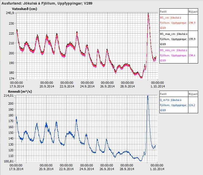
Update, 11:15: "Something" happened on the river last night - in four hours (9 PM to 1 AM) the meter at Upptyppingar jumped from 112 m³/s to 214 m³/s and the water height from 184 to 241 cm. That's a surplus of 1 1/2 million cubic meters of water (400 million gallons), the volume of a cube 114 meters on each side. I can't explain this with weather - normally when the weather gets cold flow rates become lower and steadier. And temperatures were below freezing the whole time. But maybe there's some weather explanation I'm not seeing. Otherwise, it looks like a flow pattern change due to the advancing lava flow, as if a good chunk of the "lake" drained out. Either that or a little jökulhlaup.
Hopefully we'll get a clarification soon.
Update, 9:15: The lava is clearly pouring into the lake, with such a significant reaction visible on the Míla cameras that you could mistake it for a second vent. Still, I'm unable to get any information at this time about the details of the interaction. I think I'm going to delay tonight's article until tomorrow so I can get some better info and pictures. For now, here's a graph of the water flow spike: