The new finding was published 1-21-15 in the Proceedings of the National Academy of Sciences (PNAS). According to scientists, rivers of melt water are draining Greenland quicker and contributing to sea level rise more than all the other processes that drain melt water from the glaciers combined. As a South Floridian I find this news to be very scary stuff!
Eighty percent of Greenland, which is about the size of the United States west of the Rocky Mountains, is covered by ice, which has the potential to make a significant contribution to sea level rise as it melts.
Because Greenland's ice sheet is vast and difficult to study from ground level, scientists are still learning about the many processes by which its melting water reaches the ocean. This is the first study of the drainage system of rivers and streams that forms atop the ice sheet in summer.The new paper is based on research that took place on the ice sheet itself, carried out by lead author Laurence Smith of UCLA, JPL's Behar and nine other researchers in July 2012, and on remote sensing data from the same period. The researchers traveled by helicopter to map the network of rivers and streams over about 2,000 square miles (5,600 square kilometers) of Greenland. They were especially interested in learning how much of the meltwater remained within the ice sheet and how much drained to the ocean.
Virtually all of the flowing water drains directly to the ocean through sinkholes, the researchers found.
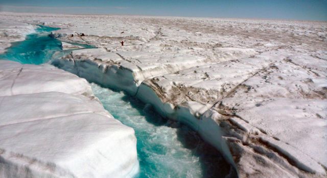 A river of meltwater flowing across Greenland's ice sheet. Image credit: UCLA/Laurence C. Smith
Larger Image
A river of meltwater flowing across Greenland's ice sheet. Image credit: UCLA/Laurence C. Smith
Larger Image
From the study.
Meltwater runoff from the Greenland ice sheet (GrIS) accounts for half or more of its total mass loss to the global ocean (1, 2) but remains one of the least-studied hydrologicprocesses on Earth. Each summer, a complex system of supraglacial meltwater ponds, lakes, streams, rivers, and moulins develops across large areas of the southwestern GrIS surface, especially below ∼1,300 m elevation (3–7), with supraglacial erosion driven by thermal and radiative processes (5). Digital elevation models (DEMs) suggest a poorly drained surface resulting from abundant topographic depressions, which computational flow routing models must artificially “fill” to allow hydrological flow paths extending from the ice sheet interior to its edge (8–11). The realism of such modeled flow paths remains largely untested by real-world observations. To date, most observational studies of GrIS supraglacial hydrology have focused on large lakes (∼1 km2) because of their good visibility in commonly available optical satellite images (6,12–15). Lakes have also attracted considerable scientific interest because some of them can abruptly drain, rapidly transferring water from the supraglacial to the subglacial system, triggering transient ice uplift and velocity changes (16–20). Greenland’slarge supraglacial channels (Fig. 1), however, have received much less study, despite their acknowledged role as a transport mechanism for meltwater and their linkage to englacial/subglacial systems via moulins, crevasses, and shear fractures (21, 22). Reasons for this include difficulties in remote sensing of narrow supraglacialchannels (22) and lack of in situ hydraulic data because of challenging field conditions in the ablation zone, where a rapidly lowering ice surface, abundant flowing water, anddangerously fast currents limit mobility and instrument installations. For these reasons, large supraglacial streams are not well characterized, and their overall drainage pattern, storage capacity, discharge, and comparative importance as a GrISsupraglacial runoff mechanism are unknown. In turn, this knowledge gap impedes process-level understanding of ice sheet mass losses from meltwater runoff, which have accelerated since 2000 (2, 23) and are expected to rise further in the future.
We are in BIG trouble. Jim Inhofe and other Republicans (as well as some Democrats) will help to kill us all. I say this not because of sea level rise which will be catastrophic enough, (we can relocate our coastal population centers in theory anyways), but because the explosive Methane release in the arctic could be devastating to all life on the planet.

