Sunday began orange according to the air quality index, but when it turned to yellow I agreed to go for a walk with my daughter and her dog. Most of the past month I’ve been stuck indoors with the windows closed. We began a few miles away, at 2,800 feet elevation near a small lake/reservoir, and strolled along a flume that brings water to the lake. The air looked clear and the sky was pale blue. It wasn’t the deep blue I expect from a mild day in late summer, but neither was it the wildfire smoke scummy white we’ve had in the best of times during the past month. I had attempted to check the air quality at De Sabla, but there’s no monitoring data for that area. It looked safe enough (see above photo). But I awoke the following morning feeling breathless.
Air Quality Index (AQI)
 For more explanation of the categories click here.
The trail follows the flume up a nearly imperceptible gain in altitude, just enough to keep the water flowing to the reservoir from the source many miles upstream. The flumes were created to support mining activities in the late 1800s, often dug by Chinese laborers who were paid half the wages of the European workers. The 65 miles of flumes here is an amazing engineering feat. This particular flume, however, is all ditch and, unlike others in this region, doesn’t involve metal chutes with narrow catwalks attached across the top, the whole thing bolted into steep rocky cliffs like a shelf. This trail was mellow, easy, not strenuous.
 Check out the sky.
|
The Daily Bucket is a nature refuge. We amicably discuss animals, weather, climate, soil, plants, waters and note life’s patterns spinning around us.
We invite you to note what you are seeing around you in your own part of the world, and to share your observations in the comments below.
|
My first hint that the air wasn’t as sweet as it seemed came when I noticed the sky losing its blue. By then, we were 45 minutes away from the car and had to retrace our path back. I meandered taking photos of plants, watching butterflies, inspecting spider webs.
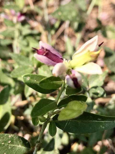 Sierra milkwort (Polygala cornuta) was nearly done flowering and had mostly dropped the flower’s side wings.
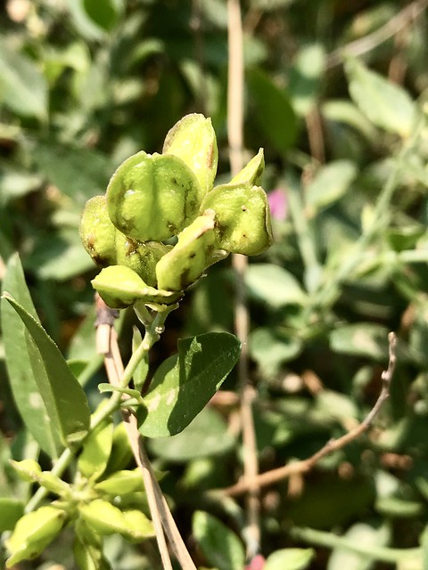 The milkwort had more fruits than flowers.
On the drive home, a momentary vista of Sawmill Peak offered a stronger reality check. The mountain looked as if a gauze curtain hung between us and I suspected the AQI had shifted back to orange as late afternoon winds carried more smoke upslope. It’s the tiny particles in smoke that make the air look thick and paint kaleidoscopic sunsets. I always considered those sunsets grotesquely beautiful, knowing what created them but still enjoying the colors. Now the vivid colors just say “fire and smoke.” I think about needing to stay indoors during summer, when in other years, I’m often outside. The sunsets are a sign of restriction and destruction.
Wildfire smoke contains “carbon dioxide, water vapor, carbon monoxide, particulate matter, hydrocarbons and other organic chemicals, nitrogen oxides, trace minerals and several thousand other compounds.”
Particulate matter is a generic term for particles suspended in the air, typically as a mixture of both solid particles and liquid droplets. Particles from smoke tend to be very small - less than one micrometer in diameter. For purposes of comparison, a human hair is about 60micrometers in diameter. Particulate matter in wood smoke has a size range near the wavelength of visible light (0.4 – 0.7micrometers). Thus, smoke particles efficiently scatter light and reduce visibility. Moreover, such small particles can be inhaled into the deepest recesses of the lung and are thought to represent a greater health concern than larger particles.
A NASA article on atmospheric aerosols offered a dramatic example of how visually clear air caused my congested lungs. Even when we can’t see particles unless a familiar mountain peak is obscured, the air is filled with aerosols from wildfires, agricultural burning, dust storms and other phenomena.
 23 August 2018
Satellites measure the aerosols by determining how the atmosphere reflects and absorbs different wavelengths of light. Red/yellow indicates black carbon aerosols produced from wildfires and other combustion (such as vehicles and industry). Purple is an indication of dust, and blue illustrates sea salt spray. On the map, we see wildfires in western North America shooting huge billows of smoke across the continent, over the Atlantic Ocean, and into Africa (red/yellow=carbon); three different tropical cyclones over the Pacific (blue=salt spray); and a Saharan dust storm (purple=soil/dust).
I was breathing all those carbon particles shown in red across the western US and along with the VOCs from burning vegetation. Here’s another view of the atmospheric aerosol debris.
Even if the air looks clear, it is nearly certain that you will inhale millions of solid particles and liquid droplets. These ubiquitous specks of matter are known as aerosols, and they can be found in the air over oceans, deserts, mountains, forests, ice, and every ecosystem in between.
Most of the aerosols (about 90%) are natural and the rest are manmade (e.g., fires, land disturbances like plowing and deforestation, vehicle traffic, industry). Where I was hiking, where I live, there is no industry and vehicle traffic is light (although particulate pollution from the Central Valley tends to settle out at my elevation). There is minimal plowing and no wildfire within 50 miles. But when wildfire aerosols from the western US travel to Africa, they have to move through my area.
Breathing polluted air doesn’t just hurt our lungs, it is also linked to reduced cognitive performance, chronic kidney disease, and premature death. It wasn’t until trying to take a deep breath the next morning, and failing, that I fully realized what I had been inhaling the previous day. I wished I’d known the danger before deciding to take the trip.
I searched for finer scale maps and data. The EPA Air Quality Monitors Interactive Map shows locations of all the on-the-ground/air monitors in the US. The data layers allow you to select the types of monitors (e.g., CO, NO2, Ozone, PM10) and to specify a location and zoom to it. The nearest air quality monitoring for particulate matter 10 is 10 miles away and nearly 3,000 feet lower, thus it doesn’t well represent my air. The nearest AQ monitor only measures ozone and is 7 miles away and 500 feet lower.
I’ve taken the air quality for granted. Sure sometimes in past years it was smoky from wildfires, but that rarely lasted more than a few days. This summer, the smoky air was orange AQI level (unhealthy for sensitive groups) or worse part of every day since the Carr Fire began on July 23rd. The Mendocino Complex began July 27th and added to the air pollution.
For me, this is the summer when the air changed. Not that it hasn’t been bad in previous years, but this year is a marker in time for air quality. When I thought about this benchmark approaching during the past few decades, I never thought I’d be part of a “sensitive group.” I’m concerned for the critters and plants and read about smoke altering some wildlife behavior. I remember forests losing pine trees to acid rain and wonder how AQ affects them. Birds are more vulnerable to smoky air than mammals. I wonder when someone will develop an AQI app for my phone that works in sites with no cellular service.
However, for the moment, my kidneys are healthy, my cognition is adequate, and I’m alive. The sky is blue. Last night the moon was white instead of orange. And the sunsets are nearly normal pale magenta.
|
SPOTLIGHT ON GREEN NEWS & VIEWS
EVERY SATURDAY AT 3 P.M. PACIFIC TIME
DON’T FORGET TO VIEW METEOR BLADE’S COLLECTION OF LINKS AND EXCERPTS FROM ENVIRONMENTALLY ORIENTED POSTS PUBLISHED ON DAILY KOS DURING THE PREVIOUS WEEK
|


