|
The Daily Bucket is a nature refuge.
We amicably discuss animals, weather, climate, soil, plants, waters and note life’s patterns.
We invite you to note what you are seeing around you in your own part of the world, and to share your observations in the comments below.
|
.
Full moon, December, January and February, winter 2018-19
Salish Sea, Pacific Northwest
Winter is the season for King Tides, when astronomical and weather conditions raise our high tides higher than usual. Around Winter Solstice the earth is closest to the sun in its orbit (perihelion) and this past midwinter the moon has been closer to the earth too (perigee), both of these configurations gravitationally raising the water level during high tides. The December full moon coincided exactly with winter solstice this winter. Tide tables use all these known astronomical configurations to make forecasts, and we were expecting maximum high tides for the year on particular days in December and January.
But those gravitational forces generating King tides were amplified in December by a strong low pressure weather system that blew through just before Solstice. Lower atmospheric pressure allows sea level to rise locally, and its effect was compounded by the accompanying storm surge pushing the ocean onto shore. For background on astronomical factors see www.cbc.ca/…, and for weather factors www.linz.govt.nz/….
I was looking forward to seeing some dramatic shoreline King Tide activity!
The day before Solstice I made my rounds of several local bays near my home. Wind-driven waves were crashing on the west-facing bay as I expected. But what astonished me was how high the water rose in the more protected bays. I took some photos and video on December 20 and then again on January 19, the day before the next full moon’s high tides for comparison. The January highest tides were forecast to be about the same height as December’s (remember the Supermoon eclipse? ie closer to the earth than usual). But this time the weather was calm. No atmospheric effect on the high tide.
Take a look at how much higher a storm’s effects lift sea level.
At a bay with a high-bank shoreline:
 Erosion of clay bank on both sides of the bulkhead
Aleck Bay has steep cliffs of bedrock except at the end, which is lined with a 20-foot vertical bluff of clay, laid down by glaciers during the Ice Ages. Over the years the ocean has been carving this bluff further back. During the 30 years I’ve lived in this neighborhood I’ve been watching the bank progressively crumble and fall onto the beach. Shrubs and trees are undercut and give way, collapsing onto the beach below. A concrete bulkhead was built onto the bluff about 40 years ago surrounded by big rip rap boulders and now extends 10 feet out as the clay bank erodes on either side.
The tide table forecast a 9-foot King Tide, but with the fairly deep low pressure storm center passing over us the water level was at least a foot higher than that. Waves washed right up against the bank. Driftwood that had floated off beaches elsewhere was bashing against the bank loosening the clay even more.
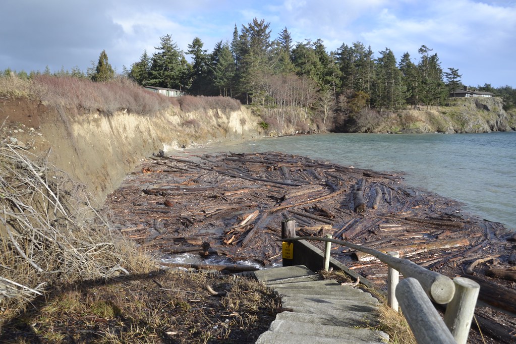
A video clip shows the water and driftwood in action.
January’s King Tide was also forecast to be 9 feet. With the calm weather this time, the water did not rise high enough to reach the bluff. Note how the highest driftwood is still dry. The force of any waves was mostly absorbed by the driftwood resting on the beach.
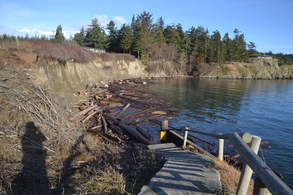 January 19, 2019
During the rest of the year, the highest high tides barely reach the driftwood at all. Another day in January shows the sea at a more typical high tide, with even some beach visible. This is what high tide looked like on this month’s recent full moon, on February 19, a 7.5’ tide.
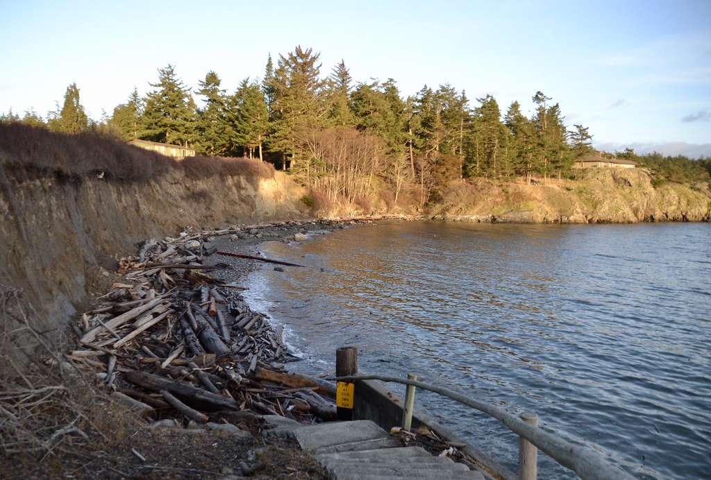 January 4, 2019
At a bay with a no-bank shoreline:
The other bay where I observed King Tide effects is the most protected of all the local beaches. There’s no surf at this one but the sea rose high enough to flood right onto the road and up into the docks. This was in spite of the border of rip rap rocks and dirt pushed up there a century ago to raise the land high enough for a dry road along the bay. Before the roadworks, the sea washed right into the lowlying land on the other side of the road. It was a salty marsh before it was turned into a hay field and houses.
The December 20th photos were taken about 30-45 minutes after peak King tide, when water level was already subsiding. The wet road indicates where the sea was washing over.
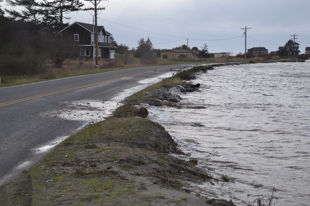 Dec 20.
This bay is so well protected from surf and currents that three docks have been built there, where boaters can safely moor their craft in any weather. The decks of the docks are the same level as the road. At King Tide the docks were nearly underwater.
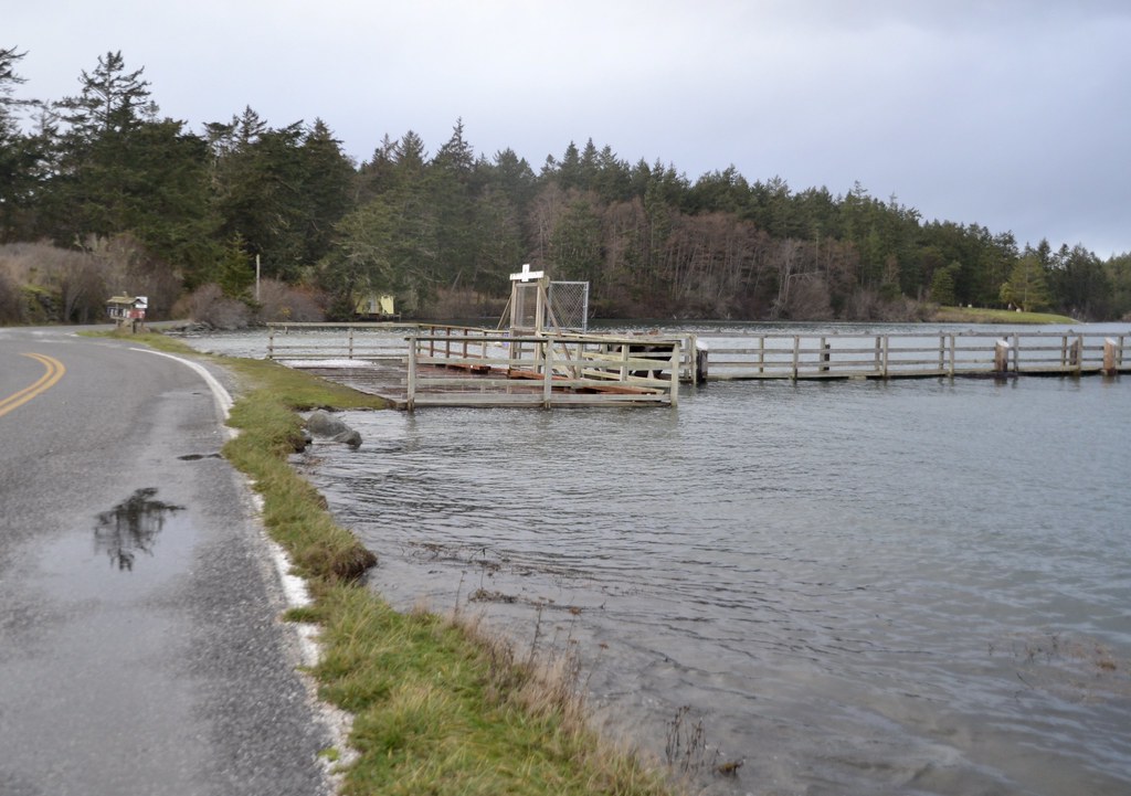 Dec 20
Even after peak high tide it was mesmerizing to watch the swells lifting the planks of this dock. At low tide I can walk right under this dock.
In contrast, January’s King Tide left little beach but at least the road and dock remained dry.
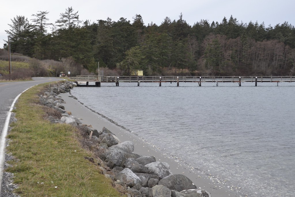 Jan 18
A preview of the future
These extreme high King Tides are not just a curiosity and dramatic event to witness. They are significant as a preview of what normal high tides will be like as sea level rises. Global warming is relentlessly raising sea level here in the Northwest as it is elsewhere. The expansion of water as it warms and increasing quantities of water from melted ice sheets have already raised sea level about 9” since 1900 (www.eopugetsound.org/...). Because this road is being measurably chewed away year by year, the county is already in the planning stages of rerouting it inland. On the west-facing beach, the road was reduced to one lane last year since the edge of the seaward lane has fallen onto the beach below. It will be very expensive to replace the road: acquiring private property, avoiding environmentally sensitive wetlands, construction costs, rerouting the accompanying electrical lines and water pipes. But if the existing road washes away, 80-some homes will lose vehicle access to the rest of the island.
Forecasts for regional sea level rise (www.wacoastalnetwork.com/...) have a range depending on future greenhouse emissions. If major steps aren’t taken soon, models predict a 1 to 2 foot increase in the next 30 years, and 3-8 feet by the end of the century:
I can see personally and concretely what that will mean to the shorelines near my home and elsewhere on the island. Houses by the shore owned by neighbors I know will be flooded and uninhabitable. Roads and utility corridors will have to be rebuilt elsewhere at huge cost to my county and state, likely diverting funds that would have gone into infrastructure repairs elsewhere or other public needs. Waterfront properties are the most highly taxed so the county will lose disproportionately more income as those become non viable, and have less to spend on mitigation. Most folks here depend on wells as a water source and a rise in sea level will cause saltwater intrusion into wells on the perimeter of the island. Pollution sources like septic systems will be flooded, releasing into marine ecosystems already stressed by warming, acidification, overfishing, invasive species, spawning-habitat loss, and other problems.
These are not vague distant-future possibilities, but issues that will emerge within my lifetime. The dramatic scenes I witnessed on King Tide days are a grim forewarning for the future of communities not just along Salish Sea shores but for shorelines everywhere. We won’t be able to lower sea level but we can slow its rise. Otherwise, people in future calamitous decades will be looking back at the early 21st c wondering why we didn’t save what we had when we could.
This month’s supermoon high tides have been extremely high too, although not as high as December’s King tides. I’m keeping my memories and pictures of them front and center as I make my daily rounds along the shore as a reminder to do what I can. Soon those scenes of shorelines being chewed up by high water won’t just be once a year, but monthly or daily if we don’t take collective action soon.
Do you have something in your immediate neighborhood you use as a reminder of the dangers of unrestrained climate change? As a global crisis, it is affecting all of us. I’d be interested to hear what stands out for you.
🦐
Today weather in the islands is partly cloudy and cooler than normal for this time of year, 34°. Light north wind.
What’s up in nature in your area today?
🦐
|
"SPOTLIGHT ON GREEN NEWS & VIEWS"
EVERY SATURDAY AT 3:00 PM PACIFIC TIME ON THE DAILY KOS FRONT PAGE.
IT'S A GREAT WAY TO CATCH UP ON DIARIES YOU MIGHT HAVE MISSED. BE SURE TO RECOMMEND AND COMMENT IN THE DIARY.
|


