Whidbey Island was not our destination a fortnight ago on our way out to the Olympic Peninsula but it turned out to have a few birdies passing by, which I can share today.
 Point Wilson on the Olympic Peninsula (pinned) is where the tweeters poster was seeing the birds going by. The ferry goes between Port Townsend and Keystone (under the W of Wilson).
Whidbey is the largest island in Washington, about forty miles long, and we cross just part of the northern end en route from where we live in the San Juan islands to get to the open ocean. A bridge connects Whidbey at its far north end but it takes a ferry to get over to the Peninsula (there’s another ferry linking the southern end to the mainland near the Seattle metro area).
 Larger view, western Washington
Our route was across to Anacortes, down through Fidalgo Island onto Whidbey Island, crossing the Inlet south of Coupeville to Port Townsend, and then on west to the open ocean.
It just so happened that the morning we left home I read a posting in the University of Washington daily birdserv email feed “Tweeters” that thousands of marine birds were regularly flying north and south through the northern end of Admiralty Inlet, the section of the Salish Sea our ferry would be crossing in a few hours. Good to know! It would be worth standing out on the car deck for the 9-mile 35 minute crossing to see if I could catch any of that action, even though we’d be crossing in the middle of the day and the person posting the observations said the numbers peak early and late.
I saw very few birds until we were more than halfway across, which explains why the Tweeters poster was stationed on the Peninsula side.
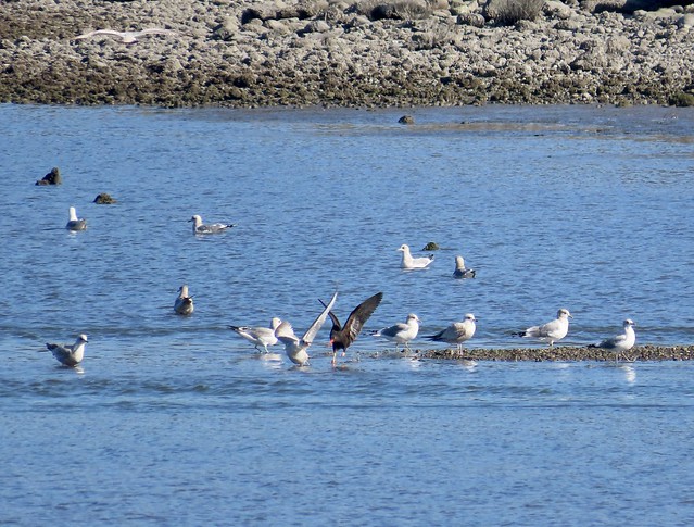
 Port Townsend ferry dock, birds between our ferry and the dock
The light was bad though since the ferry was traveling west/southwest. I got much better looks when we returned four days later. Heading east/northeast from Port Townsend to Keystone, the light was behind me. It was a calm sunny day with nearly flat water, pretty unusual for March hereabouts.
Near the Port Townsend dock, Pigeon Guillemots, Surf scoters, Red-necked grebes, gulls, and cormorants cruised around locally, as much foraging as flying.
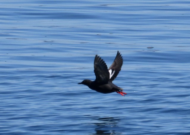 Pigeon guillemot in breeding plumage
 Common loon in transition
 Drake Surf scoters
 Red-necked Grebe, breeding colors
 Steller sea lions too
Farther out, a constant stream of birds flew close over the surface, nearly all southbound. The poster said he sees them going south in the morning and north in late afternoon, so I’m guessing the morning movement is quite drawn out since it was 1-2 pm when we were crossing, both days.
Camera was at maximum zoom (65x) so I’m seeing several miles of water.


 Unzoomed view from the deck. That’s Kulshan aka Mount Baker in the distance to the northwest (BrownsBay had a great zoomed photo of that mountain and a ferry in last week’s Dawn Chorus about Snohomish county, which is directly east of Whidbey Island). Glassy water!
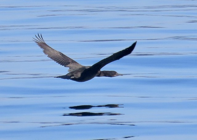
 One Common murre and several Rhinoceros auklets
 Same murre, overtaking the auklets.
Some birds fly faster than others, like the murre vs the auklets above. Cormorants fly faster than both.
 Cormorants following Murres and auklets….
 …and overtaking them. Photobomb by Red-necked Grebe on the water.
The cormorants were hard to ID given the distance. I did see Brandt’s for sure though.
 Brandt’s cormorant, with tan cheek path.
Notice how all the birds are flying right above the water. They are taking advantage of the “ground effect” which drastically reduces their energy expenditure. The diagram at the link shows why flying low increases lift and reduces drag. Birds are smart.
On approach to the Keystone terminal on Whidbey, Camp Casey can be seen nearby:
 Camp Casey, on shore in the background, used to be the residential quarters for Fort Casey, one of three forts built by the US Army at the entrance to Admiralty Inlet in the 1890s to protect strategic interests in Puget Sound to the south. It is currently owned by Seattle Pacific University and used as a conference center, kids camp and event center for groups.
The tweeters poster opined (report: Pt Wilson seabirds: massive daily movements in both directions) that the birds spend the night in the eastern Strait of Juan de Fuca, north of Point Wilson, with the Rhinoceros Auklets at their breeding colony on Protection Island there. During the day, birds head south into Puget Sound and Admiralty Inlet to forage. Could be.
 Common murres diving
It was certainly impressive to see them going by, especially the alcids, those tiny wings flapping hard. I didn’t see the numbers that the poster did, reported to eBird, but there were thousands total. The named birds in my photos here were taken within a half a mile of the ferry; most birds were too far away for me to positively ID.
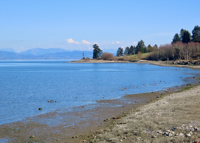
The other birdy passersby on Whidbey I saw were at a new birdwatching site I learned about from a book I just got, Getting to the Water’s Edge on Whidbey and Camano Islands, published by Sound Water Stewards, a group of volunteers who monitor shoreline ecosystems and do educational outreach. Turns out Whidbey has a lot of public shoreline access! We skipped Oak Harbor’s bay this time (where I saw all those oystercatchers in January) to check out new sites. We had just enough time before our Anacortes ferry run to scope out the kelp bed at Partridge Point on the west side (no birds there unfortunately) and to stop at Dugualla Bay Preserve on the northeast side. The Preserve is 200 acres owned by the Whidbey Camano Land Trust, which has spent the past ten years restoring fresh and saltwater wetlands on old farmland.
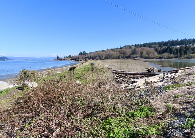 View from the parking lot: salt water on left, fresh on right. There’s a path with interpretative signs between them on a low dike. Skagit Bay and the Skagit river delta are across the water to the east.
 Blue lines are touch-and-go ops out of Ault field (north) and Outlying Field Coupeville (south)
One real bummer about this site is it’s under the flight path of the EA-18G jets (“Growlers”) stationed at Naval Air Station Whidbey Island. When we were there, the jets were practicing touch-and-go flights out of Ault Field, which means taking off at full throttle wheels and flaps down, turning in a tight low circle, landing on the runway momentarily, and taking off again. Over and over and over until the fuel is used up. The purpose is to learn how to land on an aircraft carrier deck (“field carrier landing practice” or FCLP, as labeled in the diagram).
 If you don’t believe me, check out this Google Earth image. The parking lot is in the center of the image and two EA-18G “Growler” jets are about to pass directly over it.
For anyone nearby, the noise is literally deafening, over 120 decibels (as even the DoD admits “on occasion” although they report noise as much lower in their official reports by averaging when flights are active and not), the jets so low you instinctively duck. We couldn’t stay longer than ten minutes since it was literally painful, as in ice picks getting jammed in your ears (as bad luck would have it, when we were catching the Keystone ferry over to the Peninsula on the previous Friday, the jets were doing touch-and-go flights out of OLF Coupeville, equally loud. It’s bad enough where I live on the southern edge of the San Juan islands, where the jets circle at 1000 feet, but I feel really sorry for folks who live under those low FCLP paths. Just ask Lefty Coaster what it’s like — he lives near Coupeville.)
 Two EA-18G jets who just made the turn and were heading back to Ault Field.
There were a few birds foraging at Dugualla Preserve, both in the wetland and the bay. Not as many as I’ve seen listed for the site recently, perhaps noise deters them. Canvasbacks are regularly seen there according to eBird reports, but there weren’t any during our visit. They would be a real prize for me to see — they are rare out in the islands, and I’m pretty sure I’ve never seen one.
But there were plenty of Northern pintails and Mallards in the bay, with some Green-winged teal and Gadwalls (more teal in the wetland, along with some wigeon, geese, a heron and possibly other birds there — the sun was in my eyes).
 Ducks foraging in shallow mudflat at a fairly high tide
 Pintails foraging
Two views of a pintail’s pin tail:

 Also a GW teal
Down the beach a flock of Mew gulls (aka Short billed) foraged along the shore with a couple of Black oystercatchers. One oystercatcher even chased away some gulls.
 Oystercatchers and Mew gulls are about the size.
The other shorebirds I saw at Dugualla were about a dozen Greater Yellowlegs. While their numbers peak in spring and late summer, Greater Yellowlegs are one of the few shorebirds you can expect to see in western Washington year round. I guess the ones we see in winter and summer are just not migrating. This bunch was probably packing in calories en route north.


Trumpeter swan numbers have been thinning out in the past month or so, and soon every one of them will be gone north. I did see a flock of about 30 in a field where you turn off the main road toward Dugualla Bay. In winter the farm fields of the Dugualla valley usually have hundreds of swans.
 Muddy Trumpeter swans
Most of these birds we saw that weekend were passing by Whidbey Island, either daily movements or seasonal migration. We were passing through too. Perhaps the next time we’re down there our timing will match up better with theirs. Even so, we got a chance to see some new sights and sites on our way. Might even make a special trip to Whidbey for dedicated birding!
 Any western Washington birders or visitors: I highly recommend this handbook that shows you public access spots along the Whidbey (and nearby Camano Island) shoreline. Published by Sound Water Stewards, it is packed with useful information, like directions, parking, accessibility, hiking, birding, invertebrate wildlife, natural history, geology, beach dynamics, and more.
The Dawn Chorus is now open for your birdy reports of the week.

