In some previous energy independence diaries (list below the fold), I have mentioned retrofitting the suburbs. That is because suburban sprawl creates gross energy inefficiency. However, one of the common objections, when this point is raised, is that Americans are not going to vote for policies to pack them into dense urban landscape ... Americans, we are told, like the space.
SO I am sketching out how this may work. Retrofitting outer suburbs means recreating the option in the outer suburbs of living in conditions like a compact small town. In the town that I am writing from, large numbers of people drive everywhere they go. However, it is possible to walk to the supermarket, the post office, a pastry shop, a coffee shop, etc. ... with etc. including more pizza places than you can shake a stick at.
This is crossposted from the OAC, and the original diary was too big for the Daily Kos. So its been broken into two parts. The sketch of retrofitting an outer suburb below the break.
Energy Independence Diaries:
A Dedicated Transport Corridor
See Part 1 of this diary for the discussion of why a dedicated route transport corridor is a key element of retrofitting an outer suburb, and a few of the reasons that the Aerobus system is used as part of this sketch
To make a short story long, click through and read part 1. Suffice it to say that any dedicated route transport system that a locality decides fits its particular situation is fine. This is not a "public transport system wars" diary.
I am sketching with the Aerobus because it is an elevated system with a long span between pylons (up to a mile), so that it eliminates or minimizes the problems of grade crossings that will sometimes interfere with other forms of light rail vehicle. The sketch is not specific to any specific transport system, and using the Aerobus allows me to push into the background the problem of running the route through the inner suburbans and into the city.
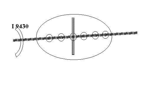
An ordinary suburban stop
The Aerobus comes down to an island platform ... a platform about 4 feet high with wheelchair accessible ramps off both ends will given clearance of more than than 7' above the entry. There are cycle posts and locking cycle lockers on the sidewalk side of the platform, and of course park and ride parking on the off street side. The area surrounding the stop is zoned for higher density residence, reducing down in steps with distance from the stop.
What does "higher density" mean? The first ring is 5 minutes "standard walking distance" to the stop, which is about a quarter of a mile. In the immediate vicinity of the stop, this may mean commercial use on the ground floor with 2 story townhouses above. A block away, it may allow for stacked townhouses, with a pair of ground floor and basement "garden" townhouses supporting first and second floor "patio" townhouses. The patios in the rear, of course, are the roof of the garages for the four units. The next ring, about a quarter mile for 5 to 10 minutes walk to the stop, is zoned to allow medium density freestanding townhouses. Outside that ring, the existing zoning applies.
Mind you, allowing the residences to be built does not ensure that they will be. One thing that would help is a Connie Mae system of financing is available, then the utility bill savings of townhouses compared to free standing houses would allow for easier finance. However, the main point is to allow for the option of infill residential development. When the next wave of high gas prices increases the appeal of convenient access to the dedicated transport corridor, developers will begin to take advantage.
Additional steps can be taken to encourage developers to take up these infill development opportunities. An important one is to permit, and encourage, utility companies to take into account the costs imposed by low-density development. This will mean the utility hook-up fee is based in part on the square feet of the site receiving the hook up.
A Shopping Center Stop
The transport corridor must bring people to the existing commercial sites, which means providing a stop for a shopping strip or shopping mall. If the shopping center is well placed, this is also likely to be a strategic location for local circulator buses to interchange with the line, as well as for a larger scale park and ride facility.
But, but, but, but ... the shopping center will object ... it needs those parking spaces. Well, that's fine. After all, the point of an elevated transport corridor is to have freedom to rise above obstacle. In this case, a second deck of parking over a portion of the shopping center parking lot for park and ride commuters, integrated into access to the shopping center, turns a negative into a positive. It becomes even more of a positive for the local area if the elevated location of the stop is used to provide pedestrian bridges over the street or streets that originally attracted the shopping center to this location.
On this point, I am going to encourage you to click through to the Community Transformation examples that simulate what infill development can do to the "shopping strips" that populate the country. These are made available by the Sierra Club as part of their Anti-Sprawl campaign. The slideshow starts with El Cerrito, California, and cycles through examples in Kendal Florida; Hercules, California; Denver, Colorado; and Oakland California. Note that the examples include light rail, so imagine an Aerobus track crossing somewhere with an elevated stop. (If you like, you can leave the light rail there in your mental picture ... it is straightforward to design an interchange).
As you can see, infill development along these lines in a high traffic shopping area evolves into a streetscape ... well, that is very much like the center of a large town ... professional office space, shop top apartment buildings, street front retail and restaurant sites.
What About the Rest of the Suburb
So far, all our time has been spent along the dedicated transport corridor. What about the rest of the outer suburb?
Up front is the obvious point that we cater to the whole suburb when we provide park-and-ride facilities at each of the stops along the dedicated transport corridor. For truly dedicated park-and-riders, this by itself represents a substantial reduction in the public subsidy they are demanding for their driving, since they are moving from the average of seven parking spaces per car in the direction of a much lower impact two parking spaces. Dedicated park-and-riders will also reduce their dependence on liquid fuel ... and with a pluggable hybrid vehicle (PHEV) could well go a month or more between trips to the gas station.
So with the dedicated transport corridor in place, the "rest of the suburb" may look the same as it did before, but has the option of being far less greedy in terms of land and fuel than under the present "car or nothing" system. Becoming more efficient in one area, of course, means that inefficiencies in other areas loom larger. Here is where a Connie Mae system of lending against utility savings has tremendous leverage. From ultra low watt light bulbs to insulation to decentralised solar and wind power applications, Connie Mae encourages people to invest in the energy efficiency and energy productivity of their home.
The option to live with fewer cars per household ... or even none ... also increases beyond the immediate vicinity of the dedicated corridor. This will become increasingly important as the highest priority issue with gasoline and petrodiesel switches from price to availability.
Partly, this is repeating a point that I already made regarding transport cycling. If, roughly speaking, a transport cyclist is four times the speed of a pedestrian (mind you, this is not cycle racing we are talking about here!), then the 15-minute radius to the transport stop covers 16 times as much landscape. And we already have the network of cycle paths that we require in every outer suburban residential area ... they are called streets.At the same time, the presence of the dedicated transport corridor increases the appeal of cycle transport, because once you reach the dedicated transport stop, you have access to the range of opportunities provided by the collection of stops on the line.
This provides a transport cycling belt extending away from the transport corridor ... on both sides if the corridor runs through the suburb.
Second, for those outside the immediate vicinity of the transport corridor, we have changed the public transport problem. Rather than being a problem of how to get to the individual destinations, it has become a problem of how to get to the transport corridor. And this can be provided efficiently by a variety of local bus routes. One is a "figure eight circulator". If the dedicated corridor is running east and west, the circulator runs one closed loop to the north of the corridor, and then continues on a closed loop to the south. A 12 minute loop allows for service twice an hour with one circulator mini-bus ... or every 10 minutes with three.
Put Yourself In This Picture
So now I can pull the sketch together ... though I should say sketches, because I am going to follow the Community Transformations model of sketching stages of transformation.
In Stage One, the corridor itself is put in place, and the supporting social framework for infill development ... Connie Mae, density-based utility connection fees, zoning changes, changes in taxes and subsidies ... the whole ball of wax. So what you have is what you have now, except for the transport corridor. At each spot is parking for park and ride use of the line, the owners of the highest appeal shopping centers along the line that played along may have a bus interchange, a share of the residents in the suburb who work in the urban area accessed by the line can sit reading their paper or paperback while their hapless colleagues are trapped in the traffic jam below.
In Stage Two, the suburban village clusters have started to spring up, as developers start to build ... and some of those hapless colleagues decide they want to live near the option to avoid the traffic. Those suburban villages start to attract a mix of local commercial development, with a handful of small professional offices that find the location more convenient than a free standing office park.
In Stage Three, the increase share of foot traffic coming via the corridor increases the demand for pedestrian friendly development in the vicinity of the main shopping center stops along the line. Indeed, Stage Three may look very much like the Community Transformation pictures, because a radial light rail (or BRT) corridor may be demanded by commercial establishments who are located off the main dedicated transport corridor ... duplicating the pre-WWI system of interurbans and trolly lines. And of course, as the main shopping center becomes more pedestrian friendly, there will be an increase in demand for professional office space in that area.
The end picture, then, is a mix of town centers, mini-villages and single dwelling suburban settlement. The energy efficiency of the system per person is substantially higher, further improved by decentralized energy production, and a smaller share of that demand must be served with liquid fuel.
Of course, that means that a larger share of energy is coming from electricity ... to run transport on the corridor and a major share of transport to reach the corridor. Where that electricity is to come from ... well, that is where Sustainable Energy Independence has to be very careful about the climate crisis and CO2 emissions. That means that the next Energy Independence diary could be about the Winds Of Lake Erie.
This is just one sketch. For more sketches, and lots more information, a good springboard is the Transit Oriented Development website.
