In an earlier diary about the resignation of the first executive director of the Carter Center -- Emory Professor Kenneth Stein -- I highlighted Stein's claim that President Carter's new book "is replete with factual errors, copied materials not cited, superficialities, glaring omissions, and simply invented segments." Now, thanks to Rick Richman at Jewish Current Issues, we have some clear, incontrovertible proof. As Richman shows:
Carter not only appears to have copied maps from [Dennis] Ross but -- more importantly -- to have re-titled them to make them appear to be something they are not. Moreover, his maps omit the descriptive notes that Ross included on his maps, which would have contradicted the point Carter was trying to make.
"Finally," Richman adds, "the point he [Carter] was trying to make with the borrowed and altered maps is central to his entire book."
The proof is below the fold.
Some readers will be familiar with the map I have used to illustrate the territorial aspects of the Clinton Parameters, which is the set of proposals made by President Clinton to the Israeli and Palestinian peace delegations in the White House on December 23, 2000. The map is taken from Dennis Ross's The Missing Peace: The Inside Story of the Fight for Middle East Peace, which President Clinton endorsed, as follows:
"THE MISSING PEACE is the definitive and gripping account of the sometimes exhilarating, often tortured twists and turns in the Middle East peace process, viewed from the front row by one of its major players, Dennis Ross. No one worked harder for peace than Dennis. He gave it everything he had and served our nation very well. Now he has provided us with a rich account of what happened that is essential to understanding both the past and the possible paths to the future."
In summary form, President Clinton proposed:
-- a Palestinian state on approximately 97% of the West Bank (phrased as "between 94 and 96 percent of West Bank territory" plus a "land swap of 1 to 3 percent," for a total of between 95 and 99 percent -- with 97% thus being the midpoint), and 100% of Gaza, with "contiguity of territory for each side" and 80 percent of the settlers remaining in blocs within the retained 4-6% area;
-- a capital in East Jerusalem, with sovereignty over all Arab parts of the City (including Arab parts of the Old City) and Palestinian sovereignty over the Temple Mount;
-- an unlimited right of refugees to return to the new state of Palestine, plus limited absorption of refugees into Israel (depending on Israel’s policies and sovereign decision); and
-- an international presence for security purposes as Israel withdrew from the West Bank, with a "small Israeli presence in fixed locations" remaining in the Jordan Valley -- under the authority of the international force -- for a limited time.
Ross's map actually understates the size of the Palestinian state because, as it says in a box on the map, the map does not show territory from pre-1967 Israel to be added to Palestine. Here's Ross's map of the Clinton Parameters:
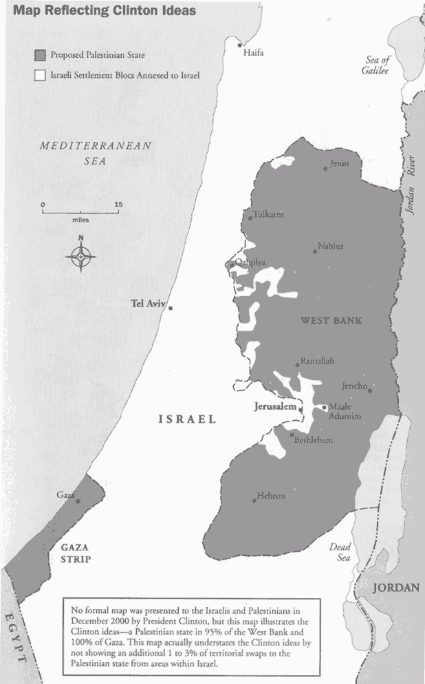
As the map illustrating the Clinton Parameters shows, the proposed state of Palestine would have consisted of
- the entire Gaza Strip; and
- nearly all of the West Bank, including the Jordan River Valley.
In other words, no bantustans. The Israeli Cabinet accepted the President Clinton's proposals; Arafat and the PLO rejected them. According to President Carter, however, Israeli Prime Minister Barak gave "no clear response," "but he later stated that Israel had twenty pages of reservations. President Arafat rejected the proposal"--which Carter justifies because (supposedly) "no Palestinian leader could accept such terms and survive." (pp. 150-2)
Here's Carter on CNN:
CARTER: I hate to dispute Bill Clinton on your program, because he did a great and heroic effort there. He never made a proposal that was accepted by Barak or Arafat.
BLITZER: Why would he write that in his book if he said Barak accepted and Arafat rejected it?
CARTER: I don't know. You can check with all the records, Barak never did accept it.
President Carter was wrong. First, here's Dennis Ross's response:
ROSS: That's simply not so.
BLITZER: Who is right, Jimmy Carter or Bill Clinton on this question which is so relevant as to whether or not the Israelis at Camp David at the end of the Bill Clinton administration accepted the proposals the U.S. put forward?
ROSS: The answer is President Clinton. The Israelis said yes to this twice, first at Camp David, there were a set of proposals that were put on the table that they accepted. And then were the Clinton parameters, the Clinton ideas which were presented in December, their government, meaning the cabinet actually voted it. You can go back and check it, December 27th the year 2000, the cabinet voted to approve the Clinton proposal, the Clinton ideas. So this is -- this is a matter of record. This is not a matter of interpretation.
Here's more evidence of Carter's error:
- Yossi Beilin was in Barak's cabinet. Beilin was one of the key figures in negotiating the Oslo Accords between Israel and the PLO. He now serves as leader of the dovish, leftwing opposition party Meretz-Yahad. In his account, The Path to Geneva: The Quest for a Permanent Agreement, 1996-2004 , Beilin writes: "On December 28 [2000], at a meeting of the government, the [Clinton] plan was endorsed in principle . . . From that moment, the Clinton Plan embodied Israel's stance on the Palestinian-Israeli issue." (p. 223)
- Dennis Ross agrees: "Barak’s government had now formally accepted ideas that would effectively divide East Jerusalem, end the IDF’s presence in the Jordan Valley, and produce a Palestinian state in roughly 97 percent of the West Bank, and 100 percent of Gaza" (The Missing Peace p. 755)
- So does Israel's then foreign minister, Shlomo Ben-Ami, in his Scars of War, Wounds of Peace: The Israeli-Arab Tragedy (p. 272).
- And so, too, does President Clinton: "Arafat’s rejection of my [December 23, 2000] proposal after Barak accepted it was an error of historic proportions." (My Life, pp. 944-45)
President Carter purports to explain why the Clinton Parameters were unacceptable to the Palestinians. In so doing, Carter misrepresents the Clinton proposals and presents maps that, as Carter uses them, are false and misleading. Here's what President Carter claims (pp. 150-51):
There was no clear response from Prime Minister Barak, but he later stated that Israel had twenty pages of reservations. President Arafat rejected the proposal.
. . . The best offer to the Palestinians – by Clinton, not Barak – had been to withdraw 20 percent of the settlers, leaving more than 180,000 in 209 settlements, covering about 10 percent of the occupied land, including land to be "leased" and portions of the Jordan River valley and East Jerusalem.
. . . This honeycomb of settlements and their interconnecting conduits effectively divide the West Bank into at least two noncontiguous areas and multiple fragments, often uninhabitable and unreachable, and control of the Jordan River valley denies Palestinians any direct access into Jordan.
Richman points out seven errors in President Carter's claims:
- The Israeli cabinet formally accepted the Parameters on December 27, 2000, as both President Clinton and Ambassador Ross understood.
- Under the Clinton Parameters, all of the settlers would have been removed from a Palestinian state, which would have covered 94-96% of the West Bank.
- There would be no "honeycomb" of settlements dividing the West Bank.
- President Carter’s 10% figure is double the 4-6% figure expressly set forth in the Clinton Parameters.
- No part of the Jordan River Valley was to be permanently retained by Israel.
- Even the "small Israeli presence" for security purposes would be withdrawn within a fixed period.
- The Palestinians would have had direct access to Jordan along the entire border.
At page 148 of his book, President Carter uses two maps to support his claims and justify Arafat's rejection of President Clinton's proposals. The first map appears to be copied from Dennis Ross:
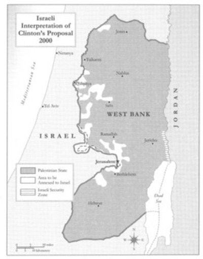
You'll notice that, where Ross (accurately) captioned his map "Map Reflecting Clinton Ideas," Carter erroneously retitled it, "Israeli Interpretation of Clinton's Proposal 2000." Carter also failed to include Ross's note that the map understates the size of the Palestinian state because it does not show territorial compensation from Israel.
Why would President Carter present Dennis Ross's illustration of the Clinton Parameters as an Israeli interpretation? The answer lies in Carter's next map, which he labels the "Palestinian interpretation." This allows Carter both to say that the Clinton proposals were unclear and that the Palestinians had good reason to reject them:
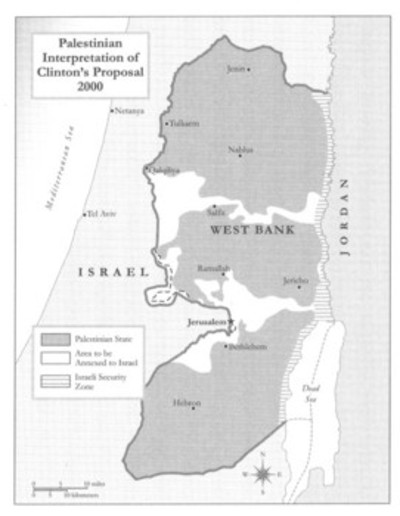
Richman observes:
But this Carter map is a totally false illustration of any possible interpretation of the Clinton Parameters, and you can tell it is false not just by reading the Parameters themselves, but by looking at Ross’s second map (and its explanatory note), from which Carter's map apparently came.
Below are two maps from page xxiv of Ross's book. The map on the left is the one that President Carter appears to have copied:
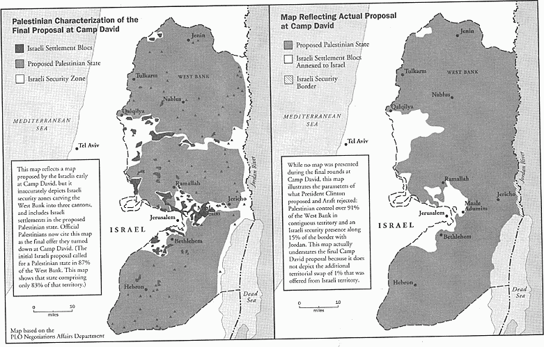
But as the caption to Ross's map makes clear, it's not a map of a Palestinian interpretation of the December 2000 Clinton Parameters. Rather, as Ross has labeled it, it's the "Palestinian Characterization of the Final Proposal at Camp David," from July 2000.
The Palestinian characterization is false. As the map on the right shows, the map on left actually is an incorrect depiction of the initial Camp David July offer. The map on the right, which Carter did not use, shows that, like the Clinton Parameters, the final Camp David proposal also had a contiguous Palestinian West Bank without banutstans.
Also, President Carter left out Ross's note on the left-side map. It explains that the map "reflects a map proposed by the Israelis early at Camp David." That is, it's not the final Camp David offer, much less -- as Carter calls it -- an "interpretation" of President Clinton's December 23 proposals. And Ross also noted on the map where it came from: the PLO Negotiations Affairs Department.
Here's the (misleading) PLO map:
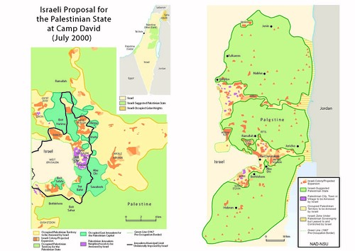
Part of what's misleading about the PLO map is that, as Ross notes, it "inaccurately depicts Israeli security zones carving the West Bank into three cantons and includes Israeli settlements in the proposed Palestinian state." Ross also noted that the PLO map shows the proposed Palestinian state as "comprising only 83% of [the West Bank]" instead of the 87% that Israel then was offering.
Richman's conclusion seems inescapable:
The two maps on page 148 of Carter's book are thus either virtually identical or substantially the same as those in Ross's book, which Ross has said he created himself. But the titles have been changed, and the explanatory notes omitted, and the maps are being used to illustrate a demonstrably false point.
As Jimmy Carter's new book comes under increasing scrutiny, its flaws become increasingly clear: a sad and strange chapter in his otherwise outstanding career of public service.
