You are in the current BP disaster ROV, number 198. Number 197 is here.
Please DO NOT Rec this diary, rather REC THE MOTHERSHIP instead. She needs your love to stay afloat.
Please be kind to kossacks with bandwidth issues. Please do not post images or videos. Again, many thanks for this.
PLEASE visit Crashing Vor and Pam LaPier's Diaries to find out how you can help the Gulf now and in the future. We don't have to be idle! And thanks to Crashing Vor and Pam LaPier for working on this!
For a description of the mothership/ROV liveblogging process, check out this thread.
Must read: Lax Oversight Seen in Failure of Oil Rig's Last Line of Defense. Watch video and interactive graphic page, too. Best overview of how the BOP works, and doesn't work, and the management interference that caused the accident.
Deepwater Horizon BP Oil Spill Reference Material - from Whitis is the best source for everything.. The quantitative data diary has also been moved there.
Jeff Masters of Weather Underground posted his take on the effects of a hurricane passing through the Gulf and making landfall.
Please DO NOT Rec this diary, REC THE MOTHERSHIP HERE.
BP put up a video explaining the LMRP procedure and the future plans.
Go to the Deepwater Horizon Data Summary for a wealth of actual data from the Department of Energy.
The BOP and pressure drawings are viewable here. The CAD drawings come highly recommended by the techies among us. h/t Claudius Bombarnac.
This is what BP DOES NOT WANT YOU TO SEE. The following images are guaranteed to make you SICK AT HEART.
These images are not for the faint of heart - DO NOT VIEW THEM LIGHTLY.
Really, I mean it. Hold somebody's hand. Grab a tissue.
A brief reference guide to nicknames you may see in the ROV diaries:
- Gertrude, aka Gerty: the oil volcano
- Lizzy: the diamond saw cutter
- Clampy: the cute ROV
- Crunchy: 30 ft shear. bit the pipe, now a movie star
- Wanda: the dispersant sprayer
- laundry basket: yellow thing that brings things up and down
- Thingy: those things, you know, those things
- Shiny Thing: those really neat things
- Ms. Blanche Flo, aka Blanche, aka Flo: the manifold thingy
Thanks to dov12348 for publishing a diary on Oil Terminology.
Here is a tutorial on the sources of pressure on the well
H/t to Pluto for finding this:
The official casing configuration under the wellhead.
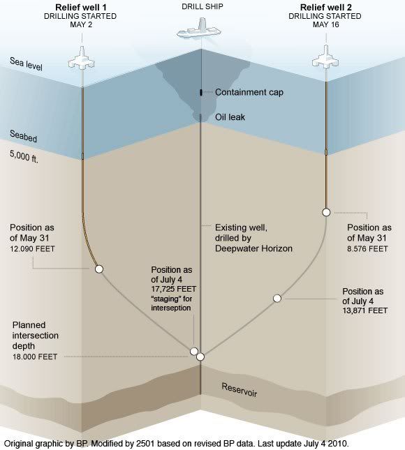
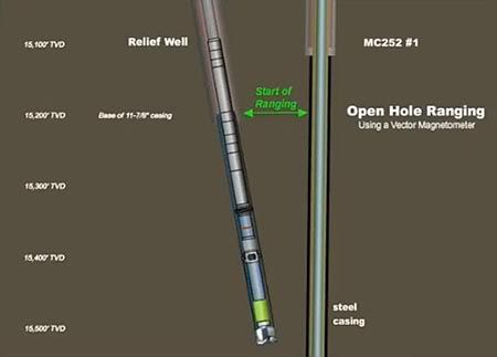
The initial approach above will be followed by open hole and drill pipe magnetic ranging. After they get within 5 feet of the blown out well's lower casing they will ream, case and cement the relief well prior to reaming through the blown well's casing. (Photos from The Oil Drum)
Audio, a slide presentation, and a transcript from Kent Wells' 6-28 briefing is available.
The video feeds we are watching:
==== ROV Feeds =====
44287/44668 - OceanInterventionROV1
44838/45135 - OceanInterventionROV2
46566/54013 - Viking_Poseidon_ROV1
55030/56646 - Viking_Poseidon_ROV2
31499/31500 - Boa_Deep_C_ROV_1
22458/23729 - Boa_Deep_C_ROV_2
45685/49182 - Skandi_ROV1
45683/45684 - Skandi_ROV2
47175/21144 - Enterprise_ROV_1
21145/21327 - Enterprise_ROV_2
37235/37270 - Q4000_ROV1
35523/35624 - Q4000_ROV2
Discovery Inspiration's ROV1 (24951)
HOS Adventure ROV1
HOS Adventure ROV2
Olympic Challenger's ROV1
Olympic Challenger's ROV2
Possibly outdated or redundant links (from The Oil Drum):
46245 - BP "Official" #1 (primary)
46260 - BP "Official" #2 (secondary)
46661 - BP mystery feed #1
46663 - BP mystery feed #2
Restricted to web browser based viewing:
CNN Video Streams Note: multi-view is sometimes unavailable.
PBS (fewer security issues than some others)
BP videos Links to all available live feeds from BP.
WKRG - Mobile/Pensacola (Contains link for an iPhone app at the bottom.)
ABC 7 Chicago Live Video Multiple ROV Camera Views (h/t to temptxan for the great find).
Multiple stream feeds (hard on browser/bandwidth):
The best multi-view feed Be patient as load time may take a bit.
Markey's multi-view page
Lusty's multi-feed page (originally created by papicek, but a huge improvement made by Lusty, who also kindly hosts it :^)
Vote For America's awesome clickable multi-view Courtesy of one of our very own Kossacks.
A multi-view Contains feeds from BP, C-SPAN-2, WKRG, and PBS
High-def video feeds
See this thread for more info on using video feeds and on linking to video feeds.
Again, to keep bandwidth down please do not post images or videos.
Links, courtesy of several Kossacks
ACTION
- X Prize Competition for oil spill fix announced
- Requiring a Relief Well: Let's Write a Bill! A diary series by Garret
- National Science Foundation rapid response research grants for Gulf oil spill research
- ERMA: Environmental Response Management Application
BACKGROUND
- Google Crisis Response page for Gulf Oil Spill
- Wikipedia: Deepwater Horizon oil spill
- BP has a good diagram of the cutting process that partially succeeded
DATA
- Sketch Map of Subsea Operations - from Another Kevin
- GeoPlatform - Gulf Response: Mapping the Response to BP Oil Spill in the Gulf of Mexico
- Kent Wells' technical update, June 10, 2010
- dov12348's oil toxicity links
- dov12348's Ocean currents, wind currents, and hurricane links
- Visualize the spill
- SkyTruth
- Images of the Oilpacalypse, from Tomtech.
- Visit the Oil Spill Crisis Map to see where oil, mousse, tar balls, and eau de crude have been reported on the Gulf coast.
- The BP Deepwater Horizon Unified Command official website. Wherein you can read latest post warning of employment scams associated with the event and much more from the folks handling this.
- Timeline of response here.
- Department of Energy BP Deepwater Horizon Spill site updates.
- Department of Interior BP Deepwater Horizon Response site provides updates, reports, data, links to pictures, etc.
- Rigzone for specific disaster news and news about the offshore industry, in general.
- Courtesy of profgoose here is a list of links from The Oil Drum links on newer developments, etc
- Maritime ship tracking -- courtesy of johnsonwax
- Map of things on the sea floor there. -- outdated, based on unreliable data
- Calculator for distance from BOP. -- not reliable
- NOAA Spill tracking site
HEALTH AND SAFETY
- 2010 Gulf Oil Spill Crisis Wiki
- NIH National Library of Medicine Crude oil spills and Health
- ATSDR (Agency for Toxic Substances & Disease Registry) Total Petroleum Hydrocarbons (TPH): ToxFAQs™
- CDC Emergency Preparedness and Response: 2010 Gulf of Mexico
Includes fact sheets and health and safety information for Gulf Coast Residents, Response Workers, and Health Professionals
- Reducing Occupational Exposures while Working with Dispersants During the Gulf Oil Spill Response
- EPA Response to BP Spill in the Gulf of Mexico
Includes Air Monitoring Data Reports, Daily Average Particulate Matter, Air Sampling Data Files, Real-time Air Monitoring (including TAGA data), and Downloadable data set of hourly air monitoring
LEGISLATION/FEDERAL RESPONSE
- Administration response to spill.
PERTINENT BLOGS and collections of Oil Spill-specific JOURNALISM
- The Daily Hurricane: Blog run by Bob Cavnar
- Nola.com Oil Spill News
- Sun Herald (Biloxi, MS) Oil Spill News
- Mobile (AL) Press-Register Oil Spill News
- St. Petersburg Times (FL) Oil Spill News
- World newspapers oil section
- The Oil Drum
- Oil & Gas Journal
- Offshore Magazine
- Petroleum News
- Your Oil and Gas News
- World Oil
- Bit Tooth Energy blog (technical discussions) by the famed Heading Out, well known key poster on The Oil Drum blog site.
WILDLIFE
- Help Cornell Lab of Ornithology collect bird information on the Gulf
- Center for Biological Diversity list of Gulf species threatened by the spill
- International Bird Rescue Research Center: Info on bird survival rates
- Summarized tally of affected wildlife
- US Fish & Wildlife Service Deepwater Horizon Oil Spill Response h/t to CindyMax Left side of page has "Daily Wildlife Collection Reports" that details wildlife found oiled, alive, deceased, and/or released.
- BP doesn't want photos of dead animals
- Washington Post: People Come Together to Save Coast's Oil-Covered Wildlife (h/t Humphrey)
Previous liveblog ROV diaries:
Daily Kos Gulf Watchers ROV #198 - BP's Gulf Catastrophe - gulfgal98
Daily Kos Gulf Watchers ROV #197 - BP's Gulf Catastrophe - khowell
Daily Kos Gulf Watchers ROV #196 - BP's Gulf Catastrophe - Gulf Watchers Overnight/peraspera
Daily Kos Gulf Watchers ROV #195 - BP's Gulf Catastrophe - Ekyprogressive
Daily Kos Gulf Watchers ROV #194 - BP's Gulf Catastrophe - CindyMax
Daily Kos Gulf Watchers ROV #193 - BP's Gulf Catastrophe - Kimberley
Daily Kos Gulf Watchers ROV #192 - BP's Gulf Catastrophe - Gulf Watchers Overnight/peraspera
Daily Kos Gulf Watchers ROV #191 - BP's Gulf Catastrophe - Yasuragi
Daily Kos Gulf Watchers ROV #190 - BP's Gulf Catastrophe - Twilight On The Beach Edition - Pam LaPier
Daily Kos Gulf Watchers ROV #189 - BP's Gulf Catastrophe - Yasuragi
Daily Kos Gulf Watchers ROV # 188 - BP's Gulf Catastrophe - Gulf Watchers Overnight/peraspera
Daily Kos Gulf Watchers ROV # 187 - BP's Gulf Catastrophe - Darryl House
Daily Kos Gulf Watchers ROV # 186 - BP's Gulf Catastrophe - khowell
Previous motherships and ROV's from this extensive live blog effort may be found here.
| | We Are Here |
| | We are here. |
| | We are watching. |
| | Years from now, |
| | if anyone asks, |
| | we will tell them: |
| | We were there. |
| | |
| | Maybe it will not matter. |
| | Maybe nothing matters. |
| | But if we throw up our hands now, |
| | maybe someday, |
| | years from now, |
| | we will ask ourselves, |
| | why did we not at least keep watch, |
| | why did we not? |
| | |
| | Maybe someday, some of us |
| | will talk with someone younger, |
| | and tell of the time we watched. |
| | Maybe that someone younger |
| | will try harder next time, |
| | will do more next time, |
| | remembering |
| | the time we watched. |
| | |
| | -- bigjacbigjacbigjac |
We're all stunned and horrified by this disaster. Huddling with good people to calculate the damage and monitor progress, have a laugh when we can, share the sorrow we feel, and learn a lot in the process... That's what I'm really here for.
This is how I best cope. And if it turns out to be a useful thing to others, then that's great.
Kimberley
This is where you want to be for discussion, worrying, tearing up, and caring for each other. It's also where you're welcome to be angry and scream and curse and cry and rant at the criminal negligence and greed that have brought us all together. Most importantly, though, it's where we can learn from those kossaks among us (I'll not name names for abject fear of leaving one of you out, but you know who you are.) who bring the light of knowledge - sometimes with heat, sometimes without it - and teach us about what's happening beneath our Gulf of Mexico. On a personal note, I'll ask you to please be kind to each other in our little boats. There's enough hurt going on outside without bringing it here. - khowell
-------------------
St. George Island sits on the south side of the Apalachee Bay, four miles off the mainland Gulf coast of north Florida. Much of this area is very rural and the largest town is Apalachicola. St. George Island is the largest and most developed of four barrier islands that protect the Bay and is the only one that is accessible by automobile. Two of the other islands, Cape St. George (or Little St. George Island) and St. Vincent Island, are uninhabited wildlife refuges that are only accessible by boat. The fourth island, Dog Island is under private ownership and contains a number of homes, but is only accessible by ferry.
Originally, ferry was the only way to access St. George Island also. In 1965, the first autombile access to the island was provided when the island causeway bridge was completed. Originally, it was a toll road and and later the toll booths were removed and access was free.
Not long after the causeway bridge was completed, birds began nesting on the causeway. The bird nesting populations were huge, and consisted of several species of terns, laughing gulls, and oytercatchers. Nearly every square inch of sand on the causeway was populated by bird nests, and juvenile birds would often wander onto the roadway. When I lived on the island, I dreaded what I called "dead bird" season. During nesting season, local boy scouts erected temporary soft mesh barriers along the causeway to protect the nests, but young birds still wandered onto the pavement. Even though the posted speed limit during nesting season was 15 miles per hour, many people ignored it and sped right through the causeway area, killing numerous birds. The carnage was horrific and the smell was over powering.
The causeway system was also problematic because of the tidal surges in the Bay often caused it to become flooded in even minor storms. For major storm event, the island had to be evacuated well in advance because the bridge was often shut down well in advance due to heavy waves crashing over the causeway. In 2002, the state of Florida let bids for a new bridge to replace the old causeway bridge. The new bridge was to be a single span of four miles in length, the third longest in Florida. It was also to be elevated several feet above the old bridge to accommodate storm tides.
In planning for the new bridge, the state moved its new location several hundred feet west of the old causeway bridge. After much negotiation with local residents, both on the mainland and on the island, the state agreed to keep a portion of the old bridge on each end for use as fishing piers. Finally, in response to environmental concerns, the state had the contractor remove the remaining bridge spans and all pilings, along with the pavement from the causeway. The causeway was to remain to protect the nesting grounds of all the seabirds that had been using it for the previous forty years. The old causeway is now designated as a Critical Wildlife Area by the state of Florida where seabirds nest in peace.
------------------
Bandwidth Warning: NO IMAGES and NO VIDEOS. Readers who are on DIALUP will thank you!
