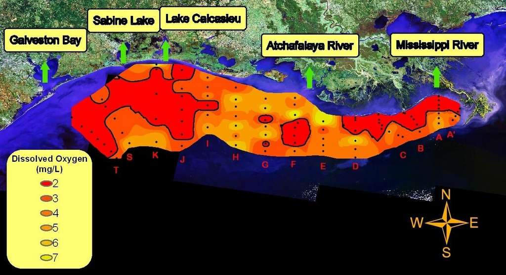
We will never know if this year's Gulf dead zone was the largest ever. The cruise sampling the Gulf was terminated in, apparently, the middle of a large dead zone, before it was fully sampled. PDF
"This is the largest such area off the upper Texas coast that we have found since we began this work in 1985." She commented that "The total area probably would have been the largest if we had had enough time to completely map the western part."
Oxygen concentration in bottom-water across the Louisiana-Texas shelf from July 25-31, 2010. The black line outlines values less than 2 mg/L, or hypoxia. Letters indicate transects. Black dots are sampled stations.
Hypoxia (low oxygen) correlates with fresh water near the Mississippi river, but not in the Texas dead zone.
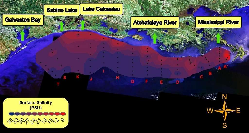

The dead zone off of Texas, where the sampling was terminated was highly unusual. It wasn't where it was expected, in the freshest water, enriched in nitrates and phosphates from the Mississippi river, like the dead zone just west of the delta. The dead zone in low salinity water just west of the delta was expected based on the heavy runoff from the Mississippi river.
The high biological productivity seen in surface waters to the west of the river was not unusual considering the prediction of size for 2010 and the continued flux of fresh water and nutrients from the river. "It would be difficult to link conditions seen this summer with oil from the BP spill," said Rabalais, "in either a positive or negative way." The slicks were not continuous over large areas for extended periods of time, which would be necessary to see the localized effects of toxicity or oxygen drawdown. Rabalais, who accidentally surfaced from a scuba dive into a surface oil slick in May, had seen miles and miles of phytoplankton thick waters before the slick moved in. "The Mississippi River nutrient-enhanced growth of phytoplankton is what fuels the hypoxic zone, and has for many years," she said.
It is very difficult to link conditions seen this summer with the spill given that the cruise was terminated before the hypoxic zone was fully sampled. Comparing this year with previous years is impossible.
It's like playing cards without a full deck.
On July 27 and 28, 2010 the MODIS satellites show the reflection of oil on both sides of the Mississippi river delta. A thorough scientific investigation would have sampled the oiled zone east of the Mississippi delta to see if there is an association between oil and hypoxia without the effects of river water.
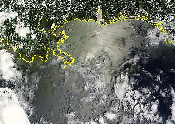
27 July 2010 The Terra MODIS satellite shows oil east of the Mississippi delta.
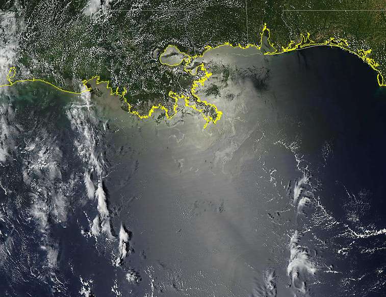
28 July 2010 Terra Satellite 1000m resolution
Storms in June and July and strong currents moved a large volume of oil from the BP spill towards Texas and deep into the Gulf of Mexico.
Shiny streamers of oil reflect silvery light in the central Gulf on 25 July 2010 as shown by the Terra satellite.
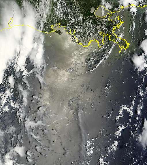
On July 17, 2010 the Terra satellite showed a large area of iron stained water with silvery oil slicks extending from Galveston bay deep into the Gulf of Mexico. This water was likely a mixture of BP oil, Mississippi river fresh water and Gulf of Mexico water. The shiny area mixed with clouds in the central Gulf that is not iron stained may be a low wind area not affected by oil.
The key to identifying oil here is the combination of iron staining and silvery slick reflections.

The iron stained water is like the clue right before your eyes that you can use to solve the case of the Texas dead zone. The relatively high salinity levels of the water indicate that nitrate fertilizers have been diluted by sea water. Mississippi river water concentrations diluted too much by sea water off of Galveston Bay to explain the huge dead zone. Likewise, the oil from the BP gusher is diluted by sea water and river water. Chemical dispersants have also been highly diluted.
The iron from the BP spill is the likely cause of the Texas dead zone in salty water.
Iron is known to be a limiting nutrient in the deep ocean. Surface waters, including Mississippi river water, contain very little dissolved iron because atmospheric oxygen reacts with soluble iron to make insoluble rust {ferrihydrite - Fe(OH)3}. However, oil bearing formations are anoxic. Under anoxic conditions, iron is quite soluble in salty water. That's why the oil spill is red, not black. The dissolved iron coming up with the oil turns to red rust (ferrihydrite) when exposed to the atmosphere.
The dead zone in the salty water in the deep Gulf off of Galveston is more closely associated with iron from the oil spill than nitrate levels because nitrate fertilizer levels should directly correlate with low salinity. It is clear from the both the MODIS imagery and location of the dead zone that both BP oil and Mississippi river water were transported offshore of Texas by currents.
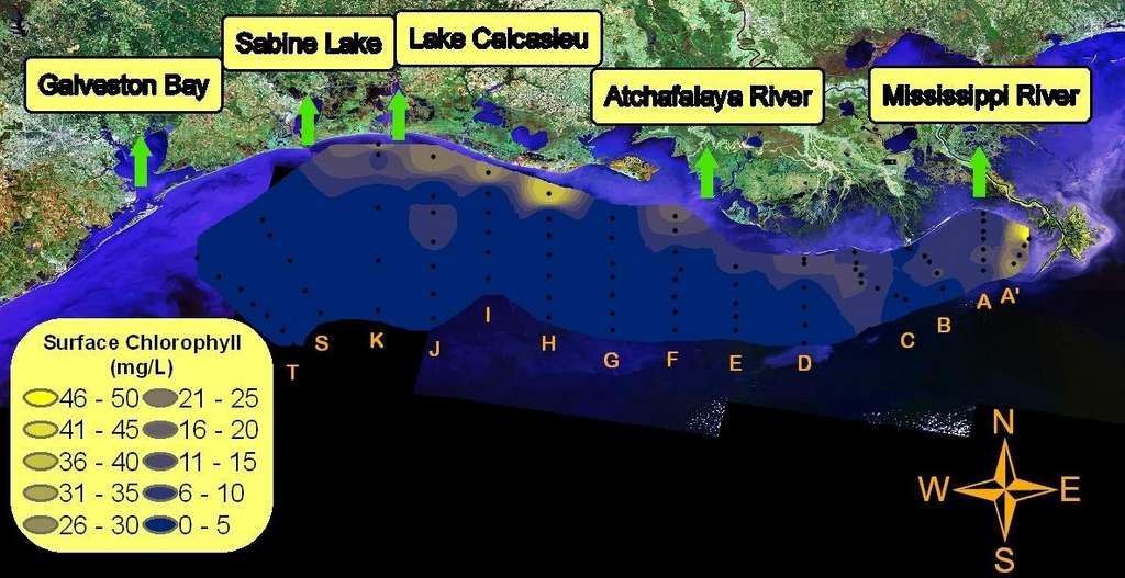
The Texas Gulf dead zone does not correlate well with chlorophyll levels in water. Chlorophyll levels correlate with the dead zone near the Mississippi delta.
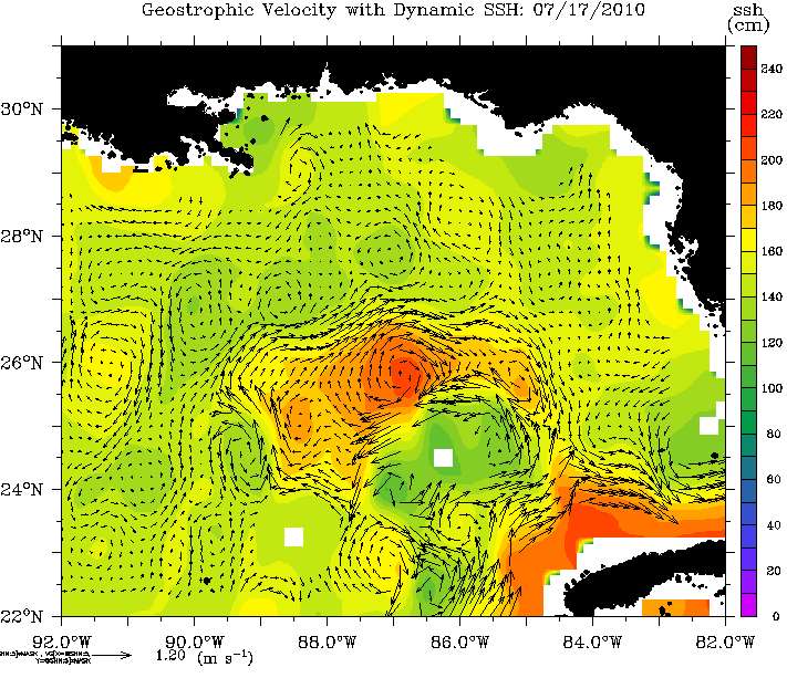
Oceanographic models show that currents took Mississippi river water in the Gulf towads Texas.
The good news that no more oil is entering the Gulf is a cause for a brief quiet celebration....then getting back to work to study and mitigate the effects of the huge amounts of oil that remain in the Gulf. The recent NOAA press release, that most of the oil is gone or too dilute to be of concern, is not based on sound scientific evidence. NOAA has consistently overlooked oil that currents took west off the Texas coastline. There is solid scientific evidence that certain toxic components of oil - polycyclic aromatic hydrocarbons - can bioaccumulate. And there is voluminous evidence showing that iron can fertilize sea water, potentially causing oxygen depletion. Dispersed oil may still be toxic.
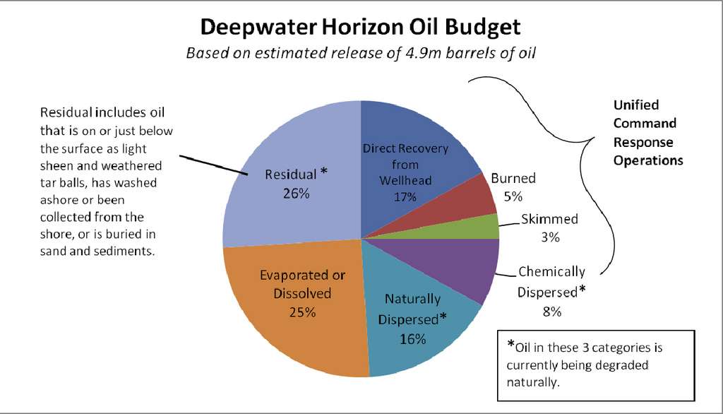
Federal report on fate of the BP oil, summary.
The vast majority of the oil from the BP oil spill has either evaporated or been burned, skimmed, recovered from the wellhead or dispersed much of which is in the process of being degraded. A significant amount of this is the direct result of the robust federal response efforts.
NOAA's rosy report has been questioned by scientists who have studied other oil spills.
The scientists and other experts who challenged the government's conclusions warned that painting too rosy a picture could hamper the environmental monitoring and cleanup work that remains to be done in the Gulf.
Marine conservationist Rick Steiner, a retired University of Alaska scientist, said: "Let's look at this another way: that there's some 50 percent of the oil left. It's still there in the environment."
The government report also fails to account for the effect of vast, underwater plumes of microscopic droplets of oil that remain unmeasured, scientists said, and it downplays the potential long-term effects of the release of as much as 4.1 million barrels of oil in the Gulf of Mexico. Some 800,000 barrels were captured at the wellhead.
The remaining 50 percent in the water is the equivalent of almost eight Exxon Valdez oil spills, until now the country's benchmark environmental disaster.
"Now what we're hearing is they don't think the damage will be as bad as they initially thought," Steiner said. "We have to remember that the same thing was said after the Exxon Valdez. But much of the damage didn't become apparent until the second or third year."
Storms hid oil just below the surface on a number of beaches. Oil buried in the sands and marshes and hidden below the water's surface will continue to affect the environment for years.
