After taking some suggestions in my previous diary, I have decided to go back to my last West Virginia Congressional map and make what is to be my magnum opus on the matter. It is also probably the most pretty of my WV maps to date with each district compacted. What I eneded up with is an effective, but socio-geographically logical Congressional gerrymander.
More below the fold.
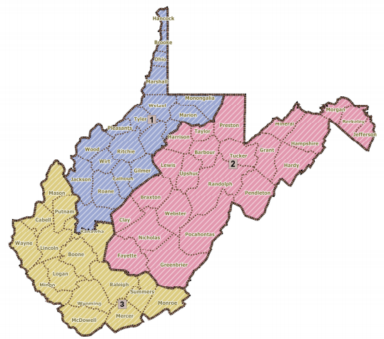
In response to two critiques, I have done a revision to my West Virginia Congressional map. Now that I know that it is not Kosher to put Marion and Monongalia Counties in separate districts, I have put them both in WV-02. However, I had to expand WV-01 in response to this subtraction by giving it Wirt, Ritchie, Gilmer, Braxton, and Lewis Counties. The positive consequence of this is that Shelley Moore Capito's home of Charleston is now even further distanced from WV-02. To get WV-03 closer to zero deviation, I gave it back Webster County and took out Pocahontas County. I also labeled the general areas that each Representative calls home.

WV-02 now makes a ton more geographic sense in this incarcation. Eastern West Virginia can now finally elect one of their own. WV-02 is no longer a stripe that ventures from Jefferson County in the far east to Mason County at the far west.
WV-01 in this form is roughly as Democratic as it is under the map used in the 2000's. WV-02 is made less Democratic, but one that still went fairly comfortably for Democrat Joe Manchin (of the two-party vote alone, he got 52% here) over Republican John Raese. Population-wise, WV-02 is anchored by rapidly-growing Monongalia County (the location of Morgantown and West Virginia University) and rapidly-growing Berkeley and Jefferson Counties. WV-03 becomes slightly bluer.
Finally, in this new map, I decided to do a tiny bit of county-splitting to get close to zero deviation since WV-02 would have had an excess of 2000+ people if I stuck to whole county districts. I just took a sliver from Upshur County and a nibble from Pocahontas County, nothing earth-shattering.
This map is probably the kind that West Virginia Democrats could use to sweep all three districts in 2012.
Statistics:
WV-01 (red): 54.3% Manchin, 45.7% Raese; deviation from ideal population of +2
WV-02 (white): 52% Manchin, 48% Raese; deviation from ideal population of -7
WV-03 (blue): 59.75% Manchin, 40.25% Raese; deviation from ideal population of +4
4:07 PM PT: The first official draft of West Virginia's Congressional map is up in the State Senate: http://blogs.wvgazette.com/...
The map itself: http://www.legis.state.wv.us/...
It draws together Capito and McKinley and does the controversial action of splitting Kanawha County.
4:32 PM PT: MilesC has the approximate Manchin/Raese statistics for the districts in the official draft here: http://www.dailykos.com/...
4:45 PM PT: Keep in mind that this is merely a draft. Not a great map, but not a bad map either.