Update 8am EDT 24August
The National hurricane center (NHC) upgraded Irene to a 115mph (100kt) category 3 hurricane at 8am this morning. The NHC has adjusted the forecast landfall slightly east into the middle of Long Island, NY, then curving inland into Connecticut, Rhode Island and Massachusetts.
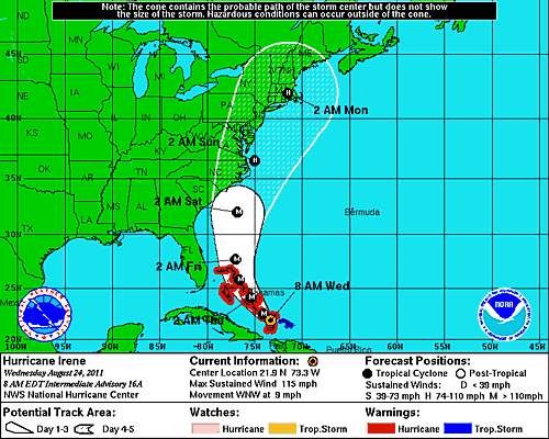
NHC FORECAST POSITIONS AND MAX WINDS
INIT 24/0900Z 21.6N 72.9W 95 KT 110 MPH
12H 24/1800Z 22.5N 74.1W 105 KT 120 MPH
24H 25/0600Z 24.1N 75.4W 110 KT 125 MPH
36H 25/1800Z 25.8N 76.6W 110 KT 125 MPH
48H 26/0600Z 27.7N 77.0W 110 KT 125 MPH
72H 27/0600Z 32.0N 76.8W 105 KT 120 MPH
96H 28/0600Z 36.5N 75.0W 90 KT 105 MPH
120H 29/0600Z 42.0N 71.5W 70 KT 80 MPH...INLAND
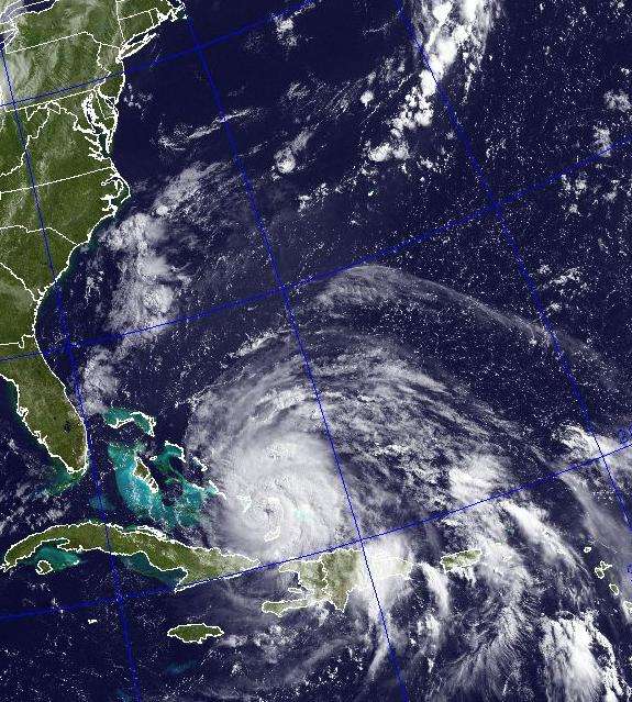
12:45Z 24Aug2011, Vis/Ir Image in public domain courtesy of US Navy
end update
...............................................................................................................
Microwave satellite imagery shows that Irene intensified rapidly this evening after moving away from the high island of Hispanola. A tight eye formed surrounded by very cold cloud tops in the eyewall.
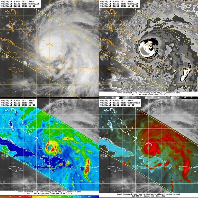
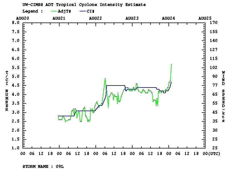
The objective Dvorak method, a computerized way of determining the wind speed of a hurricane, shows that Irene is in the process of becoming a major hurricane.
The eastward shift in Irene's forecast track towards Hatteras Island is great relief for almost everyone in the Carolinas, but it will likely spell a multi-billion dollar disaster for areas further north from the mid-Atlantic to New York to southern New England. The present NHC forecast track takes Irene inland into the Jersey shore south of New York city on a path that will focus a large storm surge and large tides and swells on the Battery of New York City. Damage from surging water in the Battery could be staggering.
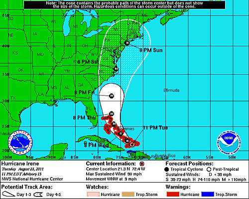
11 PM EDT 23August2011 NHC Forecast
However, if Irene deviates left of this forecast after Hatteras, it could head up Chesapeake bay affecting Virginia Beach, Norfolk and Baltimore. If it deviates right it could demolish the Hamptons, some of the priciest beachfront on the planet, or it could swamp the historic "cottages" of Newport Rhode Island. There is no low cost deviation, short of going east of Cape Cod, if Irene maintains hurricane intensity.
The National Hurricane Center's 11pm forecast is on virtually the same track 5pm forecast. On this track, Irene is likely to cause massive damage to New York harbor unless it weakens rapidly north of Cape Hatteras.
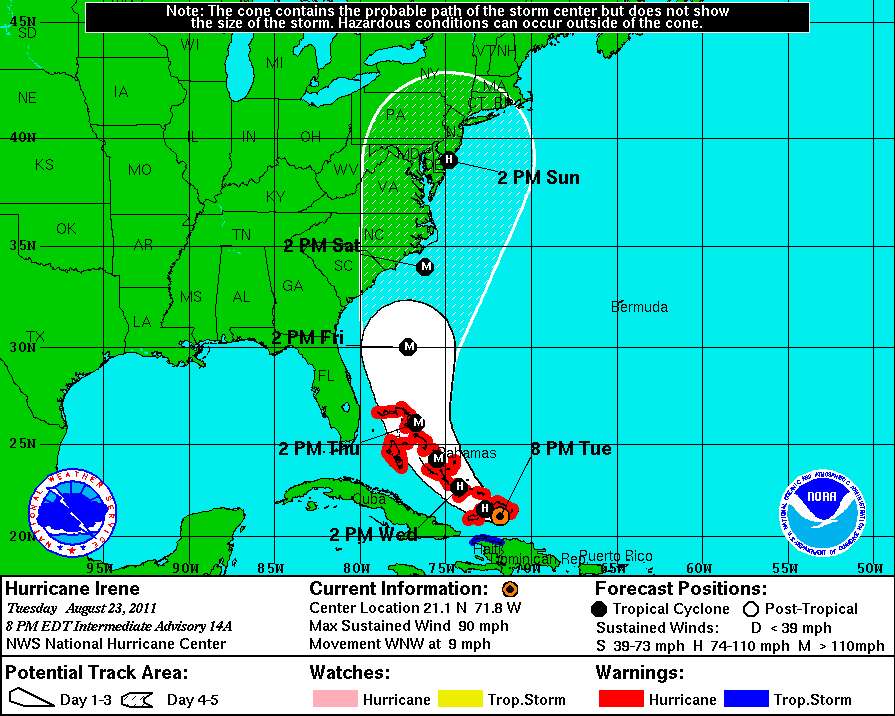
5PM EDT 23Aug2011 NHC Forecast
The Latest Model runs came out tonight after the NHC's forecast for 18Z (GMT) Tuesday
from Clark Evans' web site
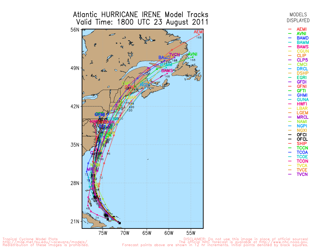
Most of the tracks in these model runs also would cause massive damage if Irene stays strong. The NOGAPS model, which was a poor performer last year, takes Irene east of Cape Cod.
The most reliable models forecast tracks for Irene that are likely to bring massive monetary damages.
The NHC explains storm surges.
| Introduction
Along the coast, storm surge is often the greatest threat to life and property from a hurricane. In the past, large death tolls have resulted from the rise of the ocean associated with many of the major hurricanes that have made landfall. Hurricane Katrina (2005) is a prime example of the damage and devastation that can be caused by surge. At least 1500 persons lost their lives during Katrina and many of those deaths occurred directly, or indirectly, as a result of storm surge.
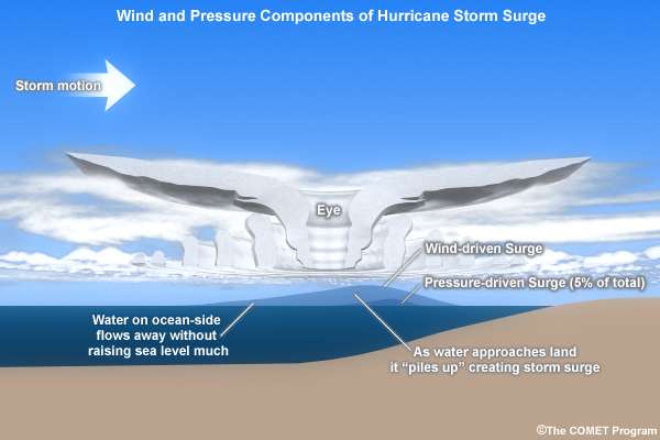
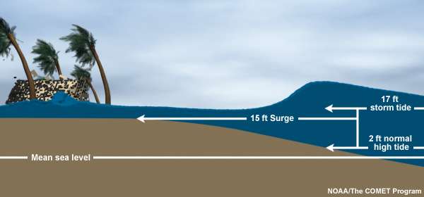
Storm Surge vs. Storm Tide
Storm surge is an abnormal rise of water generated by a storm, over and above the predicted astronomical tides. Storm surge should not be confused with storm tide, which is defined as the water level rise due to the combination of storm surge and the astronomical tide. This rise in water level can cause extreme flooding in coastal areas particularly when storm surge coincides with normal high tide, resulting in storm tides reaching up to 20 feet or more in some cases.
|
Irene is on a track similar to the model storm in this figure taken from a report by MIT published in 2010 (hat tip to Jeff Masters & Weather Underground)MIT paper, PDF Because of the funneling shape of the coastline, New York harbor builds up a large storm surge when a storm tracks towards the Jersey shore or the Hudson River.
| The 1821 (ed text says 1921) hurricane struck NYC directly, producing a 4.0 m (13 ft) “wall of water,” which flooded lower Manhattan as far north as Canal Street. The “Long Island Express” of 1938 produced flood heights of 3.0–3.5 m (10–12 ft) in Long Island and up to 5.2 m (17 ft) in southern New England, killing as many as 700 people. Hurricane Donna of 1960 produced the 2.55 m (8.36 ft) highest recorded water level at the Battery and flooded lower Manhattan to West and Cortland Streets. In addition to hurricane storm surge, New York City is also highly vulnerable to extratropical storm surge and sea level rise, especially considering that much of the seawall that protects lower Manhattan is only about 1.5 m above mean sea level [Colle et al., 2008].
|
For a professional meteorologist's analysis from 11am today please see Millwx's report.
Here.
