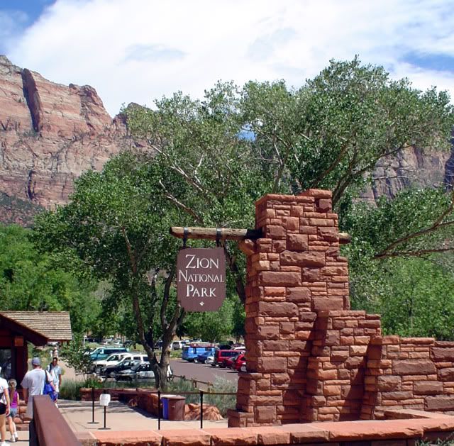
Zion National Park was the first national park located in Utah. Located adjacent to the town of Springdale, Utah, the park contains 229 square miles (590 square kilometers) of protected land. The main feature of the park is Zion Canyon, a 15-mile canyon that is up to half a mile deep in spots, cut by the North Fork of the Virgin River.
I've been visiting Zion on a more or less annual basis since 2004. It is one of my favorite national parks, and each time I go back, I find something new about it to love. I'm so glad to be able to share it with you. Follow me below the fold for some more information and more pictures.
Zion is a study in contrasts. Located at the junction of the Colorado Plateau, the Great Basin, and the Mojave Desert, the park contains many and varied geographical features, flora and fauna, and climate zones (desert, riparian, woodland, and coniferous forest). Zion's geography includes mountains, canyons, buttes, mesas, monoliths, rivers, slot canyons, and natural arches. The lowest elevation in the park, at Coalpits Wash, is 3,666 feet (1,117 meters); the highest elevation, at Horse Ranch Mountain, is 8,726 feet (2,660 meters). Temperatures in the park vary from season to season, and also with changes in elevation and location. There may be a difference of 30 °F or more between day and evening temperatures at the same location. Last year, Zion had 2,665,972 visitors, good enough for 28th overall out of all National Park Service locations, and accounting for just shy of 1% of the NPS visitor total. The five-year average for visits to Zion ending in 2010 was 2,663,232.
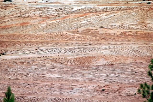
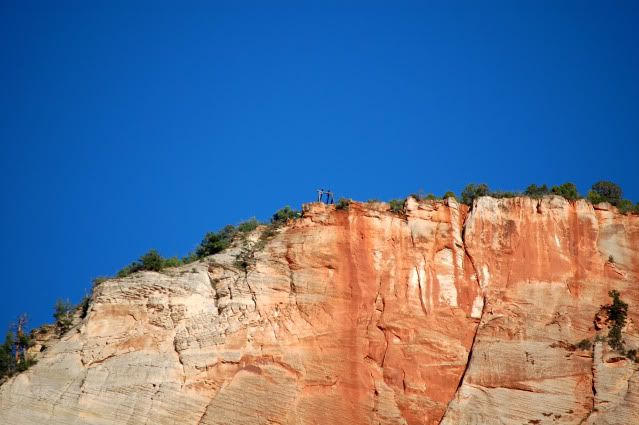
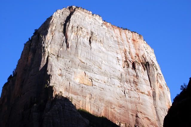
Rock face on the Upper Kolob Plateau, showing coloration and stratigraphy in the Navajo sandstone formations.
History
Almost 12,000 years ago, Zion's first peoples tracked mammoth, giant sloth, and camel across southern Utah. Due to climate changes and overhunting, these animals died out about 8,000 years ago and humans living in the area adapted their lifestyle to focus on gathering foods and hunting mid-sized animals. As resources in the area continued to dwindle, a farming tradition centered on Zion developed, which archaeologists call the Virgin Anasazi. The image here (taken near Big Bend last summer) shows the remains of what was probably a granary used by the Anasazi people at some time during their occupation of the area, which began around 300 CE.
Anasazi-era structure, probably a granary, located near Big Bend.
Zion's geology offers a combination that is rare in the desert region surrounding the canyon: a wide, level place to grow food, a river to water it, and an adequate growing season. On the Colorado Plateau, crops grow best between 5,000 and 7,000 feet. Zion's elevation spread (from 3,666 to 8,726 feet) is almost ideal for this purpose. Differences in elevation encourage diverse plants and animals, allowing the natives to vary their diet without too much effort (and probably also to survive in years when crops or hunting were sparse for whatever reason). The Anasazi left the area and headed southeast approximately 800 years ago, probably due to drought and over-cultivation. Not long afterward, the Southern Paiute moved into the area, and thrived.
Two Spanish missionaries, Silvestre Vélez de Escalante and Francisco Atanasío Domínguez, came through southern Utah in the late 18th century. They passed near what is now the Kolob Canyons Visitor Center on October 13, 1776, becoming the first Europeans known to have visited the area. Trapper Jedediah Smith, under contract to the American Fur Company, explored some of the canyon's downstream areas in 1825.
In 1847, Mormon farmers from around Salt Lake were the first people of European descent to settle in the Virgin River region. By 1851, these settlers had pushed to Parowan and Cedar City, and named the area Kolob, after the star located closest to the throne of God in Mormon cosmography. Early settlers used the Kolob Canyons area for supplies of timber and also to graze their cattle, sheep, and horses. They diverted waters from the Kolob region to irrigate crops in the valley below, and began prospecting for minerals.
By 1858, Mormon settlements had pushed the 30 miles south from Cedar City to the lower Virgin River. In that year, a Southern Paiute guide led Nephi Johnson, a Mormon missionary and interpreter, to the upper Virgin River area and Zion Canyon proper. He wrote a favorable report back to Salt Lake City about the area’s agricultural prospects, and founded the nearby town of Virgin. The floor of Zion Canyon itself was settled in 1863 by Isaac Behunin, who farmed corn, tobacco, and fruit trees in the area. He and his family lived in the canyon during the summer growing season (near the site of what is now Zion Lodge), and spent the winters in Springdale. Farming in the canyon continued until the 1909 designation as a national monument.
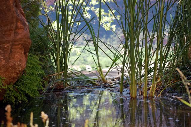
View of the Middle Emerald Pool, looking back out into Zion Canyon proper.
John Wesley Powell’s geographic expedition entered the area in 1869, after making their first trip through the Grand Canyon. Powell himself visited the canyon in 1872 and gave it the name "Mukuntuweap," which he thought was a Paiute name meaning "straight canyon." Survey photographers began photographing the area in the spring of 1872, and one of them, John K. Hillers, came back the following year for more. Frederick S. Dellenbaugh painted views of the canyon and exhibited them at the St. Louis World's Fair in 1904.
Scribner's Magazine did a feature on the park in 1905, all of which contributed to the decision, by President William Howard Taft, to create the Mukuntuweap National Monument on July 31, 1909, as a means of protecting the canyon. The name Mukuntuweap proved highly unpopular in the area, and on a visit to the canyon in 1917, Stephen T. Mather (appointed as the first director of the newly created National Park Service) proposed changing the name of the park to Zion. The name is an alternative in Hebrew for the city of Jerusalem, and in Mormon tradition is used to designate a place of safety and refuge. That name stuck, and on November 19, 1919, the U.S. Congress added additional land to the former national monument and declared it Zion National Park. Two days after FDR’s second inaugural, on January 22, 1937, Congress declared the Kolob Canyons area to the north and west of the main park a separate Zion National Monument. This area was subsequently incorporated into the park proper on July 11, 1956.
Travel to Zion was difficult during its national monument days. The park is located in a remote area, and there were few real roads in southern Utah at the time the park was first established. Old wagon trails began to be converted to automobile roads beginning around 1910; the road into Zion Canyon proper was constructed in 1917, reaching as far as the Grotto. That summer was the first time that touring cars could easily reach Zion, and accordingly, Wylie Camp, the first lodging accommodation was established in the canyon in that year.
In 1923, Wylie Camp was acquired by the Utah Parks Company, a subsidiary of the Union Pacific Railroad. The UPRR and Utah Parks began offering ten-day rail-and-bus tours to Zion, and also to Bryce Canyon, Kaibab, and the North Rim of the Grand Canyon. Two years later in 1925, Zion Lodge was built in the canyon at the site of the former Wylie Camp. The lodge was designed in the "rustic" style by architect Gilbert Stanley Underwood, who was also responsible for the lodges at the Grand Canyon and Bryce. The developers wanted a large hotel, to boost revenues. The director of the NPS, on the other hand, wanted a smaller footprint, so a compromise was worked out between the two.
The original Zion Lodge was completely destroyed by fire in 1966. It was rebuilt within 100 days of the disaster, but lost most of its original rustic appearance due to the need to expedite the reopening. A 1990 remodeling restored the original look, but provided many modern conveniences and also reduced the lodge’s ecological footprint.
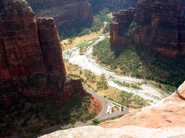
View from Scout Lookout of Zion Canyon and the Virgin River.
Work began in 1927 on the Zion-Mount Carmel Highway, to provide reliable access between Springdale and areas on the east side of the park. The road opened in 1930, which greatly increased park visits and generally boosted travel in the area. The road’s most famous feature is the 1.1-mile Zion-Mt. Carmel Tunnel (which was under heavy renovation/reconstruction last summer, but which seems to be fully open this season—at least there wasn’t anything in the spring 2011 park newsletter about closures or restrictions: still, it might be advisable to check, especially if you’re going to be pulling a camper or traveling in an RV or other large vehicle—there are always restrictions on those for the tunnel).
In 1896, local rancher John Winder improved the native footpath up Echo Canyon, which later became the East Rim Trail. Teen-aged entrepreneur David Flanigan used this same trail in 1900 to build cableworks that lowered lumber from the top of Cable Mountain to the canyon floor (and took workers in the opposite direction; if you look carefully, you can see the remains of part of the cable works in the photograph below). Flanigan got the cable, if my recollection is correct, as surplus from one of the telegraph companies. At the time, the closest source for good timber for building purposes was Kaibab in Arizona, which was a long and dangerous trip by mule train. Flanigan’s company brought down more than 200,000 board feet of lumber from the top of the mountain by 1906, and he sold the company just before the development of the area roads made the work of bringing the lumber down the mountain unprofitable.
Remnants of the cable works atop Cable Mountain
The canyon road was subsequently extended to the Temple of Sinawava, and a trail (the Riverside Walk) was built from that point one mile further down-canyon, to the start of the Narrows. Beginning in 1926, the Angels Landing trail was constructed, including the stunning (and strenuous) section of 21 short switchbacks known as "Walter's Wiggles," after Walter Ruesch, the first superintendent of the park. Two suspension bridges over the Virgin River were also added. The Civilian Conservation Corps constructed further trails during the 1930s.
In March 2009, President Barack Obama signed the Omnibus Public Land Management Act into law. This act designated and further protected an additional 124,406 acres (503.5 square kilometers) of park land as the Zion Wilderness.
Geography, Features, Access
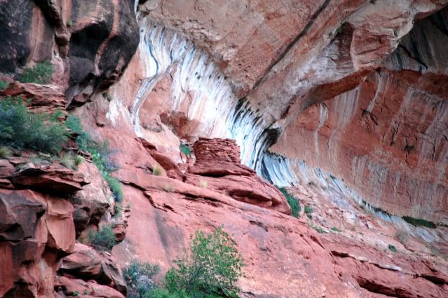
The road into Zion Canyon is six miles (9.7 kilometers) long, ending at the Temple of Sinawava, which is named for a Paiute deity ("Coyote"), who played the role of a trickster in the native religion. At the Temple, the canyon narrows and the Riverside Walk is an easy, reasonably level one-mile walk that proceeds up-canyon to the Narrows. The Narrows is a gorge that is only accessible through the riverbed. At its narrowest point, the gorge is only 20 feet (6 meters) wide, and up to 2,000 feet (610 meters) tall.
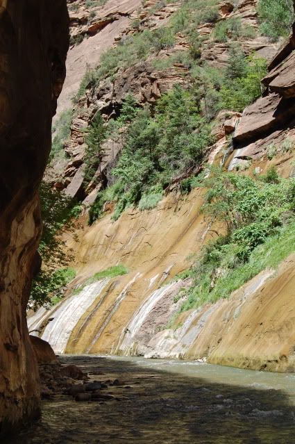
Waterfall near the beginning of the Virgin River Narrows.
During the peak visitor season (April 1 to October 30), the Zion Canyon Road is served by a free shuttle service, and private vehicles are barred from most of the road unless they have a pass for Zion Lodge. Shuttle buses run on propane, beginning at 6:45 a.m. (5:45 from May 22 through September 10) through 10 p.m. (11 p.m. in the summer) in the park, and approximately 10 minutes earlier (or later, for return trips) in the town of Springdale. The average wait for a shuttle is 15 minutes or less (less during peak hours). In the summers after dark, shuttles in the park run at 30-minute intervals. There are nine stops in the canyon proper; beginning at the Visitor's Center they are, proceeding up-canyon, the Zion Human History Museum, Canyon Junction (the point beyond which private vehicles are not allowed without a lodge pass in the summer), the Court of the Patriarchs, Zion Lodge, the Grotto, Weeping Rock, Big Bend, and the Temple of Sinawava. A round-trip on the shuttle takes about 80 minutes; riders are free to get on or off at any stop (just be sure to pay attention to whether the bus is heading up- or down-canyon!). Parking at the Visitor's Center is limited, and fills up quickly, so either plan an early start, or find parking at one of the many free parking areas near a shuttle stop in Springdale and catch the next bus into the park. Other park roads are open to private vehicles all year (with some restrictions for the Zion-Mount Carmel Highway and its tunnel).
The east side of the park is served by that highway, which passes through the Zion-Mount Carmel Tunnel and ends at Mount Carmel Junction. Notable features in this part of the park include Checkerboard Mesa and the East Temple. The Kolob Terrace area west and north of the main park features the Subway, a slot-canyon hike, and Lava Point, which features a panoramic view of the entire area. Kolob Canyons, located directly off Interstate 15 (exit 40) further west toward Cedar City, features Kolob Arch, one of the world's longest.
Weather
Weather in the spring is unpredictable; stormy, wet days are common, though occasionally mixed with warmer, sunnier weather. Precipitation is heaviest in March. Spring wildflowers bloom from April through June, peaking in May. Fall days are usually clear and mild, with cool nights. Summer days are hot (95 °F to 110 °F, 35 °C to 43 °C), but overnight temperatures are milder (65 °F to 70 °F, 18 °C to 21 °C). Afternoon thunderstorms are common from mid-July through mid-September, and may produce local waterfalls as well as flash floods (a major consideration in deciding whether or not to attempt the Narrows).
Autumn color displays begin in September in the high country; colors within the canyon proper usually peak in late October. Winter in the canyon is fairly mild, with storms bringing rain or light snow to Zion Canyon, with heavier snow at higher elevations. Clear days may be warm, up to 60 °F (16 °C), with night-time temperatures of 20 °F (-7 °C) to 40 °F (4 °C). Winter storms can last for several days and make roads icy. Roads in the park are plowed, except the Kolob Terrace Road, which closes when covered with snow. Winter driving conditions last from November through March. This is reflected in the visitor statistics, which are lowest in the winter months (November through February), and peak in the summer (July and August being the busiest, with upwards of 10,000 visitors per day at the height of the season).
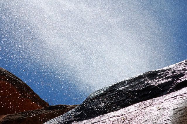
Waterfall along the Lower Emerald Pools trail. (Actually shot from behind, looking upward and out. I just love this shot!)
Accommodations
In the park, there are three campgrounds: Watchman (185 sites, and the only one that takes reservations), located near the park entrance and the Visitor's Center; South (126 sites), located a little further up-canyon, not far from the Human History Museum; and Lava Point (6 sites), in the backcountry at the junction of the West Rim and Wildcat Canyon trails. Group campsites (7) are also available. All campgrounds have restrooms, drinking water, picnic tables, fire grates, and dump stations--but no showers. Private campgrounds with showers and hookups are available in Springdale. South Campground is closed from late November through early March, and during that time Watchman Campground operates on a first-come, first-serve basis. No laundry facilities are available within the park, but can be found in Springdale, Hurricane, and Kanab.
The only other in-park accommodations are at Zion Lodge, which is managed by Xanterra for the Park Service. The lodge has guest rooms, suites, some cabins, a gift shop, a full-service restaurant, and a cafe. Lodging is also available in Springdale, Rockville, Hurricane, near the east entrance to the park, at Mt. Carmel Junction, in Kanab, St. George, Cedar City, and other surrounding communities. Speaking from personal experience, you will have a much more enjoyable visit--and be able to partake of a much wider range of activities--if you stay in the park proper or just outside. It's about a 40-minute drive from Cedar City, for example, assuming the roads are open and conditions are good. It's not impossible, but it will limit some of your options.
Reservations for both the campground and the Lodge go quickly, so be sure to plan in advance. Campground reservations at Watchman can be made up to six months in advance. Reservations at the lodge can be made up to a year in advance (and if you're planning a visit during the peak summer months, that's probably a good idea).
Pets are allowed in the park as long as they are on a leash no more than six feet in length. They can be walked along the Pa'rus Trail, but are not permitted on any other trails, on shuttles, in public buildings, or in the backcountry. Boarding kennels are available in Rockville, Kanab, Hurricane, St. George, and Cedar City.
As previously noted, there is a full-service restaurant and a cafe in Zion Lodge. Reservations are required for dinner only in the lodge dining room; seating at other meals is on a first-come, first-serve basis. There are numerous restaurants available in Springdale, just outside the park proper (I personally recommend the Bit and Spur which, despite its name, serves very nice Southwest fusion cuisine: the sweet potato tamales are excellent.), and also farther away.
Things to Do
It would take another whole diary to describe everything that can be done in Zion. Indeed, it might be easier to list the things that can't be--it wouldn't be a very long list.
Among the most popular activities in Zion, hiking is easily the biggest. The park has nearly 20 designated hiking trails, ranging from easy to super-strenuous. You can go out for an entire day, or just hop off the shuttle, walk for a bit, and then catch another shuttle to another spot. One of the more strenuous hikes (but also among the most popular) is Angels Landing. It's so popular, there's actually a T-shirt in the gift shop you can buy after you've done it. The photograph above of the canyon and the Virgin River was taken at Scout Lookout, the next-to-last stop on that hike. (I didn't go all the way up to Angels Landing, though my best friend did.) To get a sense of what's involved, check out the "eHike" on the park's multimedia page.
Other recreational activities include bicycling (only allowed on roadways and the Pa'rus Trail), rock climbing, and horseback riding. Watercraft are only allowed in the backcountry, and only at times when the river is flowing at more than 140 cubic feet per second. Inner tubes are not permitted on any park watercourses, though there are several companies that offer tube rides on the Virgin River in Springdale and elsewhere along the river.
If you're staying in the park, either at Zion Lodge or in one of the campgrounds, wait until dark, and then catch a shuttle up to Big Bend. You can lie back on one of the shelter benches, walls, or even the sidewalk (you might want to bring a pillow or a blanket) and, once the shuttle leaves, you've got a half an hour of total darkness to do some awesome stargazing or night photography. My buddy and I did it twice last summer, and we saw a ton of meteorites as well as a view of the Milky Way that you just can't find in too many places in the United States anymore, thanks to the ubiquitous problem of light pollution.
I highly recommend the ranger-led activities, especially the twice-daily "Ride with a Ranger" programs. In fact, I can't recommend them enough. I've learned so much from the rangers over the years, it's definitely a highlight of the experience. The photograph below was taken on a "Ride with a Ranger" trip last summer. It's a roughly two-hour shuttle bus tour, led by one of the park rangers. Each one is different, so you may want to take more than one. It's free, but reservations are required and can be made (in person) at the Visitor's Center up to one day in advance.
The Great White Throne at sunset.
If you're going to be in the area during the season, the
Utah Shakespeare Festival, which is celebrating its 50th year this summer, is outstanding. The festival performs all of the Shakespeare plays in rotation, and adds in modern works that vary from year to year. Most of the plays are staged in an outdoor theater reminiscent of Shakespeare's Globe. Cedar City, where the festival is located, is home to Southern Utah University (which houses the festival), and is about a 40-minute drive away from Zion proper. I don't recommend trying to mix theater and Zion, however; do one first and then the other--it's much more enjoyable.
If you do get to Cedar City, I heartily recommend the Garden House for dinner (164 South 100 West, Cedar City, UT 84720; 435-586-6110; reservations recommended). And if you're looking for other things to do from Cedar City as a starting point, you should head north out of town and check out the Parowan Gap petroglyphs. They're about a 15-mile drive out of town, and well worth a visit. Great Basin National Park in Nevada is a couple of hours away by car, but well worth a day trip. Other nearby national parks include Cedar Breaks National Monument (an afternoon or day trip), Bryce Canyon (worth a trip--and a diary--of its own) in Utah, and the North Rim of the Grand Canyon in Arizona. There is also the Grand Staircase-Escalante National Monument, which is managed by the Bureau of Land Management.
If you have a four-wheel drive or other high-clearance vehicle, you may want to consider a trip along the Kolob Reservoir Road, which cuts through the northwestern portion of Zion proper, proceeding over both the Lower and Upper Kolob plateaus. One terminus of the road is off of Utah 9 just outside of Virgin; the other is on Utah 14, just outside of Cedar City. The road is paved at its beginning and end, but not in the middle. There are some drop-offs and rough spots, but at least in summer it's usually passable. The photograph below was taken near Urie Creek along the Kolob Reservoir Road, at an elevation of around 9,000 feet.
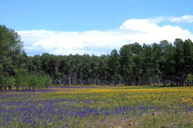
Wildflowers along the Kolob Reservoir Road near Urie Creek.
One thing always to keep in mind in Zion--or any other wilderness area--and that's to be careful. As I was writing this diary, I caught a story on my Twitter feed: two hikers went missing in Zion after filing a backcountry hiking plan. Stay on the designated trails, beware of wildlife, and always make sure someone knows where you're planning to go. Cell service is very spotty in and around Zion, so it may not be possible to call for help. (P.S.: I'm glad to say the story has a happy ending;the missing hikers were found and airlifted out April 19.)
Resources
Zion's National Park Service web site. (They also have a Twitter feed.)
Zion Lodge information.
Five things you "must see" in Zion, from the Travel Channel.
Zion Canyon Visitors Bureau
Sources
Zion National Park website; Wikipedia; National Park Service statistics; Spring 2011 Map and Guide; A Century of Sanctuary, 1909-2009, official centennial newsletter.
This has been the ninth in a series of user contributed features on the national parks. Our previous features are:
- Jackson Hole National Monument
- Fort McHenry National Monument and Historic Shrine
- Capitol Reef National Park
- Petrified Forest National Park
- Sequoia and Kings Canyon National Parks
- Dry Tortugas National Park
- Wind Cave National Park & Jewel Cave National Monument
- Death Valley National Park
If you are interested in writing a feature about a park, please volunteer at our sign up form and as your window approaches, you'll be contacted (about 3 weeks before) to finalize your date.Updated by craigkg at Thu Apr 21, 2011 at 01:17 PM CDT
Just a note on next week's park feature, I had to ask someone to pinch hit for us as the original poster scheduled wasn't going to be able to contribute. Our feature next week will be on Saguaro National Park in the southern desert of Arizona, contributed by tnaskedov. Thanks tnaskedov!
Updated by musing85 at Tue Apr 26, 2011 at 02:26 PM CDT
The park administration has just announced that there will again be road construction along parts of the Zion-Mt. Carmel Highway from Canyon Junction to the east entrance of the park, beginning April 26. Work is scheduled Monday through Thursday from 7 a.m. to 5 p.m. and is expected to be completed by mid-May.
If this work is as heavy and involved as what was going on last summer, it's going to mean it's probably a good idea to avoid the Zion-Mt. Carmel Highway at all during the construction phase--the road will be in very rough shape, there will be tons of construction vehicles entering and leaving and using the road, and there will be considerable traffic slowdowns and/or delays. Check with the park staff before you go for the latest information.