Apologies for the late posting today. I had to make a quaint little trip down to the E.R. to tend to some nasty complications from recent ankle surgery. That'll teach me not to snap my ankle off playing ice hockey. Doh!
Anyway, Irene jumped a bit north yesterday... just a center re-formation, not a motion. But her future track direction also has a slightly more northward component of motion than previously anticipated... just slightly, not a major track shift. But it is enough to create some critical forecast changes... mostly not in the positive direction for the U.S. (though there is a chance Hispaniola could be spared the worst now). Below the fold for more...
The northward shift in the models is not entirely seen in the National Hurricane Center forecast yet, but that's probably partially because of the time I'm writing this... just prior to the new NHC forecast. Their last one looks like this:
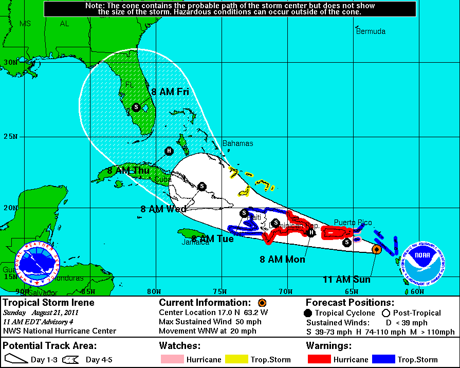
...but a new forecast is due out shortly and I'd encourage you to visit the NHC site (link above) for their latest track. I can't be certain they'll shift the track north. Some computer guidance is still pretty far west (the UKMET model, for example, still sweeps Irene into the eastern Gulf of Mexico). But most guidance has shifted to the north and east with a slightly weaker Atlantic ridge (storms go around ridges of high pressure... a weaker ridge means it is smaller and buldges out less; since this ridge is centered to the northeast of Irene, this means it will push her less to the southwest. So, the NHC will probably nudge the track to the north a little.
This is great news for Hispaniola... assuming this adjustment is correct of course. The current forecast (shown above) carries Irene right down the spine of the island. The flooding this would induce could be catastrophic. By going to the north of the island, or even along the northern edge of the island the impact will be much less. Most certainly there will still be some torrential downpours, especially in orographically enhancing areas. But check out what Irene looks like:

...It's probably reasonably evident to you that the center of the storm is somewhere around 18N latitude right now. Check out the convection on that map (evidenced by the deep red colors). Most of it lies to the north of the storm center. Unless this changes, if Irene tracks near the northern edge of Hispaniola it will keep the worst of the rainfall out over the open Atlantic waters, sparing those two nations some massive problems. That would also spare Cuba, who was also in the line of fire given the above forecast.
However, this is not good news for the U.S. If Irene can keep her center just offshore of Hispaniola it will mean little or no weakening. And even if the center tracks inland, if it's right along the coast Irene's core structure could remain intact, allowing for more substantial/rapid intensification after she emerges from the island.
Moreover, with that more northward turn, most computer guidance models now keep her offshore of Florida - not showing landfall until South Carolina. That would keep her offshore longer, allowing for more intensification - assuming upper level conditions allow for it. And, unfortunately, they probably will. Sometimes with a northward turn, since it's the result of a cold front, upper level winds increase and shear can inhibit intensification (or even induce weakening). But these fronts passing by to the north (there's more than one) do not do a good job reaching down to Irene. Rather, they do just enough to break through the ridge and allow Irene to turn.
Here's what a number of these models look like:

Though this doesn't look like a major consensus towards the Carolinas, there are more models than shown on this map. The tropical guidance suite issued by NHC, which contains some statistical guidance, is almost universally bullseyed on South Carolina (with one of the five members on either side). The Euro model is also focused towards a South Carolina landfall. So is the Japanese JMA model. The Canadian model is further east, showing no landfall at all, but with a close enough shave to Cape Cod that warnings would be warranted for all of SE New England. That model can be viewed as something of a counterpoint to the two more western solutions (UKMET and GFDL). Incidentally, the timing of landfall is just over five days away on most of these models... that would be late Friday (maybe early Saturday).
As for intensity, this more over-water track unfortunately leaves the door open for more intensification. Here's what the models show on that:

(Courtesy of Brian Tang's great site.) The most striking thing about this is that the usually best performing of these models are the highest ones on the list... though the HWRF does have a notorious high bias, thankfully. And don't be fooled by that late GFDL drop-off, that's due to its more westward track inducing a Florida landfall. So, the most superior models have Irene on the cusp of Category 3 by Day 5. And with most of those continuing an upward slope at the end of the period, and landfall coming post-120hrs, there's an outside chance (if these models are even correct in the first place, of course... a major caveat) that Irene makes it to Category 4 by landfall. That would be devastating... Cat 4s are a rarity on the East Coast (north of Florida).
My own take? Well, I cannot see going against this strong model consensus. I'm tempted to hedge even a bit east of them, since that's been the strong trend the last 24 hours. But with none of these troughs (cold fronts) strong enough to make a great sweeping grab for Irene, I'm hard-pressed to go with a more abrupt turn. So, I'm going straight with the model consensus. This should allow Irene to clip eastern Hispaniola - enough to stall development and induce brief weakening, but not enough to severely disrupt the storm. Then I think the storm strengthens significantly coming through the southern and western Bahamas as it makes a slow turn to the north. Eventually, Irene - again, just in my own personal assessment... subject to change (a meteorologist's favorite phrase :) !!) - should head up towards the South Carolina coast and make landfall on Friday as a Category 2 or 3 hurricane. (I am allowing for Category 2 because, even though most reliable solutions show Cat 3, Irene has been struggling to pull herself together and organize more over the past 12-24 hours... sometimes when storms struggle like this, it is a permanent feature with that storm; bluntly, I have no clue why, it would seem like ideal conditions surrounding the storm should force intensification... but it doesn't work that way; plus, I don't want to underestimate the impact of Hispaniola on Irene).
Let me re-emphasize that this is a very early first guess. Even a slight westward jog could yield landfall in Florida (I think Irene may get dangerously close to south Florida before making that turn). On the flip side, any continued (and assumedly correct) trending to the east and NC could be the bullseye. And if NC is the bullseye, further up the coast could also be threatened if Irene slips back offshore near the Virginia Capes. So, everyone on the entire Eastern Seaboard needs to watch Irene closely. Stay tuned!
**NOTE: As I finish this up, the new National Hurricane Center forecast is out and they have nudged the track north a bit. But they are on the western side of the models, as they readily admit. So, they still have significant land interaction with Hispaniola - so their intensity forecast hasn't changed much.
