The projected path and other parameters of Hurricane Isaac are similar enough to this actual planning scenario to pique the interest of any weather hound I think. Fortunately, should worse come to worse, the good people of Tampa, working together with Government (ahem) did build this;
Hurricane Phoenix is a fictitious storm created to simulate the effects of a worst‐case scenario. With input from Tampa Bay area emergency management agencies and the local office of the National Weather Service (NWS), a simulated storm was developed with a track and intensity that would devastate the entire Tampa Bay region. The NWS generated National Hurricane Center advisories, local hurricane statements, and data
More frequent and more powerful Hurricanes are one of the most inevitable consequences of climate change, and I bear the poeple of Tampa no ill will, but dayum, a
biblical Isaac visiting itself upon the very folks who claim that such things are the consequence of an angry God and not of the actions of willful humans might want to set up an
appeasement and meteorological diversion prayer chain post haste.
Fortunately Federal, State and local government is on the stick, prepared for the worst case scenario, bacon-saving plan in place;
1.2 Scenario Timeline for Hurricane Phoenix
October 7 – A tropical depression forms west of the Lesser
Antilles, moving generally westward.
October 9 – The depression reaches tropical storm
strength…named Tropical Storm Phoenix.
October 10 – Phoenix reaches hurricane intensity south of Jamaica…forecast to strengthen
slightly as it moves generally west and west‐northwest into the Yucatan Straits.
The storm is forecast to be over open water in the central Gulf of Mexico in 5 days.
The entire eastern Gulf coast from New Orleans to the Florida Keys is on the edge
of the 5‐day error cone (Forecast Map 1). Forecasters, as well as the public, have a
wait‐and‐see attitude for a “minor” hurricane that hasn’t yet set its sights on
particular location for landfall in the U.S.
October 12 – The Tampa Bay region’s hurricane preparation kicks into high gear as the forecast
track turns more to the east with each National Hurricane Center (NHC)
forecast/advisory.
Now, to my untrained eye October 12 as noted above looks enough like
August 24, today that one wonders what precautions are being taken already.
Update at 3 p.m. ET. In its latest update, the National Hurricane Center says that tropical storm Isaac "could be near hurricane strength" when it reaches Haiti later today. That's a slightly more serious forecast from where we began the day
As for where Isaac is headed, it will likely blow over Cuba this weekend and then through the Florida Keys and South Florida. The latest projected path now puts it on a course to perhaps give Tampa — site of next week's Republican National Convention — at least a glancing blow. But Isaac looks to be headed more toward the Florida Panhandle, and the coasts of Alabama, Mississippi and perhaps Louisiana.
As the hard done by peoples of Haiti and Cuba are battening down their hatches, the GOP is oiling up their own. They should expect
at least a glancing blow and so should remember both to close the hatch in rain and not to let the
tongue dangle too far out it lest a mere glancing blow evolve into a rather unfortunate auto-lingual amputation. Good news though, there seems to be a
'Plan B'. And, as a final ellipsis, is the name of
the caterer for the convention mere coincidence? I don't think so.
Orlando's Puff 'n Stuff catering is preparing for the Republican National Convention
Follow the updates on this unfolding story beyond the fold.
Sun Aug 26, 2012 at 12:45 AM PT: Night 1 of RNC cancelled due to Hurricane Isaac
LA Times
The giant storm is forecast to pass close enough to the Tampa area to deliver a battering of rain and tropical-storm-force winds of 39 to 73 mph, starting as early as Sunday night and continuing through Monday. A gala welcome party for 20,000 convention participants, scheduled for Sunday evening, was still on as of Saturday night.
Thousands of the GOP delegates and other convention participants are being housed in resort hotels along a coastal barrier island that is expected to bear the brunt of the storm in the Tampa-St. Petersburg area. They will be advised as early as Sunday morning if it will be necessary to evacuate to higher ground inland, officials said.
Romney is scheduled to deliver his acceptance speech at the convention arena in Tampa on Thursday night. The tropical storm is forecast to be out of the area by Tuesday evening. That presumably would give organizers enough time to salvage at least the final two days of the convention, unless there is widespread damage.
For several days, party officials and Florida Gov. Rick Scott, a Republican, have sought to play down the potential weather threat to the convention and steadfastly refused to discuss contingencies.
"Here's the deal. We'll know on Monday how severe this tropical storm is," Republican National Committee Chairman Reince Priebus said on a conference call. "We're not going to put delegates on a bunch of buses over the bridges between Clearwater and St. Pete when we can't predict how severe the wind is going to be and how severe the damage might be."
Only the day before, Priebus had said he was breathing easier about any possible cancellation and expressed optimism that the event would go off without a hitch.
While we laugh at yet another unforced Repug error, lets keep it in mind that a whole bunch of our Brothers and Sister in deep damn Dixie are about to get a whuppin, again.
That aside, I'm buying popcorn. I feel like a Nascar fan, just waiting for the next big wreck. and, I'll be updating this diary for my own edification if no other reason.
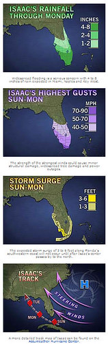
Graphical View of Isaac's Predicted Impacts on Florida as of 8/25
Its going to be a bumpy night.
