Pearlescent blue clouds mysteriously appeared in far northern latitudes after the eruption of Krakatoa in Indonesia. Perhaps these noctilucent clouds existed before the massive eruption threw enormous quantities of sulfurous vapors into the stratosphere. Perhaps the bright sunsets that attracted millions of eyes resulted in the wispy ultra high clouds finally being noticed. Perhaps. But why then are these strange clouds spreading south? Why are clouds once seen only in places far to the north such as Norway and Finland now being seen as far south as Colorado?
On June 13, 2012, when this image was taken from the space station as it passed over the Tibetan Plateau, polar mesospheric clouds were also visible to aircraft flying over Canada. In addition to the still image above, the station crew took a time-lapse image sequence of polar mesospheric clouds several days earlier on June 5, while passing over western Asia. It is first such sequence of images of the phenomena taken from orbit.
Polar mesospheric clouds form between 47 to 53 miles (76 to 85 kilometers) above Earth’s surface when there is sufficient water vapor at these high altitudes to freeze into ice crystals. The clouds are illuminated by the sun when it is just below the visible horizon, lending them their night-shining properties. In addition to the polar mesospheric clouds trending across the center of the image, lower layers of the atmosphere are also illuminated. The lowest layer of the atmosphere visible in this image--the stratosphere--is indicated by dim orange and red tones near the horizon.
Electric blue clouds, literally at the edge of space, have been recently seen glowing in the dark from Oregon to Colorado to Virginia, further south than they have ever been seen. Until the last several decades they were always seen north of 50 N Latitude. No one is sure why the clouds are moving south but global warming is a suspected cause.

Image created by NASA
Noctilucent clouds form at exceedingly cold temperatures around negative 125 Celsius, 50 to 100km (30 to 60 miles) above the earth's surface, in the mesosphere. The atmosphere is one hundred million times drier than the Sahara desert, but clouds form because the temperature is so low. They are seen in midsummer when the moisture from the stratosphere (the layer below the mesosphere) is known to upwell into the mesosphere. One other likely source of water is upwelling methane gas. Methane is broken down by UV and high energy radiation to generate hydrogen gas which reacts with oxygen to form water. Material from incoming meteors may also add both tiny particles needed to seed the clouds and ice particles which vaporize. Powerful volcanic eruptions may also add particles that nucleate ice.
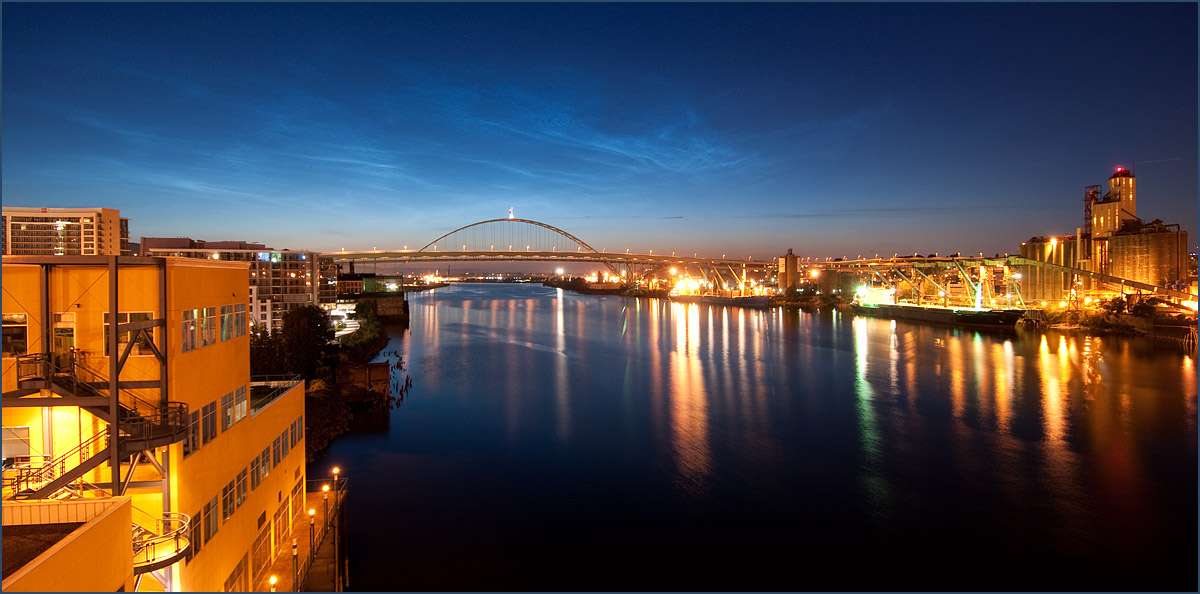
Noctilucent clouds over Portland by VictorVonSalsa Portland, Oregon 15July09
Less venting of natural gas from oil wells led to slowing of the growth rate of atmospheric methane from 1985 to 2007. The perfect match of methane levels to ethane levels during that period is the clue that ties the decline to oil and gas production activities. Natural processes do not release methane and ethane in tandem as oil and gas production does. In 2007 Arctic sea ice suffered a catastrophic decline and increases in Arctic methane levels were observed.
Sea ice extent and area declined catastrophically in 2007. Since that sudden decline increasing levels of methane have been observed in the atmosphere above the Arctic ocean. Permafrost has also melted in increasing quantities with the warming of the Arctic and the melting of the sea ice. The loss of ice greatly darkens the Arctic and amplifies the warming. There are many agricultural sources of methane but none of them suddenly changed in 2007. The sudden change in methane/ethane in 2007 correlates directly with the loss of sea ice.
Natural processes work to remove methane in the tropics and warm temperate areas. Those processes are not active in the polar regions. Thus methane in the rises up in the lower atmosphere because it is very light and becomes more concentrated as it rises up in the Arctic than in the tropics. This figure shows the growth of methane in the lower atmosphere from 2008 to 2011. Some of this methane rises to the middle and upper layers of the atmosphere.
Extremely low temperatures at the top of the lower atmosphere trap water vapor that rises up in the form of icy cirrus clouds, so the stratosphere is extremely dry. Methane, however, passes through the cold trap into the stratosphere. When it reaches the upper atmosphere, it is oxidized by energetic particles and oxygen to CO2 plus water. Meteors burning up in the upper atmosphere creates a very thin smoke. The water may then freeze onto fine particulates formed from meteor smoke to create noctilucent clouds if the conditions are right.
Professor James Russell has proposed that increasing amounts of methane escaping to the upper atmosphere are causing noctilucent clouds to brighten and spread further south
The inner solar system is littered with meteoroids of all shapes and sizes—from asteroid-sized chunks of rock to microscopic specks of dust. Every day Earth scoops up tons of the material, mostly the small stuff. When meteoroids hit our atmosphere and burn up, they leave behind a haze of tiny particles suspended 70 km to 100 km above Earth's surface.
Inside the meteor smoke zone, at a height of 83 km, so-called noctilucent clouds can occur, describes a NASA article. Meteor dust is the nucleating agent around which such clouds form. Specks of meteor smoke act as gathering points where water molecules can assemble themselves and grow into ice crystals to sizes ranging from 20 to 70 nanometers.
While noctilucent clouds appear most often at Arctic latitudes, they have been sighted in recent years as far south as Colorado, Utah and Nebraska. Question is: Why are the clouds brightening and spreading?
Prof. James Russell of Hampton University believes that more in methane in the atmosphere is causing this. Russell explains: "When methane makes its way into the upper atmosphere, it is oxidized by a complex series of reactions to form water vapor. This extra water vapor is then available to grow ice crystals for noctilucent clouds."
In conclusion, this greater occurrence of octilucent clouds is an indication that more methane is escaping into the upper atmosphere.


