Kindly Note: This is the second of three diaries posted under the same title. Mea culpa, for this addendum will be a tad longer than the first, though more detailed. (Hence, a need to indulge the patience of DKos readers.) There are also quite a few FYI's herein. Ergo, optional reading (for some interests). Anyway, grab a mug of coffee, tea or brandy and let's go back to the Glen of yesterday and today. Let's also remember what's at stake given the impetus of these diaries: It is horrifying we have to fight our own government to save the environment. (Ansel Adams) Indeed, sir! (P.S. I am adding the finishing touches to this diary on the day before the so-called end of days, that Mayan Calendar misinformation and business. Ergo, if you're reading this, then it looks like we'll all pull through until the next hoax is perpetrated by some seriously misguided people. Then again, negative news tends to outdo the positive.)
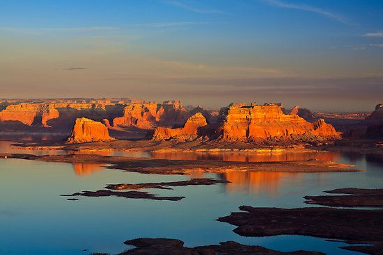
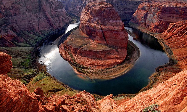
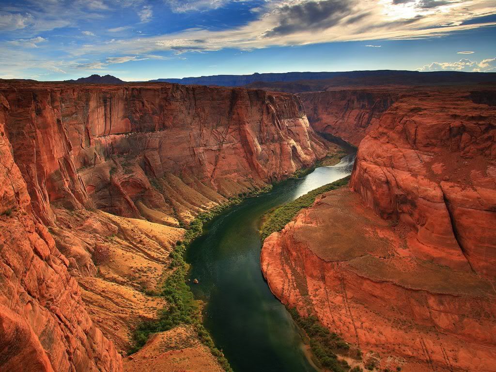
Prologue: Lake Powell. The Glen Canyon Dam. Glen Canyon. The Colorado River Storage Project Act. Floyd Dominy. The Bureau of Reclamation. David Brower. The Sierra Club. Tourism and Page, Arizona. Aggradation. Houseboat vacation rentals. Dead Pool. These designates are all relevant to Glen Canyon's afterlife phase. The fabled lines, "It was the best of times, it was the worst of times. . ." is a fitting way to describe what happened here not too long ago, only instead of A Tale of Two Cities reference, there is a fostered tale of two disparate settings and perspectives that sees things quite differently. The other part of this celebrated novel's opening words is equally apropos: ". . .it was the age of wisdom, it was the age of foolishness, it was the spring of hope, it was the winter of despair, we had everything before us, we had nothing before us, we were all going direct to heaven, we were all going direct the other way. . ." Indeed, Charles Dickens simile of the two cities suggests to me, at least, the old Glen Canyon city has nothing in common with the new Glen Canyon-Lake Powell city complex. Some see the changeover as analogous to Heaven on Earth, while others see it as a foolish waste of a pristine habitat. Thus the winter of despair protestors (at the time) begrudgingly had to accept as a major loss. What really pissed these people off was the fact this modest appearing canyon-abode may not have competed or compared with the likes of the Grand Canyon's magisterial showcase. (For instance, its picturesque stepped canyon profile created by differential erosion that had formed a series of cliffs, slopes and ledges almost from the rim to the river.) However, what the Glen did not showcase given her upper chestnut, beige and bronze-tinctured facade, she nevertheless sculpted the most extraordinary array of interior niches––those myriad glens, grottoes and cavernous chambers––all ensconced in side canyon drainages, like sinuous tentacles reaching toward that muddy and indolent river that birthed this domain.
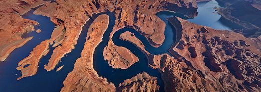
Verily, there is no other canyon in the entire Colorado Plateau Province that comes close to what the Glen's environs featured. None whatsoever! Dare I say there is no canyon on the planet that rivals her setting?
As we all know, this exclusive no man's land (due to the sparsity of roads at the time) ended up an every man's land. With the Glen's interior inundated by a very large lake, whose usually azure sheen seems like a chimera, and certainly a mirage in a desert sandstone country, the bold architects came in force, as did the engineers to interpret the blueprints, who then instructed a brigade of helmeted workers to carry out the task, the dirty, dangerous work. According to the Book of Genesis, what God created in seven days, this combined force of labor was equally impressive in a relative sense: a mere ten or so years to erect the stupendous structure, then wait another twenty or so years until the basin reached full pool elevation (3,700 feet above sea level). And there at the southwest sector, a rather handsome bridge was also built across the beguiled Colorado River. With its fairly tapered tongue of water lapping out below the dam, this afterthought of a body of water carried very little sediment in a moderately paced current. It really was a pitiful sight considering its emasculation assured by the great facade of that gleaming off-white barrier that stood in its way. Strangely, the changeover of a canyon environs to basin storage ordered by the Bureau of Reclamation, and spearheaded by two U. S. Senators, was the beginning of the end for the Glen. It was also the beginning of an emerging higher consciousness spawned by an eco awareness, the likes of which still surprises some people today how an impassioned fraternity of citizens would come to the rescue of a drowned Eden-in-sandstone. Glen Canyon, our lady in the lake as it were, some of us have never forgotten you! Like a beacon of hope, a supportive rank and file came from all points of the compass, even from beyond America's borders. Perhaps more surprising is the fact over fifty years later so many of us still protest what happened here.
For antichrist eco warriors, like Ed Abbey, here was another stimulus to a new movement that helped promote awareness, albeit this outspoken curmudgeon's more radical style environmentalism was later downplayed, just because. (Abbey's notorious literary works had nonetheless served a purpose.) Combined, these voices, deceased or living, are among the growing chorale that continues shouting down the dam in view of what Dominy’s blue jewel of the Colorado had covered up. The bottom line: What Glen Canyon connoisseurs today espouse as the most pristine canyon of them all has unequivocally retained her charm and grace. Arguably, the Glen's transformation is therefore not permanent.
Let it also be said this opening salvo and recapitulation is not a typical tirade generated by sore losers who could not save this virginal setting from an engineered drowning. The legacy of the affair not only signals the end of all big dam-building projects throughout the Colorado River's upper and lower basin, but more importantly stimulates an ideology of a reevaluation geared for preserving open spaces at all costs. Given hindsight, Glen Canyon should never have been targeted for basin storage, as though its turf was little more than an opportune and propitiatory prize. Indeed, when all the rigamarole is sorted out the reason why the Bureau of Wrecklamation (sic) came here to do its undertaking was because this canyon was a handy surrogate exchange of dam sites; a tit (Echo Lake) for a tat change of locale.
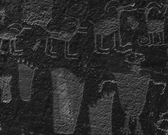
Be that as it may. . .let us mosey on and delve more deeply into the bureau’s chance stratagems that muscled its way into a previously unmolested fractal territory that practically shouted “Save me, for I have no national park or monument status!” Besides, the Glen, apart from her exalted and tangible assets, had always been a necropolis to prehistoric and historic native people who lived and farmed within this sandstone shelter for well over a thousand years. Eventually, these prehistoric and historic dwellers transpired from Form to Formless, leaving only archaic tools, dwellings and glyphs (rock art) portraying a long term occupancy. The physical loss of such a consequential record is incomprehensible and denotes human impiety. Would anyone really dare to violate any cemetery anywhere for whatever reason? The question is intentionally moot. (This diary continues after the fold.)
The Showy Deacon Who Could: What Floyd Elgin Dominy hoped to achieve with his spirited sermons on the (dam) mount to an admiring public, David Ross Brower and his incensed pro conservative guard listening and watching from afar were equally determined to thwart rumors of the BOR's latest plans to continue erecting more dams in this vicinity. As it turned out, the plans were real and the infusion of funds was already flowing Dominy's cocksure way. Thus that open conduit of money was even more hemorrhaging for a ranging and tortuous topography eyed for further exploitation. In this case, more damn (sic) basin storage. His determination in the matter also endorses the apt phrase––a done deal!

From the archetypal commissioner’s perspective, there was no other place to anchor these allocated cement plugs intended for deep water basins. He thought so anyway. To carry out his relished intent, Dominy's seeming and wanton insolence for this canyon country eventually risked violating a sanctioned national park that separated the two largest artificial basins in America. Guess where? In his own mystifying way, the big man running the helm of the BOR must have thought he had more sand than the predominantly sandstone country he had invaded, which was impeded by, if you will excuse the misuse of Latin, Giganitus Erectus Damicus. Some critics claimed this latest edifice was Dominy’s provisional lingam. And so, he considered his really was the biggest and everyone bowed down before him/it. Let us pray!
(FYI: Dominy! You either loved the man or considered him the grinch that stole the canyon country. I once heard him speak at a mixed gathering, meaning there were supporters and embittered folks in the audience. At one point, and responding to one lake-enthused supporter, the two-part question was how long the basin might last, and could he (Dominy) project some ideas about Page’s watering hole and its likely billion-dollar industry in the making? The commissioner estimated figure was typically boastful, though enshrouded in the mystique of declaring Lake Powell would likely be around for many generations to come. He also casually mentioned how everyone will enjoy the pretty playground behind the dam's protective wall (more or less his words). Besides, what else are unprotected canyons good for anyway? I mean, besides this stuff. . .

Well, someone else in another audience once interrupted the reverie of Dominy's usual gloating by stating the basin is bound to get clogged with too much crap (silt), and so what did the bureau have to say about that? This time Dominy was cheeky when he admonished “. . . .Let future generations worry about the problem!” But his droll retort was not well received as he hoped. It must have been a deadfall silence in that crowd, and some of whom might have thought an improvised neck tie party was in order. Even Brower had once posed a similar question by asking the commissioner, “Why leave our problems for future generations to solve?” Remarkably, Brower, unlike Abbey and his band of eco malcontents, wasn’t interested in dismantling or destroying the dam. Instead, he wanted to draw down the lake, clean out the residue debris, but let the dam stand as an anomaly and reminder of what his generation created as a literal monument to stupidity. Meanwhile, the Colorado River would make a slight detour in a new diversionary channel. Besides this reason and reminder, Brower and others of his persuasion thought the dam should never have been constructed in the first place and it was only fitting to leave the damn thing standing in the sense of an environmental ridicule. On this note, a profound statement of Rachel Carson is worth recalling: The more clearly we can focus our attention on the wonders and realities of the universe about us, the less taste we shall have for destruction.)

Getting back to that previously torpedoed Echo Park project on the Green River, which had quickly turned into a disconcerting pyrrhic victory for Brower and the gang, it was a shock to the senses what Dominy sought as a replacement dam site. Still, when the mind-numbing effects cleared from that bombshell, Brower dug in and commenced a new round of polemics, with the commissioner still bragging about his (that) thing he erected (figuratively speaking). While Brower had admitted he had personally assumed too much by anticipating another victory (at Glen Canyon before its downfall), Dominy was assured the impending new projects on a different river would not fail. And the first surely proved his case. By the way, this is Echo Park today: an alleged bait and switch site (or so it would seem a slick deal had come about out of nowhere).
Question: Had that clamorous group of protesters continued their fight a little longer, what then? Moreover, had a stronger voice cried out to the BOR––Qui Vive!––and enticed others involved in this cautionary plea not to bottleneck the Glen’s fragile frontier with a playground reservoir. . . again to state the concern, what then? Well, the question may be rhetorical but it still remains a curiosity, as well as salient speculation. Hence, how did the bureau, the largest wholesaler of water in the country, consider a quid pro quo of Glen Canyon’s remodeled semblance, a major facelift as it were? Whatever oratory and glory Dominy had preached from his cement-made pulpit (during and after the official commissioning of the dam), some folks in those congregations foresaw a calculated attack on two entirely different environments. In the final analysis, there would be no positive outcome (i.e., the essence of Dominy’s sassy spiels).
This part of the Glen Canyon long-running narrative is more than interesting, for it suggests here is where Brower’s earlier charge of collusion (by the bureau) is disclosed. The story goes like this. . .
What we lost by the dam hunkered down in this upper sector of the Colorado River’s drainage has turned out to be an irreplaceable exchange of a secluded habitat, which none of the project engineers and bureaucratic overseers had ever set foot into its graceful confines. Had they done so their minds and hearts surely would have posed second guessing to what was about to happen by their hand and deed. Even the Scarecrow who sought out the Wizard of Oz for a brain would have had better sense! Meanwhile, so much for wishful thinking, for reality can often be biting. But first came a very loud noise. . .dust and smoke that billowed high into the atmosphere from ground zero. It wasn’t the awe-inspiring glow and fire seen at New Mexico’s Trinity site in 1945, yet in a way the non radioactive fallout from the detonation at Glen Canyon has served to prevent another kind of war that was about to start downstream from Lees Ferry. Let us digress, again, and do a little homework and research on key elements of the Brower-Dominy fable. Meanwhile, can you imagine flooding this particular shrine of the ages with two or three dams? Dominy sure did!
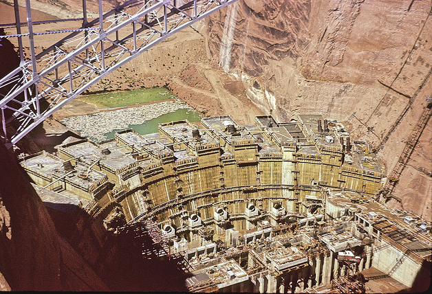
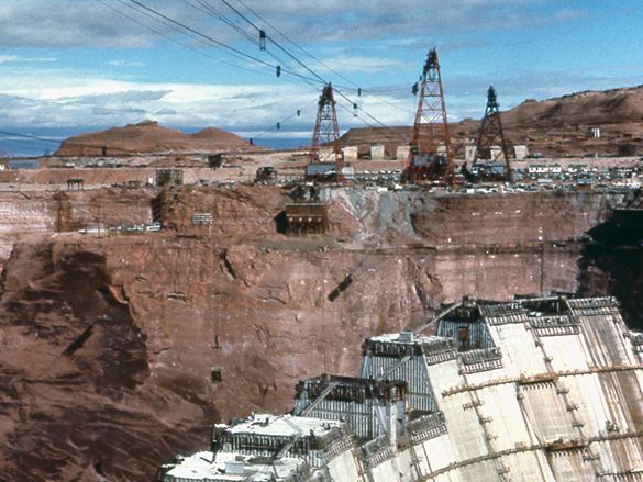
It All Started With A Loud Blast! In 1956, President Dwight Eisenhower had pushed a button in our Nation’s capital that set off the first charge for the dam site at Glen Canyon’s narrow southwest gateway. Here's just one of the gigantic bore holes gouged in Glen Canyon's walls:
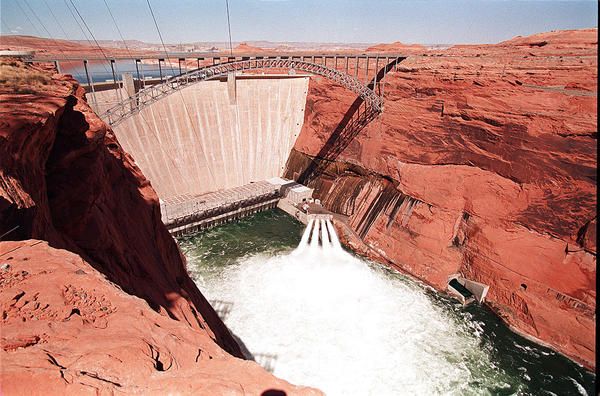
This sector is where the engineers decided a skyscraper-scale dam would rise from the canyon’s shadowy and sandy depths. The following year the steel-arch, single-span Glen Canyon Bridge would begin its construction, thus facilitating transportation of materials for the dam project. At the time, and measuring 1,271-feet long and 700 feet above the chasm, it was the highest arch bridge in the world. While workers fabricated its admittedly striking structure, a coffer dam was built and work on the mammoth barricade more or less proceeded on schedule. Protestors could only watch from the distance, though still waiting and hoping a reprieve granted by the courts came through. It never did.
By 1963, the right diversion tunnel was closed. That occasion was on January 21 and officially marks the genesis of Lake Powell. Afterward, the Colorado River would have to rise an additional thirty-four feet to reach the temporary diversion tunnel on the left wall. The dam was also completed in that same year, with the second diversion tunnel sealed on March 13. Then on April 18, the stymied river suddenly broke free of its earthen coffer dam. However, the return to the Colorado’s freedom was quickly revoked when its flooding rampage was turned back. The wrangler-engineers said NO to the stallion river and YES to the lake it was impelled to create. Effectively, the river's intravenous diversion tunnels life support were cut off. Creating the new water-world environs slated for Glen Canyon’s interior was underway again.
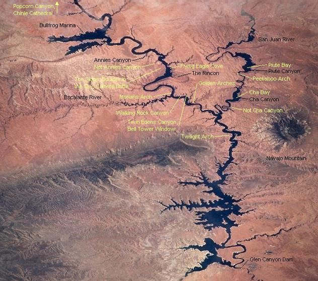
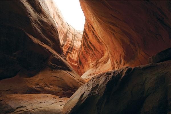
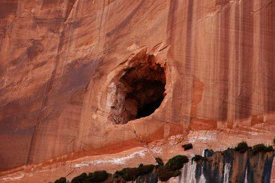
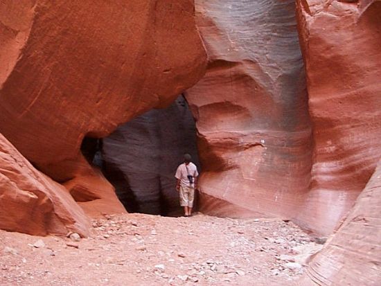
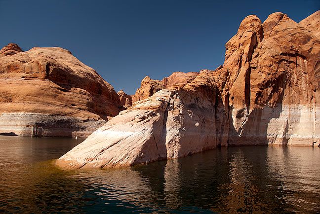
Up went the wall––that cement warden––and that muddy river backed up and rose above its channel, fanning out left and right into the canyon's interior. The first of the Glen's human and natural assets to go were lower archeological sites and haunts closer to the channel. In time, most of the ruins and all of the chamber haunts were interred. One by one these human occupied and idyllic places went under: Navajo Canyon, West Canyon Creek, Dungeon Canyon, Grotto Canyon, Wetherill Canyon, Little Arch Canyon, Cathedral Canyon (not to be confused with Cathedral in the Desert which also ultimately suffered the same fate), Cascade Canyon, and a litany of many, many others. Considering how erosion had honed the Glen's features in a spectacular and singular fashion, taking millions of years to sculpt her interior, what happened here took place in a relative blink of a dam engineer's eye! For instance, such places like this side slot canyon:
And so, the wall went up, the lake went up (it grew deeper) and the Colorado gradually dissipated its muddy appearance. In time, it meekly flowed hundreds of feet below its jailer, headed downstream toward Lees Ferry a former shadow of itself, both in strength and hue. Mostly free of its sediment it was clear and green and amendable to a proliferation of algae.
Glen Canyon’s planned fate and revamped mien––as a dam and water storage facility––was the proverbial Amen, the mass has ended, folks, and let's celebrate the net results of the epic undertaking. The masses bowed their heads, then applauded. Most never even knew the former environs. As expected, the transfiguration by a dam to a basin storage and hydroelectric facility rattled and addled supporters who decried Glen Canyon’s deluge. The protestors also faced a gauntlet and a reinvigorated and defiant commissioner. Again. It seemed he and the agency were utterly invincible; also manifestly sneaky.
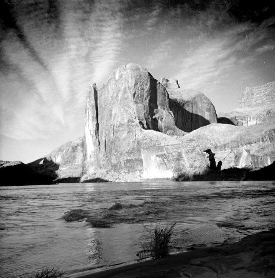
Meaning, if you were around during this incipient dam-building phase, imagine watching this site's construction from the sidelines and powerless to do anything about it:
As I said. . .the mass (for the Glen) was ended, but there was no gong and incense in this profane affair (it was to them, profane). Then a new mass was about to begin. This time vehement protests waged against the BOR's wanton ways (i.e., business as usual stance). Dominy, however, was his usual presumptuous self, for he dismissed his enraged opponents that dared to desecrate his next altar downstream by challenging his authority. Since the Glen Canyon's Dam contract had been awarded to the Merritt-Chapman & Scott Corporation for an outrageously low bid of $107,955.552, the commissioner's next idea for dam building would also be comparatively low. But he didn't need a bunch of tree-hugger types buzzing angrily around his head, like hornets with legs. What he needed to placate was Congress, by seeking approval and funds for his next ambitious plans and projects, and of course, the lower the bid, the better chances for approval.
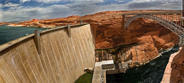
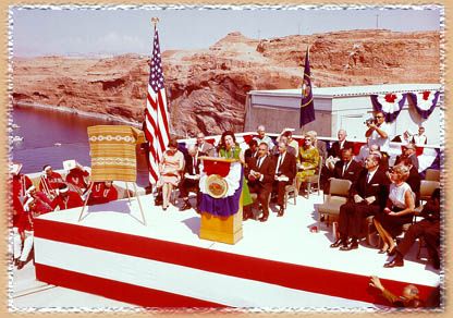
(FYI: Concrete placement for the Glen Canyon Dam began on June 16, 1960. Meanwhile, Senator Carl Hayden, along with his cohort sponsor in Congress, Arizona’s Barry Goldwater, were praised for their pivotal roles in having secured Congressional funding and support for the project, with Senator Hayden acting as the more forceful of the two senators. With its miles of internal pipes cooled by ice water to expedite the hardening of the cement, from start to finish the structure took some ten years to build. The sweeping and latest barricade impeding the Colorado River was boasted as another BOR masterpiece and would be dedicated (in 1966) by Lady Byrd Johnson.
Likely, Dominy figured the two senators, along with other key House of Representative iconic figures (i.e., Colorado's Wayne Aspinall and Arizona's Mo Udall) would go along with his latest scheme. If, as the saying goes, politics makes for strange bedfellows, toss in an aggressive dam-builder and canyon-slaver, like Dominy, and standby for an all-out orgy. From Abbey's POV, he would likely add to this thought, "The screwing is one thing, but it's worse without the lubricant!")
Incidentally, the Bureau of Reclamation is traditionally a part of the Interior Department, of which the National Park Service (NPS) is a subsidiary branch. The commissioner is also directly responsible to the Interior Secretary and the President of the United States, at least in theory. He therefore obeys the wishes of whomever is in office at the time. This policy is also a classic perfect world scenario. In actuality, the BOR essentially doesn’t follow a chain-of-command mode and the agency is really a step-child of Congress. Both Congress and the BOR may be under the auspices of the President, though both may be unruly children, and therefore whomever occupies the chair in the Oval Office can’t discipline or mold the child the way he would like. Behold the essence of one Floyd Dominy's methodology and admitted lack of restraint given his penchant for always doing things his way!
Here more info about the dam is presented, both for reasons of an historical account, and because it was prototypical of more like it to come.
Das Ding An Sich! By design, the edifice that impeded the Colorado River for the first time at its upper basin sector was classified as a gravity-arch dam. It was the latest concept for large dams especially built for bottling Western rivers. Slightly scaled down from its original planned height (because the added height would have also flooded Rainbow Bridge National Monument which Brower did at least win that battle), the dam rose 710 feet in structural height (from the bedrock). With a hydraulic height of 587 feet above the Colorado River, the length of the crest was 1,560 feet, measuring 25 feet thick at its crest and 300 feet at the base. Impressive because of its virile design and dimensions, it was one of the largest dams in the world (though not the highest). It took 4,901,000 cubic yards of concrete aggregate and rebar to construct, assembled one big block at a time. When finished, forty-eight enormous cubes formed a wide, thick and concave wall set against the reddish-brown and bronze canyon, whose sheer and dark-stained walls anchored and stabilized the foundation. The dam and its hydroelectric capacity was mainly envisioned as a storage-basin project consigned to the Colorado River Storage Pack’s (hereafter, CRSP) fleet of similar facilities. Consequently, it was an auxiliary hydroelectric generating facility created for this primary purpose, although with secondary advantages. Namely, a recreational value.
(FYI: Although constructing this dam did not take the scores of lives that were lost in its near-sibling, and larger, dam downstream, the Hoover, there were many problems early on in this venture building the structure. According to one story, and allegedly posed by an elderly Diné (Navajo) sheepherder), the canyon that was about to be flooded was protected by chį́įdii (ghosts). Allegedly, these spirits would do whatever it took to protect their hallowed ground (specifically, where spirits were interred for centuries). Whether the story is true or based on tribal superstition, it would seem early on how the project was jinxed. For instance, transporting workers and equipment to the bottom of the ravine was hairy in all respects. Thus workers were prone to accidents. Transport (initially) was was also accomplished by a barge operating from Wahweap Creek, its gravel deposits upstream from the dam site. When the barge had capsized one day, and spilling tons of machinery into the river, the danger got the full attention of the workers and engineers. The geology of the canyon was also problematical for workers. Sandstone usually is. For instance, during the initial excavation phase the facade of the canyon walls frequently broke apart (what geologists call “slabbing”) and collapsed into the diversion tunnels. Huge metal bolts had to be drilled into the canyon walls just to secure the foundation at those sectors. Then on August 5, 1958, some 5,200 cubic yards of rock suddenly crashed down onto the upper portal of the left diversion tunnel. Not good for morale or project accomplishment. Obviously. Setbacks like this, along with workers dissatisfied with a new contract that lowered their wage scale, delayed the process. Construction ultimately claimed eighteen worker’s lives and an untold number were injured. Still, compared to the higher loss of life and injuries at the Hoover Dam site (unofficially, well over one hundred), it was an acceptable loss from the BOR’s perspective. As for the haunting of Glen Canyon’s previous enduring inhabitants, who really knows about such things?) But there are signs, some cryptic, some clear, and maybe some are dire warnings. . .)
Moving the clockworks forward, specifically into the 1980s, the dam had long since solidified, the basin-bathtub filled to its predicted brim, and the unnatural matchup of its water submerged an average 525 feet of the Glen’s interior (though deeper water closer to the dam). The odd phrasing (unnatural) describes the retrofit and implies nature had created this desert-canyon topography for an impressive inventory of chasms originally cut by two principle rivers (the Colorado and Green) and honed by the elements of erosion. But it’s mankind that tends to tinker with nature’s creations, in this case modifying a primordial template for the sake of basin storage. A done deal, remember? Depending on which side of the dam-fence issue one takes, also depends on acceptance or rejection of bureaucratic agencies mandated to accomplish such promethium projects. In this case, obliging earlier endorsements for basin storage allocated by the CRSPand predicated on the BOR’s role designed to oversee development of the upper Colorado River basin. As you will recall from the previous diary, these projects include flood control, water storage and hydroelectric power for key participating states along the upper portion of the Colorado River, including its major tributaries. Since the time this project (act) was approved (1956) the bureau had effectively augmented its power and prowess by advancing other water management projects throughout the Colorado River’s basin. Thus a plethora of dam sites indicates a nominal policy administered by the BOR. Participating states involved with the CRSP are: Arizona, Utah, New Mexico, Colorado and Wyoming.
(FYI: Before the 1950s the index of potential BOR project sites included Colorado’s Gunnison River and Wyoming’s, and Utah’s Green River’s ensemble of the Flaming Gorge Reservoir, Horseshoe, Kingfisher, and Red canyons––all eventually flooded by large deep water basins. In fact, all the rivers, from the San Juan to the Delores (in Colorado) and the Salt and Gila (in southwest Arizona) were scheduled for damming. Likewise, California had witnessed a glut of dams built since the 1920s that lasted well into the 1980s.)
Actually, the concept of the CRSP was previously conceived by the BOR in the 1940s but not earmarked for funding until the early 1950s. In 1956, Congress passed the CRSP’s hurdles with this key proviso: no dam or reservoir would be constructed in any national park or monument. Behold one of the reasons Brower was able to defeat the BOR at Echo Park. He and fellow dissenters may have figured Glen Canyon was also safe because of the 160-acre Rainbow Bridge Monument and the law that protected its turf (passed in 1910). Well, we all know how and why we spell the word assume.
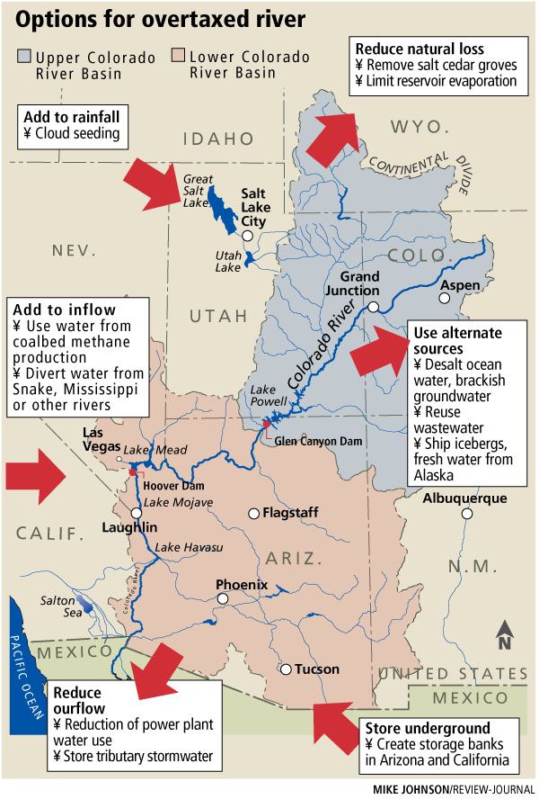
(FYI: As for the history and utility of the Colorado River Compact, it was initially drafted in 1922 among seven Western states divided into Upper and Lower Basin water resource management jurisdictions. The pact governed the apportionment of water rights to the Colorado River and was signed by state representatives at a meeting held at Bishop’s Lodge, near Santa Fe, New Mexico. These seven states (Colorado, New Mexico, Arizona, Nevada, California, Utah and Wyoming) had previously formed the League of the Southwest (in 1917) intended to promote development along the Colorado River and its vast watershed (including the sister drainage, the Green River). Four years later Congress authorized delegates from the seven states to enter into a compact agreement intended for allocating the river’s liquid assets. Never mind the fact the State of Colorado already had a sly idea of claiming more assets, because in Colorado this prima donna of Western drainage flows was locally known as the Grand River (entering the canyon country just above the confluence with the Green River). Since the Colorado (Grand) River originated in the state politicians also thought or assumed the state government should control most of its resource (which at the time it was called the Grand River). As it turns out, Colorado, the state, was overruled on its attempted and crafty legerdemain. Thus the name of the river was thereafter standardized along its entire length.
Incidentally, the apportionment agreement, despite the fact it was signed by all seven states, was dubbed controversial almost from the start. Arizona, for example, was dissatisfied with the lower basin allotment it was granted and therefore refused to ratify the agreement until 1944. Then again, litigation over water rights is as common to the Western territory as land grabbing was in the mid-Nineteenth Century. The continued fallout of this argumentative matter was also bitterly contested by Southwest Indian Nations and Mexico. Thus far, California and Arizona are the biggest Cadillacs fighting at the trough––a slight euphemism for water hogs, which Marc Reisner might have sanctioned using the phrase.)

The historical account that began at Bishop’s Lodge later added to serious (read inflamed) disputations posed by Brower. Mainly, his intention (of course, implying the Sierra Club's backing) was to show how and why the federal government, by going ahead with the Glen Canyon Dam project, was contributing to older problems that really had never been resolved. For instance, the allocation of water rights for each state that were initially based on extremely wet years, while the actual calculations should have been much lower. In short, someone didn’t do his homework right. Brower, however, intended to show the bureau’s math, that is, given its zealous engineering plans that turned out to be erroneous. Thus Brower proved his point. Not bad for a man who never earned a university degree!
Let’s think about this point for a bit. Notably, how quickly the BOR’s exuberance had exchanged places with hubris, and how the basin was always suspect in the eyes of conservationists and supported by a phalanx of key scientists. From hydrologists to climatologists, even geologists who knew sedimentary rocks from sedentary bureaucrats working in Washington, D.C., each had sensed the insatiable drive to control the Colorado River's assets. In short, its limited resource was getting out of hand. These scientists also cited Lake Mead’s previous woes with aggradation, particularly how the problem was not given enough credence. Hence, either key players by creating Lake Powell were misinformed or utterly naive about what sandstone terrain typically means to rivers and streams coursing through such predominant lithology. (On this note, should we give the BOR the proverbial benefit of the doubt they really didn't expect such a huge amount of sediment inflow into the basin, and so quickly? Nah, let's not. Even a child knows what happens if you put a chunk of sandstone in a bucket of water and how relatively quickly and easily its clastic particles come apart. Hence, from sandstone comes sand. The more sandstone there is, the more sand is transported in nature's handy conveyor belts slicing through this country. . .rivers and streams.)
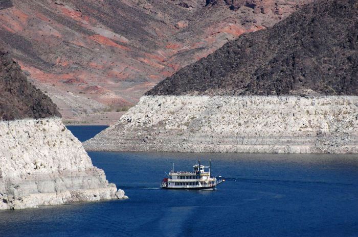
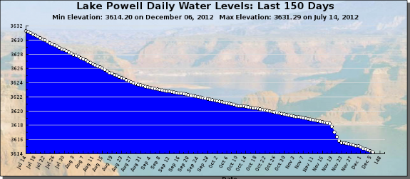
While the bureau was eager to relieve Lake Mead’s problem of aggradation, which effectively began a mere twenty or so years after its basin had stretched out 120-miles behind the dam, by the early 1960s it was obvious a new and similar problem was at stake. Thus another basin farther upstream would be necessary and therefore curb the greater inflow of sediment filtering into Lake Mead’s basin just below the Grand Canyon. Here's another child's question to pose: Do you think Lake Mead engineers and hydrologists are concerned about aggradation these days. . .or drastic lower water levels? From this fairly recent picture it seems they should be concerned:
In those incipient twin basin years laid out at either end of the Grad Canyon, Lake Powell’s bigger trough did just that––save its downstream neighbor. All told, Lake Powell was sort of like a colossal dragnet trapping sediment inflow (starting at the lake’s upper sector), while giving Lake Mead ample time to purge its own constipation problem. Consequently, the 1980s typify a banner decade of success for Lake Powell’s utility––its buffer mode in the proverbial knick of time. However, most of the public at the time knew only recreational advantages to enjoy, which spawned another great inflow never before seen in this region: mega tourism. Then again, Lake Powell was the latest project in the Upper Colorado Basin country and its appeal to the masses was a given. Essentially, creating this gigantic lake with an average one-mile width was an ersatz plan of action considering its own fate of accumulated silt fallout that started showing up in the 1990s.
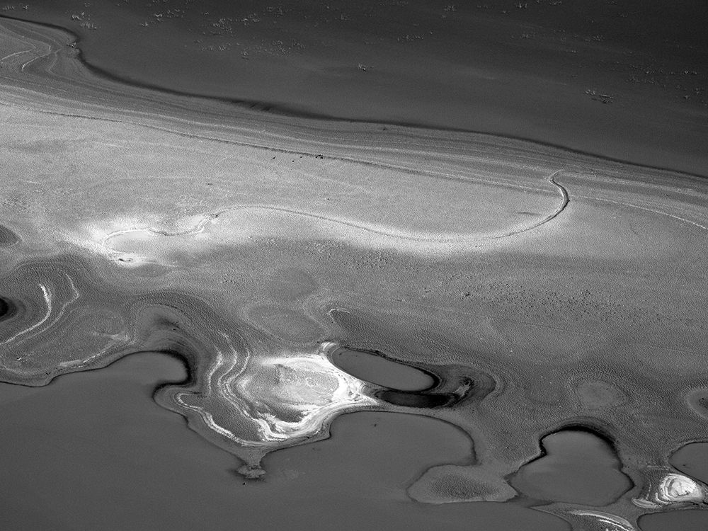
Mentioning this point brings to mind evidence for Lake Powell's accumulating muck ever since. For instance, sonar mapping has tracked the fallout over the years, at least when such tests are conducted. Topographical mapping of the basin floor has also confirmed big blobs of gummy and congealed residue have since smeared sectors of the lake, starting somewhere below the known alluvial fans where the rivers funnel into the basin. Moreover, it’s not just these greater deposits that denote excessive dumping-off points. Gravity is indeed lending a hand moving this stuff further into the lake. Ergo, an anomalous blob or blobs crawls somewhere below the surface. Out of sight, out of mind, right? Well, consider what muck looks like when lake levels seriously drops. . .
On this muddy note, a suggestion of using detailed sonar maps for select areas before the dams went in can be correlated to contemporary basin-floor mapping. With all the sophisticated electronics available today, comparison studies could better address and reveal aspects about a whodunit source which some hydrologists know (i.e., given current accumulative amounts). The findings of these twin-era maps, along with water samples and other relevant tests, could then adjust the ticking clock of Lake Powell’s basin. In short, a ready and reliable means to define just how long its utility can be counted on.
(FYI: Assuming that sediment continues to pour into the basin at an alarming rate calculated from sonar surveys conducted in the 1980s (though later reports after this benchmark are still not available as of this diary's posting), what positive or grim forecasts is really at stake? As you can expect, the answer is rather mitigated.
The positive account holds this view: To fill Lake Powell’s 27 million acre-feet (its projected capacity at full pool) it would take about 700 years (where an acre-foot equals about 326,000 gallons). Briefly touched upon in the previous diary, this liberal timespan is considered by some scientists nothing less than a gross overestimate. Indeed, many scientists predict within two decades, perhaps three at the most, the escalated demand for Colorado River water, along with a continued falling supply, will significantly drop the surface of the reservoir to its lowest level, known as dead pool. Because the lowest exit from the dam (at the river outlet works) is 237 feet above the original riverbed, at the level of dead pool Lake Powell will still hold some million acre-feet of water, one-thirteenth of its capacity. In short, to fill this still hugely long lake (i.e., the 2 million acre-feet figure) with sediment won’t take 700 or so years. Instead, 50 to 60 years is a more realistic figure. There is also one other problem dam engineers and scientists are keenly aware of, namely basins are designed to hold water, not silt. Duh! Consider this mass-like putty substance in the guise of typical mud, only a grayish, sickly color. Wet mud weighs roughly twice as much as an equal volume of water. It’s also estimated Lake Powell has room for about 70 billion tons of sediment (a view held by lake advocates). Still, the pivotal question to ask is the same one intimated earlier: How much aggradation has already effected the lake and how much more can it hold until its basin is essentially gorged and the dam and dam works threatened?
Let me add the obvious: Whenever estimates of aggradation and diminished lifespan (of the lake) comes up, thus utter disagreement by opposing sides commences, each faction will suggest two different remedies to heal the patient of its constipation problem. Complicating matters is how one side more than the other appears to favor science and research in prescribing the antidote, while the other tends to distrust or downplay scientific modus operandi and its usual summary reports. In short, when conferences concerning the patient are convened one can expect to hear almost anything in the way of suggestions.) Given this science. . .
So then, where will these folks go next, that is, should the worst really happen?

There is that problem (of aggravation. . .ongoing) and there is also the complication of manmade pollutants, starting with ubiquitous streaks of iridescent swirls of gasoline on the surface, and caused by a variety of large and small watercraft. Factor in human waste (spawning e-Coli) and assorted non-biodegradable garbage; also adverse natural mineral contaminants, such as arsenic, mercury, selenium (to mention some dangerous trace elements), even pesticides that are trapped in the basin. Such fairly nominal bulletins are regularly submitted by scientists and presented to the NPS management. Most of these matter of fact reports and graphs can be viewed on the web. While scientific jargon can sometimes be seemingly inscrutable, the recorded numbers and findings given test results are simple enough for most people to understand.
(FYI: According to a sediment chemistry survey conducted by the U.S.G.S (Open-File Report 2005-1178 and contributed by a variety of researchers), the report focused on the Colorado River delta of Lake Powell and was prepared in cooperation with the NPS and Glen Canyon National Recreation Area. The significance of the abstract showed how sediment delta deposits provide a repository for the potential accumulation of various natural and human-introduced chemicals. In particular, the Colorado River delta of Lake Powell near Hite extends for many miles into Lake Powell and is thickest near the mouth of the Dirty Devil River. Thus don't try and launch here unless you're prepared to hand-carry your vessel:

Other significant deltas in Lake Powell occur at the mouths of the San Juan and Escalante rivers. Sediment samples collected from the Colorado River delta during July 2001 were analyzed for concentrations of major ions; trace elements; organic compounds, including low-level organochlorine pesticides, polychlorinated biphenyls, and polycyclic aromatic hydrocarbons; and radionuclides. (2001‘s results are still unbelievably the most current and reliable figures released, even though in successive years more intense testing has taken place, only it seems these reports are not readily available to the public. So far, not available.) Three cores and six sediment samples from the sediment-water interface were collected near Hite Marina in southeastern Utah where the delta is thickest. No trends were discernible between major-ion concentrations in different cores. Concentrations of several trace elements were correlative with sediment color and texture. Elements that are considered to be environmental contaminants, such as arsenic, uranium, selenium, and mercury, were detected in core samples. Some elements increased in concentration with core depth.
Thus this scientific jargon comes down to the fact organochlorine pesticides and polychlorinated biphenyls were not detected in composited sections of the cores above the BOR’s detection limit except for p,p’-DDE, which is short for the much longer dichlorodiphenyldichloroethylene––and for me I just call it the “big ass D word.” A total of nineteen parent polycyclic aromatic hydrocarbons and multiple alkyl-polycyclic aromatic hydrocarbons were detected in core samples. All core samples contained concentrations of gross alpha and gross beta radionuclides; concentrations in composited samples ranged from 11 to 17 picocuries per gram. For the layman weighing in on such news, it comes down to the point most people know. . .or should know. . .clear water is not analogous to safe water. This basin's variety of pollutants is also not getting any healthier. And if this advice is not making sense, surely this admonition will: DON'T DRINK THE WATER, DUDE!)
As for those millions of people supporting the lake and its presumed wholesome status, yes it’s true Lake Powell has been an undeniable economic boost to the region. Who can say otherwise? BUT. . .it is equally true the basin’s continuing environmental woes are just that––continuing woes. Downstream, especially in the riparian corridor of the Grand Canyon, the Department of the Interior (notably, the NPS's arm of its jurisdiction), has made specific environmental concessions known by dealing with critical changes caused by the cold, clear water flowing down there in the deep time corridor. So there is that aspect of what's happening below the dam and because of the dam!
(FYI: Other than aforementioned attempts to restore beach erosion, and maybe clear out some of the pesky tami (tamarisk) growth, the buildup of algae is another environmental problem that has always concerned biologists. Ample sunlight abets its growth and colonization wherever clean water flows. Algae is also a large and diverse group of simple, and typically, autotrophic organisms ranging from unicellular to multicellular forms. Previously mentioned, and here elaborated, water, once it exits the Glen Canyon dam, is a fairly translucent and greenish tincture because of this omnipresent life form––algae. What flows downstream is therefore not the right color, chemistry or ideal temperature native fish and other biotic communities require. Neither can some of these life forms adapt to the changes of temperature and chemistry. Thus they either died off or have escaped to water side streams, including the Little Colorado River, at mile-60 below Lees Ferry.)
The common analogy of cold dam water due to the release from the Glen Canyon Dam is like serving ice coffee to someone who prefers his or her beverage much warmer. In addition to this complication for dam-fed rivers, the basins feeding downstream riverine corridors also have their share of problems (and not just aggradation). For instance, excessive growth of plankton (drifting organisms) may limit the recreational use, as well as the commercial utility of its fresh water. Notably, deep-water basins develop pronounced thermal barriers (see below) and anoxic zones (water without oxygen) in the summer turnover or else mix during the fall season. The spatial distribution of fish within a lake is equally sometimes adversely affected by thermal stratification. In some cases, stratification may indirectly cause large die-offs of the lake’s recreational stock. One commonly used tool to reduce the severity of lake management problems is to eliminate or lesson thermal stratification through a process called aeration (circulation of air mixed with or dissolved in a liquid substance). Many types of aeration equipment have been used to thermally destratify lakes. Aeration has met with some success, although it has rarely proved to be a lasting panacea.
(FYI: This is probably too much information for some people, however it explains why dam water is so damn cold and harmful to downstream ecology. For instance, thermal barriers (also known as thermoclines), denote thermal stratification layers that are a direct response to the unique relationship of water density and temperature. Scientific reports on the web tell us how the maximum density of water occurs at 39º F. As water cools below this temperature, it also becomes lighter. In Lake Powell’s deep-water basin, and others like it, lake stratification amounts to the separation of three distinct layers: epilimnion (the surface), metalimnion or thermocline (middle layer that may change depth throughout the day) and hypolimnion (bottom layer). What’s important to grasp about thermal stratification is a change in the temperature at these various depths. The change is also due to a corresponding change in water density interacting with temperature. Because cold water is denser than warm water, the epilimnion layer generally consists of water that is not as dense as the water in the lowest layer (hypolimnion). It should also be noted how the oddity of Lake Powell’s distinction between the metalimnion and hypolimnion is typically unclear. That’s because continual voluminous water exchange often blurs the boundaries between thermal layers in some reservoirs especially this lake. The water exchange also directly relates to a continuous withdrawal of large amounts of water from the bottom of the lower zone which is consistently cold (about 44.6 F). Large additions of water at the upper end, where it is much warmer near the surface, exceeds 77º F, but only during the summer months.)
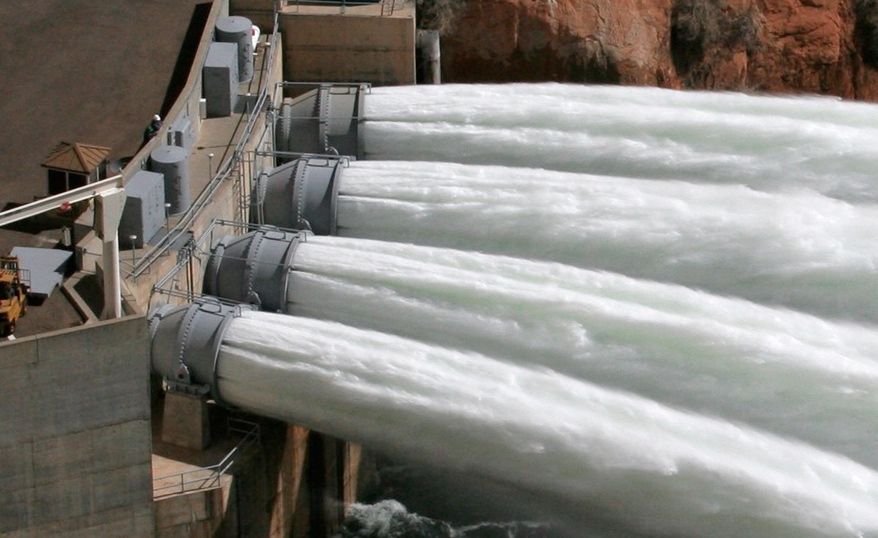
Next, let’s consider how the BOR, when preaching its practiced doctrine to the masses, had promised to curb springtime flooding by hobbling the Colorado with cement and rebar. As the 20th Century’s Sir Karl Raimund Popper, a renowned philosopher of science reminds us, anytime a problem is solved, call it P(1), another problem issues (P2). Thus those former and historic great floods racing and roaring through the Grand Canyon surely were halted when the dam closed its mouth (except during the monsoon season). As a consequence, most of the river's high-yield sediment laden water was thoroughly cleansed as though baptized by the dam. What little sediment flows in this afterthought of a river since the 1960s is relatively miniscule. Ah, but then someone thought of a way to try and recreate the former monster flows. Now called artificial deluges, though officially dubbed HFE’s, meaning high-flow experimental releases, the high-volume water scoured the canyon corridor with intense flood-level releases, while transporting prized sediment along for the ride. The HFE experimental floods started over twenty years ago, while key tests have been performed in 1996, 2004, 2008, and more recently in 2012. Spewing out hundreds of feet from massive jet tubes at the near base of the dam, each powerful cubic feet per second (c.f.s.) release is like watching waterfalls flowing horizontally outward. Shooting out hundreds of feet, the added grit in the rushing and roiled water is said to mimic historic floods, and that claim is apparently one of those ‘gud enuf’ scenarios embraced by those who think the deluges are noteworthy.
And for a time, the HFE projects were successful by restoring former beachheads that had long since turned into rocky outcroppings. Then again, test results were ephemeral. Orchestrated by the Glen Canyon Dam Adaptive Management Program these floods are nevertheless carried out in two phases: the first allows more testing to measure the buildup of beaches and backwater habitats that have been lost or ruined due to the Colorado’s highly modulated flow, while the second entails surges and treatments designed to reduce exotic predatory fish that feed on and compete with native species. (It would seem violence is everywhere, yet by Nature's hand it is simply a normal function of the so-called trophic cycle.) In 2012, these simulated floods will continue at select interval (releases), and more studies based on previous studies will compile still more data for future studies. (In short, researchers on these projects like the studies as much as they enjoy ample play time on the river!) It seems likely what engineers and hydrologists are trying to work out is some kind of a reliable rubric. For instance, how long these artificial deluges should last and how much c.f.s. is necessary. (An average 41,000 c.f.s. is considered a typical HFE flow and measurement.) Some scientists think less c.f.s. may work better, though allow for longer durations of flooding. Others think the floods should be released more often, while maintaining a higher c.f.s flow. (Meanwhile, some folks think a bigger flood downstream is better!)
There is that continuum of science and studies and there is human nature applicable to those who plainly aren’t interested in such scientific results. Namely, and to the chagrin of anglers, their complaints center on lousy fishing below the dam during the high flow releases. For some Page council and business members, their grouse is also akin to dam engineers giving away too much of a darn good thing. Thus diminishing the volume of the lake whenever the HFE’s are authorized. Meanwhile, the Grand Canyon Trust, among other nonprofit organizations heavily engaged in this ongoing matter, argue the experiments amounts to a huge waste of water, time and money. Do you think?
(FYI: Artificial floods follow a science-based Protocol for High-Flow Experimental Releases from the Glen Canyon Dam, which is a component of the Department of Interior’s compliance with the Grand Canyon Projection Act of 1992. This act further mandates the dam be operated in a manner that protects and mitigates adverse impacts, while improving the values for which Grand Canyon National Park and the Glen Canyon National Recreation Area were established. In short, and thus far, negating charges levied by the Grand Canyon Trust or similar other organizations.)
Returning once more to the previous diary, recall how a portion of its information posited a heightened concern of Page business owners and residents possibly some day forfeiting their community’s economic driving force, whose dire projected forecast entails losing Lake Powell as a standard feature out their backdoor. Thus a worrisome scenario where the dam is dismantled and the basin drained. Consequently, Glen Canyon's lower sector will be utterly bleached and quite a contrast to her upper profile. In short, it ain’t gonna be a pretty backdrop, folks. (Think of a farmer’s tan, where the arms and legs are exposed while the rest of the body is clothed.) That’s the kind of two-toned appearance Glen Canyon will reveal until the lower profile regains its former color. That staining by ample sunlight and patina (a/k/a/ "desert varnish") created by oxidation or other chemical processes might take as long as forty to fifty years. Maybe a tad longer.
Again to mention it, these particular requisite concerns for Page’s citizens are valid. The same holds true for tourism’s loss of an admitted booming vacationer’s paradise that easily controls the lion’s share of aquatic-related tourism throughout the Southwest, that is, primarily based on a variety of lake activities. Lake Mead, Mojave and Havasu also claim a similar bonanza catering to such means of generating revenue. However, Lake Powell’s consistent millions of annual visitors is far greater than any other lake-basin attraction. It follows how advocating for the dam and lake is based on a high approval rating by tourists coming from all over the world. So be it!
On the flip side, however, it really isn't the case there are mean-spirited people who are out to deprive Page and the tourism industry of billions of dollars of potential revenue (i.e., ogre scientist types, NPS overseers prone to bureaucratic stall tactics, inflamed and impatient environmentalists, continued curses from Abbey's still secret place of internment, among others of his cynical persuasion). Once objective reality is grasped, if such a thing is even possible at this point, the scientific rationale attempting to ameliorate an ongoing, and heavily, disputed situation essentially comes down to posting notice how Lake Powell, unless its momentous environmental problems are fixed, and fixed for good, will one day be declared defunct and its dam works incapacitated. Hence, Drain-O (by dismantling) may be better for relieving the lake’s excessive buildup of accumulated silt and other contaminated ailments. Whether such a drastic measure entails a no-refill prescription (for the lake) is not known, at least there doesn’t appear to be too much discussion about this irrevocable outcome. Still, known problems about Lake Powell’s progressive aggradation, its contamination by human and nature-caused pollutants, and that trump card of nature, drought, is where arguments should be focused––not egos, wagging tongues and pointed fingers that perpetuates diatribes, disagreements and discriminatory POV’s. At this point of the discussions, it's also a safe bet to say how all the so-called lake rescue scenarios, some of them quite outlandish, are not green light agendas. Hence, there are lights burning on front lines that are a cautionary yellow or a dead-red. And so discussions continue, seemingly ad infinitum.
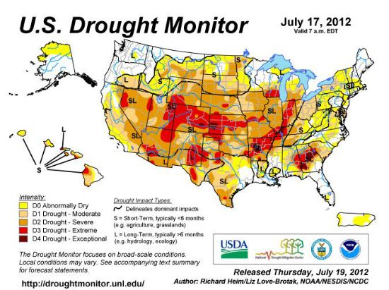
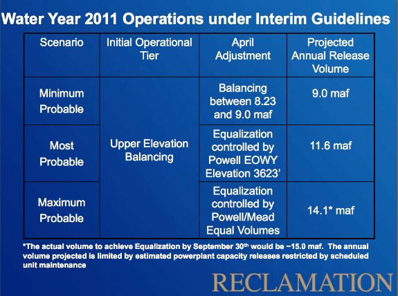
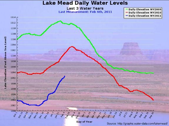
According to a fairly contemporary article posted on the Internet (February 5, 2008) by the BOR’s Resource Manger, Rick Clayton, he based his seeming auspicious conclusions on upper Colorado River basin hydrology, citing precipitation was 160 percent of average in January 2008. This was the second month in a row where basin precipitation was well above normal, and making up for a very dry November 2007. Basin wide snowpack was only 35 percent of average on November 29, 2007, but increased steadily during December 2007 and January 2008 to 132 percent of average on February 4, 2008. The climate outlook over the next three months was for near normal precipitation and above normal temperatures. Inflow to Lake Powell was currently then at 7,400 c.f.s. (February 4, 2008). Total unregulated inflow to Lake Powell so far in the water year 2008 (October through January) was 82 percent of average with January measured at 83 percent of average. Forecasted April through July unregulated inflow to Lake Powell in 2008 was 9.5 million-acre-feet (maf), 120 percent of average (February final forecast). This inflow projection could shift depending upon climate patterns realized during the remainder of the winter and into the spring. Typically by February 1st, the snow accumulation season is about 60 percent complete. (This next graph is from 2012 and goes to the middle of July):
(FYI: Looking at the analysis with more scrutiny, on February 4, 2008 the elevation of Lake Powell was 3,590.5 feet, denoting 109.5 feet from full pool elevation (3,700 feet). Reservoir storage was 10.87 maf, or 45 percent of capacity (though in recent years that figure has lowered). The water surface elevation of Lake Powell was near its seasonal low. In April, anticipated snow melt runoff was predicted to cause the water surface elevation to increase. Under another inflow forecast, Lake Powell would reach a peak elevation of about 3639 feet in July 2008. Compare this figure to a peak elevation for Lake Powell in 2007 which was 3,611.7 feet.)
Drought! Even those advocating the lake and dam cannot deny a long dry spell's tenacious grip and temperament affecting much of the Southwest (and West). Regarding the Upper Colorado River basin figures, and regardless of Clayton's or anyone's sanguine basin level reports, Lake Powell is still experiencing a protracted multi-year drought. Since 1999, inflow to its basin has been below average in every year except one. In the summer of 1999, Lake Powell was essentially full with reservoir storage at 23.5 maf, or 97 percent of capacity. Inflow to Lake Powell in 1999 was 109 percent of average. The manifestation of drought conditions in the Upper Colorado River Basin officially began in the fall months of that seeming promising year. A five-year period of extreme drought has thus occurred in water years 2000, 2001, 2002, 2003, and 2004 with unregulated inflow to Lake Powell only 62, 59, 25, 51, and 49 percent of average, respectively. Lake Powell storage also decreased through this period, with reservoir volume reaching a low of 8.0 maf (33 percent of capacity) on April 8, 2005. Drought conditions eased in water year 2005 in the Upper Colorado River Basin. Precipitation was also above average in 2005 and unregulated inflow to Lake Powell was 105 percent of average. Lake Powell increased by 2.77 maf (31 feet in elevation) during water year 2005.
According to the latest information posted on the Internet (as of this writing), so far in December 2012 the unregulated inflow volume to Lake Powell has been tracking towards a monthly volume of .357 maf, which denotes a 99 percent average. This volume is very close to what was forecasted at the beginning of January. The January most probable forecast volume was .375 maf. Currently, the elevation of Lake Powell is somewhere around 3636.98 feet above sea level (63.02 feet below full pool) and has decreased about 3 feet during the month of January. The elevation of Lake Powell will continue to decrease for the next 1-2 months as releases are projected to be greater than inflows. Later in the spring, when the snowpack begins to melt, inflows will increase above release rates and the elevation will begin to rise. Snowpack conditions above Lake Powell are 82 percent of average as of January 30, 2012.
(FYI: And this news just in. . .the BOR has received the first Water Supply forecast for 2012 and the April through July unregulated inflow to Lake Powell is projected to be 5.05 maf, which is 71 percent of average. Based on this forecast, the projected figure (50 percent likely to be exceeded) and annual release volume from Glen Canyon Dam in water year 2012 will be 9.46 maf. At this time of year however, there is a high level of uncertainty in hydrologic forecasts and the annual release volume from Glen Canyon Dam in 2012 will ultimately be based on actual hydrology rather than forecasted hydrology.)
Lest it go unsaid let us remember how one favorable year does not necessarily signal an end to a protracted drought. For example, in 2006 there was a return to drier conditions in the Colorado River Basin. Unregulated inflow to Lake Powell in water year 2006 was only 71 percent of average. Water year 2007 was another year of below average inflow with unregulated inflow into Lake Powell at 68 percent of average. Over the past eight years (2000 through 2007, inclusive), inflow to Lake Powell has been below average in all but one year (2005). Reservoir storage in Lake Powell and Lake Mead has also decreased during the past eight years. Reservoir storage in Lake Powell averaged 45 percent of capacity. Storage in Lake Mead is 50 percent of capacity.)
Are these figures leading to a suggestive testimony that is equivalent to just giving up, and therefore an inducement to not move forward with sound scientific evidence that equivocally states there really is no other choice in this overall matter (i.e., Lake Powell will end up D.O.A. in the near future)? No, not really. Most of the ideas proposed to try and save the basin thus far have received serious merit by officials overseeing discussions, including some of the more outrageous stratagems. (If nothing else, the NPS, as the responsible and chief referee overseeing this matter, its agency denotes a fair-minded government entity that must always consider options presented by the public; at least to the point the ideas presented for consideration also mesh with practicality and are economically feasible. And for those who think and claim the parkys are too flippant with their driven policies, try and imagine what some Page business owners once suggested: let them run their own lake affairs and send the round hats, packing.)
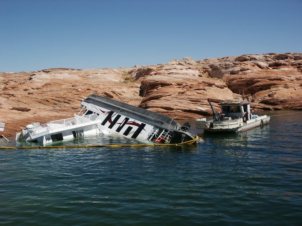
To mention it again, so far notions and theories to sustain Lake Powell, as entertained by officials, are not considered viable and timely solutions to its natural and unnatural stresses. These stresses are also compatible to a likely quick-aging process (i.e., affecting the lake’s original planned longevity). And not just the stress from heavy doses of aggradation is at stake. Diminished lake levels over time are also a concern, principally due to the previously mentioned aggravated drought conditions and excessive water use throughout the Southwest. Moreover, HFE’s meant to try and stabilize the Grand Canyon’s basement-rock corridor draws-down water from the lake. Sure, if there’s decent precipitation in the Rockies over the winter, then lake levels are higher come the spring. The other fact of life is how levels go back down again over the aging summer, fall and winter. Thus navigating large watercraft especially in the fall is a lot trickier compared to higher lake levels in the spring and early summer. Some years the number of S.O.B.B. (Save Our Big Boats) rescued from shallow water and mud is a lucrative money-making venture for towboats let’s call them. Then again, sometimes the rescue comes for another reason. . .
Oops! Well, let’s also consider another constant cause of low lake levels: the effect of solar evaporation, and more correct to call it evaptranspiration. By definition, this process amounts to the sum of evaporation and plant transpiration from the land surface to the atmosphere. The movement of water to the air from the basin, as well as the soil and atmosphere, is thus a functional phase of the water cycle. The bottom line is Lake Powell annually loses millions of acre feet of water. (As previously mentioned, one acre foot equals a football-sized stadium filled with one foot of water––325,851 gallons.) Initially, and long ago when the basin had reached its planned full pool capacity, it was an equivalent 24.3 to 27 million acre feet of water. Obviously, these figures have seriously downgraded over the years.
So, is it dialogue or Dallying? In view of the historic wrangling by both sides of this contentious issue, intelligent and realistic conservation based on discussing post 1980s facts, and not the bygone halcyon years Dominy was so ecstatic about, is recurrent. Glen Canyon Institute (http://www.glencanyon.org/) is one of many organizations monitoring whatever is going on at these round or long-table powwows, polemics, and by some accounts, stonewalling tactics to keep the debates more or less perpetual. Those who champion the lake, regardless the continuing bad report card supported by scientific data, are not easily swayed by test results. Hence, what environmental concerns? (Meaning, let’s let nature take her course.) If anything, advocates who swear there are a couple dozen (or more) reasons to maintain Lake Powell’s status quo are thoroughly entrenched with their mindsets about the lake. These include blanket statements said to issue from select and official Native American interests (decidedly “pro lake”), as well as utter disagreement against pro environmental organizations, notably the Sierra Club and SUWA (Southern Utah Wilderness Alliance). The other interesting aspect of the Friends of Lake Powell fight is conjuring up data supporting their cause, yet their evidence (such that it even goes by this designate) is a near antithesis of what a variety of scientific disciplines claims is more the case. To probe this matter any deeper entails an open mind, a good bit of sleuthing, and all the data embraced by both sides, which, again, is available on the web. However, finding the most current data and reports may take some effort (trust me on this point). Hydrology, aggradation, and sonar mapping, for instance, are tricky topics to find. Still, these reports are not akin to the X Files. We may be guessing what’s out there beyond our world, but modernity’s science and ongoing reports based on research studies is coming up with sound data. If advocates for the lake really are holding out for some other means that will be more convincing, good luck with that. Sometimes a rain dance does the trick! Maybe even prayers.
In the interim, fluctuating water levels and the telltale mineral scar, rivers flowing into the basin continuing pouring it on (aggradation) and a messy environmental status and health report is what it is. The persistence of drought, along with invasive mussel species (i.e., notably, quagga and zebra mussels) acerbates the basin’s continued problems. Also among the known organic and inorganic contaminants in Lake Basin are tons of leaking batteries (acid), high mercury levels and other trace elements, and yukky fecal coliform (E. Coli) contamination (to mention just some of the really bad stuff). These pollutants affect biota in the basin, and not only plants, avians, fish and mammals at risk, but also people. Yet the Friends of Lake Powell seem not too concerned with such evidence or they prefer being diehard optimists. To me, such a mindset is like sitting in a restaurant and assuming there are no dangerous germs to wonder or worry about. So let’s just eat and enjoy the meal while it lasts! Pass the silt and selenium, please!
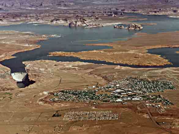
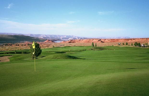
Given the steady round of discussions, and here changing Eliot Porter’s sentiments to The place that everyone knows, there remains a robust economy and exchange of commerce for the region. Let us also remember this is one of two accounts describing affairs relative to the lake and the dam. Things are likely to stay this way for sometime into the near future. Hence, Page will continue to function as a functional citadel laid out on flame-colored Manson Mesa, a secular mecca for tourism if you will, and thus the sole banker and purveyor of human services and businesses on shore. And Aramark, the National Park’s concessionaire working the lake beat, will continue its brisk seasonal (and off-season) enterprise renting watercraft of all sizes to millions of visitors, as well as managing its lodging, dining and shopping facilities. Thus a win-win scenario is established, at least from the standpoint of business as usual. Fine. Let it also be said the Glen Canyon Dam-Lake Powell affair, as a continuing topic of intrigue, will remain, well, let’s just say topical. Besides, it is either yin or yang for most people observing what’s going on from the sidelines. It follows either one is for the lake or against it. And if you love playing golf in the desert (but don't mind where the water comes from to keep the grass green). . .come to this flowering oasis and see if you can whack a ball from Page to the lake!
It seems the basis of tête-à-tête meetings among officials, business owners, tourism’s industry and tourists, even Native American tribal concerns (particularly the Navajos which leases a major generating station, at Page, to the BOR). . .each has a vested interest in the dam and lake. Each entity will also find ways and means to keep the NPS from literally pulling the plug on Dominy's big blue shining jewel. Fundamentally, there has always been a complex human element involved in this mitigated matter, where every representative at the table stands to win or lose given the final outcome of negotiations. And let’s not forget what the cadre of scientists and research have been saying all along. . .

Bringing this diary’s main points to bear, science is not a surrogate for science fiction. There are research studies and cross-studies that confirm data. For those who typically discount Lake Powell’s growing silt aggradation (among other scientific facts pertaining to environmental instability), the above facts were mentioned and based on verified evidence, and where applicable, reliable prognosis based on what has gone before, including climatic records and proven patterns based on dendrochonology (tree-ring studies); also, paleosoil samples. As for latent catastrophic dam failure caused by too much gunk in the lake (to be explained in next week’s final installment on this series), keep in mind how no dam, regardless its dimensions, shape and building materials, can endure if its Achilles heel is targeted. Namely, exceeding the structure’s hydrostatic pressure limits (i.e., by parking blobs of aggradation on the inside wall). Where the child’s game of scissors cut paper or rocks crush scissors, a deluge of water, if heavy and forceful enough, will bust through any barrier in its way.
Also mentioned from the outset, posting this diary entails a lot of information and background I think the DKos community might be interested in reading. I say this especially based on last week’s wonderful commentaries. Indeed, many readers wrote and confided how they had no idea what that other Glen Canyon story was all about. Now I'm thinking the before and after appearance makes more sense and why the transformation came about. That being said, I will continue with the diary postings (just one more) and assume I am not preaching to the proverbial choir. Rather, I am composing a new song and version for Glen Canyon’s eventual magnificat signifying a gloria in excelsis deo leitmotif, though not meant to supplicate any deity. Thus my paean to the Glen and her anticipated resuscitation by air. . .dry, breathable air for the canyon lady.

Until next week's conclusion, thank you for your patience while reading through the verbiage. As always, intelligent commentary is appreciated (as feedback).
Canyonly yours,
Rich Holtzin
Albuquerque, NM 2012
http://www.grandcanyon.org/...
