Saturn's largest moon Titan is by far the strangest place in the solar system: An unimaginably frigid world with a thick, opaque atmosphere where the clouds rain liquid natural gas, the "rocks" and mountains are composed of water-ice as hard as granite, and rivers of hydrocarbons run to organic chemical seas. It is a world with eerie similarities to the processes that shape Earth, and yet is so far outside our frame of reference in temperature and bizarre chemistry that even visiting it with robotic probes presents unique technological challenges. But most importantly, while Titan may someday become a human world, the most fascinating thing of all about the Orange Moon of Mystery is what may already live there. In Vol. 2, we explore Titan's internal structure and surface.
The progress of our adventure so far (current in bold):
1. The Sun
2. Mercury
3. Venus
4. Earth (Vol. 1)
5. Earth (Vol. 2)
6. Earth (Vol. 3)
7. Earth (Vol. 4)
8. Earth (Vol. 5)
9. Earth (Vol. 6)
10. Luna
11. Mars (Vol. 1)
12. Mars (Vol. 2)
13. Mars (Vol. 3)
14. Phobos & Deimos
15. Asteroids (Vol. 1)
16. Asteroids (Vol. 2)
17. Asteroids (Vol. 3)
18. Ceres
19. Jupiter (Vol. 1)
20. Jupiter (Vol. 2)
21. Io
22. Europa (Vol. 1)
23. Europa (Vol. 2)
24. Ganymede
25. Callisto
26. Saturn (Vol. 1)
27. Saturn (Vol. 2)
28. Saturn (Vol. 3)
29. Rings of Saturn
30. Mimas
31. Enceladus
32. Tethys
33. Dione
34. Rhea
35. Titan (Vol. 1)
36. Titan (Vol. 2)
37. Titan (Vol. 3)
38. Iapetus
39. Minor Moons of Saturn
40. Uranus
41. Miranda
42. Ariel
43. Umbriel
44. Titania
45. Oberon
46. Neptune
47. Triton
48. The Kuiper Belt & Scattered Disk
49. Comets
50. The Interstellar Neighborhood
51. Updates
52. Overview: Human Destiny Among the Worlds of Sol
53. Test Your Knowledge
Titan in near-infrared, penetrating the atmosphere to see the surface:

3. Internal Structure
Titan has an exotic and richly varied interior with five distinct layers, four of which consist overwhelmingly of H2O under varying conditions. An illustration of the current model:

At the center is a large core consisting of rock infused with water, which dominates the interior and extends roughly 3/4 of the way to the surface. Above that is a shell of high-pressure water ice in a state called Ice VI, which is one of the many different solid phases of water under different temperature and pressure conditions. The hexagonal crystals we experience as ice are just one of several possible crystalline structures that solid water can take. Comparison of "normal" water ice (Ice Ih) with Ice VI molecules:

Ice VI forms under much higher pressure than normal ice - upwards of 10,000 times higher - so as you can see, the resulting crystals are more compact. This isn't unique to Titan, by the way: Interior water ice layers on other large icy moons may also reach the same pressures, and would thus also be made of Ice VI or other crystalline phases than the Ice Ih we experience. A phase diagram shows the conditions under which each type of ice forms - note that the vertical/pressure axis is logarithmic, so each labeled notch upward is 10 times greater than the one below:

Above the Ice VI layer may be a global liquid water-ammonia (H2O and NH3) ocean, which could be liquid due some combination of radioactive decay in the core and tidal heating due to Titan's relatively eccentric orbit. Why liquid layers may occur between two frozen ice layers can be understood by looking at the phase diagram above, particularly at the apparent relationship between the Ice VI, Ice Ih, and Liquid regions. Ice VI and Ice Ih both share immediate borders with the Liquid phase, and parts of the VI region in particular can become liquid through relatively modest decreases in pressure if the temperature doesn't drastically decrease. And as we know from experience on Earth, Ih that heats above the freezing/melting point of water transitions to liquid, so that is why you can have a liquid water ocean between an Ice VI layer below and a normal ice layer above.
Like on Europa, Ganymede, and Enceladus, the presence of a liquid water ocean beneath the surface raises the possibility of subterranean (subtitanian?) life-as-we-know it (LAWKI). This is remarkable because the surface also raises the possibility of chemically exotic, non-LAWKI life that uses liquid methane in place of water, so there may theoretically be two radically unalike and unrelated biospheres coexisting on Titan. If there is any significant, regular degree of intermixing between the surface hydrocarbons and the liquid ocean, the possibilities of that would be even more mind-boggling. But I should stress there has been no specific evidence of life existing on or beneath Titan.
The next internal layer upward is normal ice infused with ammonia, and can thus be called a clathrate - a solid substance whose crystals trap other substances inside them. In this case, the hexagonal crystals of Ice Ih trap primordial NH3 molecules inside them, which formed in the very beginning of the Saturn system. Whenever geologic activity heats up parts of this layer enough to breach the surface with liquids and gases, some amount of trapped ammonia is released into the atmosphere as a warm gas where some of it is then chemically broken down by sunlight, resulting in the heavy nitrogen atmosphere we see. Ice Ih clathrate trapping an ammonium ion (NH4+) - ammonia plus a loosely-bound fourth hydrogen:

The rest of the released ammonia would refreeze to the surface because ammonia has a much higher melting point than ambient temperatures on Titan, so there could be layers of surface crust with "ammonia permafrost" denoting eras of high geologic activity. What this means is that once we're exploring the Titanian surface in depth, we can some day take ice cores like we do today in Antarctica, and studying the concentrations of ammonia in each layer of the ice may tell us Titan's geologic history.
The uppermost layer, the crust, is also mainly normal ice, but contains strong amounts of hydrocarbon solids that have built up on the surface over time. This material is a dark substance peppering the crevices between ice-rocks, forming the shores of lakes and seas, and also the exposed beds of liquid bodies that have dried up, whether just seasonally or part of long-term climatic trends. This organic/ice surface, the topmost layer, can be thought of as the "soil" of Titan.
It isn't clear how often cryovolcanism - the liquid and gas upthrusts that replenish the atmosphere with new chemicals - occurs today, or how deeply the processes that drive it originate in Titan's interior. However, several surface features have been observed that researchers strongly suspect to be ice volcanoes, and the proportions of atmospheric chemistry at low altitudes strongly suggest that cryovolcanism is ongoing.
4. Surface Features
The surface of Titan is hidden to human eyes because of the thick, hazy atmosphere, but can be seen clearly in infrared (IR) wavelengths. The geography we see in global IR images is strongly defined by the dichotomy between large regions of light and dark terrain in the equatorial latitudes, with the boundaries between them strongly suggestive of shorelines - but it turns out to be more complicated than that, as I describe below. The largest and most prominent dark area on Titan is called Shangri-La, with the large white region to the Southeast of it called Xanadu:

Bands of similar dark terrain stretch almost completely around Titan, and are given various other regional names that we'll see later when we discuss geography and nomenclature:


The assumption based on the shape of these regions was that the dark areas were hydrocarbon seas and the light areas water ice, but it turned out that while this was true in the past, today the equatorial dark areas are seabeds that are dry and composed of hydrocarbon solids. As far as we've observed today, the standing liquid bodies are mostly in the polar regions, but we don't know how normal that is: There may be long-term climatic cycles involved where the equatorial seas may someday be wet again (maybe over hundreds, thousands, or millions of years), or they may be permanently dry. But the shape of the shorelines is undeniably hydrological in origin, and takes the form of jagged fjords like we see in the extreme North on Earth:


To reiterate, when you look at global IR views of Titan that show these dark, sea-looking bodies, those are not in fact the famous seas of Titan - at least not today. Those are dusty plains and dune fields where seas once were, made dark by hydrocarbon solids. Aside from transient pools that develop after rains, the equatorial and mid-latitudes are quite dry. You have to go to the polar regions to find standing seas and lakes.
Equatorial dark regions are composed of dark plains broken in places by bright icy "islands" known in the nomenclature as "faculae" because they're so much brighter than their surroundings, and these regions of exposed ice-rock are named after islands on Earth even though they're not currently surrounded by liquid. The dark plains feature dune fields in some areas, with the sand made of solid hydrocarbon granules and "ice sand". This is possible because water ice is hard enough under these temperatures (94 K / −179.5 °C / -290 °F) that erosive processes can create sand out of ice, unlike on Earth where it erodes into the atmosphere as vapor.
Another reason for ice sand is that because the seas that originally defined the shorelines were methane and ethane, water ice wouldn't melt in contact with them - to the extent any wave motion occurred, which would probably have been mild, it would simply have broken the ice-rock into smaller and smaller chunks with smooth surfaces. In other words, despite being two totally different sets of materials - methane/ethane and water ice on Titan, as opposed to liquid water and silicate rock on Earth - the physical interaction would have had some similarities to the processes that formed Earth coastlines. Dry seabed dune fields:


What gives these dunes their dark color is that a lot of complex chemistry happens in the atmosphere, with the methane (CH4) being constantly broken down by sunlight and reassembled into various other compounds, some of which are too heavy to remain in the atmosphere. So a heavier hydrocarbon would precipitate as dark snow or dust and fall to the surface at random points, but would then be blown by the wind and accumulate at lower altitudes in the plains and dry seabeds. The hydrocarbon snow/sand would then build up into drifts and dunes in these regions, along with ice sand eroded off the bright water-ice "continents" over time.
The equatorial regions are considered a desert due to their dryness, although there is a modest degree of methane rain that occurs infrequently and forms relatively small, temporary lakes before evaporating. This is in contrast to the poles, where standing seas and lakes occur permanently, although they fluctuate in size and shape over the course of the seasons, with the Northern ones being biggest in Northern winter while the Southern ones are smallest, and vice-versa. This is counterintuitive from terrestrial experience, where most of our hydrological cycle tends to phase between liquid (Spring and Summer) and solid (Fall and Winter): On Titan, the seasonal phasing of methane is between liquid (Fall and Winter) and gas (Spring and Summer), so winters are wetter and Summers arid.
But don't get the wrong impression about the relative aridity of the equatorial and mid-latitudes on Titan: They are not like, say, Mars - rain still happens there, liquid flows, and transient pools form. It may be a desert, but as with deserts on Earth, it's all relative. So don't mistake the dunefields and the low rate of precipitation for necessarily being a lifeless and undynamic part of this world. Quite a lot probably still goes on at these latitudes.
Although the dark equatorial regions are dry, there is some amount of fluid flow that still occurs toward them, creating rivers and channels in the higher-elevation bright plateaus that are probably dry most of the Saturnian year but occasionally come into use after a rain. Some of them may also be water-lava channels if there are volcanoes nearby that on rare occasions spew liquid water out into the environment - which on Titan would be every bit as destructive and searing as rock-lava on Earth even at 0 °C or lower due to ammonia antifreeze. What an exposed human foot would experience as a frigid little trickling stream of water would, to the environment around it, be a hellish swath of infernal destruction, releasing all sorts of frozen hydrocarbons from the soil as gas. Images of features that may be rivers, water-lava channels, or both, though probably dry most of the time at these latitudes:


There may also be tectonic faulting in the ice crust, probably due to a number of factors - seasonal changes, tidal forces, slight differences in motion of the de-coupled outer ice shell relative to the interior, and of course volcanism:


Impact craters also occur, although they're not very common on Titan because the atmosphere burns up so much of the material that enters it, and the weather steadily erodes surface craters. Still, some impacts were powerful enough and recent enough that their markers are still visible, though they tend to fill in either with methane or sand. The best-preserved ones are on the high icy plateaus, while lower-altitude craters leave just a ring:


Comparison of a new crater on the left with an old, eroded crater on the right:

Some craters are controversial as to whether they're impact features or volcanoes:

The map below shows the seven large-scale regions of the equatorial and mid-latitudes: Senkyo, Belet, Shangri-La, Xanadu, Fensal, Aztlan, and Tsegihi, as well as some mid-sized features in association with them or on the limb of the frame at higher latitudes. In the absence of globe-dominating oceans, these major regions serve as "continents," although only Xanadu and Tsegihi would be "dry land" if the rest were the seas they once were, with other dry land at those latitudes broken up into smaller regions.

The Huygens probe that visited the Titanian surface in 2005 landed in Western Shangri-La just off the "coast" of a rugged landmass called Adiri near what turned out to be a small methane lake that was - sadly - still too far away to see directly from the lander. Closer maps:


Because these features were only identified a few years ago with the arrival of Cassini in the Saturn system, they've only recently been named, and that fact - and the intensity of scientific and science-fictional interest in Titan - gave rise to some interesting nomenclature. For instance, tall mountains on Titan are named after mountains in Tolkien mythology, so there are Titanian mountains called Doom Mons, Erebor Mons, Angmar Montes, Misty Montes ("Misty Mountains"), and Taniquetil Montes, after the peak in Valinor on which the Valar rule (see The Silmarillion). The fact that there may someday be people living beneath or on a real mountain called Taniquetil fills a geek's heart with joy.
Sadly, there are no images of these mountains just yet, although Cassini did take a radar topography map of Doom Mons - a mountain range on a bright island area in Aztlan which might be the highest mountain on Titan at 1,450 meters (4,760 feet) tall, and might be associated with what scientists think is a volcano:

The reason you can have such tall, steep mountains arising from a crust of water-ice is that ice is much stronger at such low temperatures than it is on Earth or even on Ganymede. So if you tried to build mountains that tall in the Jovian system out of icy material, it would just slump and collapse.
Huygens took amazing true-color images as it descended toward Titan, although some of them are fisheye-lens views and some are panoramas stretched cylindrically, but they still give a strong sense of Titan as a world, and particularly the Shangri-La/Adiri borderland:


Then Huygens touched down, and we got this - the first, and to date only, image from the surface of an outer solar system world:

It had touched down in the dark plains areas seen in the descent images above, so it's not surprising (although disappointing) that more pronounced landscapes are just barely visible as little bumps on the horizon. The dark "sand" you see everywhere is hydrocarbon solids mixed with ice sand, and the reason the ice "rocks" you see are so smooth is that this was originally a place where liquid flowed, so it's the same process that makes rocks in terrestrial rivers smooth. It may not have seen liquid for millions of years, or it might have had liquid flowing recently - all we know is that it wasn't there when Huygens landed, although there was a standing lake nearby.
The haze on the surface is actually not as bad as it seems in that image - most hazes are up in the atmosphere rather than hanging around the ground, so a lot of what was seen in that image seems to have been caused by Huygens itself. Huygens was a warm object suddenly landing on a bunch of extremely frigid material, and that would likely have released some mist into the air, so normal conditions were considerably clearer. We know this because here's the same scene taken just before landing:

Mist like what Huygens produced would probably follow around robotic explorers or human transports like proverbial Pig-Pen's cloud, obscuring things and leaving nasty residues on external surfaces and camera lenses, so that's a fun challenge to look forward to in future exploratioin.
But the most interesting regions of Titan are the polar areas, where the standing methane/ethane seas and lakes are located. There are four major bodies - Kraken Mare, Ligeia Mare, and Punga mare, all in the North, and Ontario Lacus in the South - with dozens of mid-sized lakes and many more, smaller ones pockmarking the terrain in both polar regions. Polar maps showing the seas and lakes outlined in red, with only major bodies labeled - unfortunately, Titan hasn't been fully mapped as yet:

At times you can actually vaguely see Kraken Mare through the haze from space:

It's a huge sea (1,170 km long) with a lot of coastline covered in fjords, with all sorts of islands, and appears to either feed or be fed by a number of rivers, with shallow bays here and there:


The apparent linear patterns in the dark areas of some of these images are just an artifact, and not indicative of waves: The surface of liquids on Titan has shown to be consistently placid, with little discernable wave or ripple motion despite wind, suggesting that it may be more viscous than water due to materials suspended in it. Most likely the liquids are either black or some dark brownish color. Generally speaking, Titanian lakes are shallow, with most being only a few meters deep, but a few have shown to be deeper than Cassini's instruments can penetrate (deeper than 8 meters). Another view of the Kraken Mare coastline:

Ligeia Mare, which is comparable in size to Lake Superior on Earth:

Which somehow looks cooler in this false color scheme:

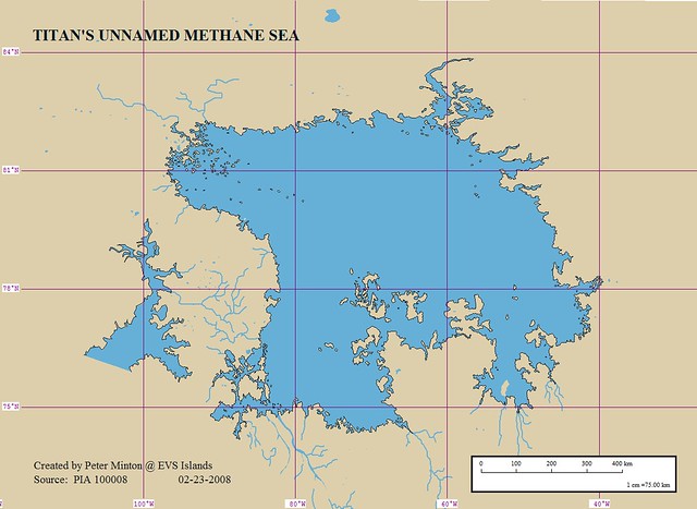
An amateur cartographer named Peter Minton in 2008 created a map of Ligeia Mare (back before it had a name, so ignore the title) and associated islands and rivers from the Cassini images, and the work deserves high praise:
However, the IAU still hasn't named any Titanian rivers, so this active one that feeds into Ligeia Mare is still unnamed:

Punga Mare is close to the North Pole and hasn't been seen completely - false-color:

In the above image, you can also see the swiss-cheese-like terrain of smaller lakes that dot the region, which also occurs in the South polar region. Other views of the North, obviously also in false color (since they just had to color the lakes blue even though they're not) - the second one is notable for being an oblique shot:


Various other Northern lakes, some of which were tracked over time and showed modest seasonal changes:


The largest body of methane in the South is Ontario Lacus (named, obviously, after Earth's Lake Ontario), which is (currently) shaped like a giant footprint, but its mid-dark surroundings indicate it may change significantly over seasons:


It doesn't appear that Cassini has done a lot of detail work in the South pole compared to the North, so we have better images of the Northern seas and lakes. Part of the reason that the Southern bodies are so pitiful at the moment is that its' Southern Summer, so most of the liquid methane and ethane are concentrated in the North. We don't know how drastically that will change as Titan transitions to Southern winter over the course of Saturn's long year, since Cassini has only been in the system for 9 Earth years, and Saturn's year is over three times that long. Unfortunately, Cassini's mission will only last another 4 years (2017), so there won't be a chance to observe a complete cycle.
The Cassini team recently announced that enough of Titan's surface had been radar-mapped to extrapolate topographic maps. The following show the radar-mapped strips and the topography that's been extrapolated from it - it isn't 100% accurate, but as they gather more radar data over the next few years, they will be able to add to it and make it increasingly precise:


And now for the most awesome Titan experience: Images from Huygens as it descended toward Titan were pieced together into a relatively smooth, projection-mapped movie going from just above the haze layer almost to the surface. The video starts out as just computer trajectory modeling showing Titan and Saturn in space, but once the view reaches the Titanian atmosphere it turns into real imagery and you can get a tremendous sense of what it might be like to descend toward Titan. There is some dimensional processing involved, so it's not perfect (some parts are computer extrapolations, and a few bits are fully computer-generated), but it is awesome nonetheless:
---
And that's it for today. In Volume 3, we'll get into the atmosphere, potential for life, and what Titan may some day mean for humanity.
