Part 1, Part 2
This diary is the third of a seven-part series on Maine’s political geography. In this diary, I will discuss the two counties of central Maine: Androscoggin and Kennebec. These two counties border neither the Atlantic Ocean nor Canada, and thus are landlocked by other parts of Maine. Both have substantial populations and several important cities. Maine’s center of population is located in Augusta, which is in Kennebec County.
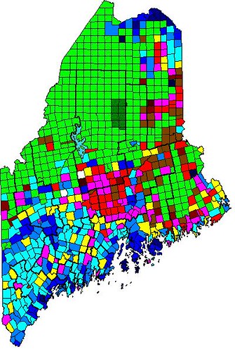
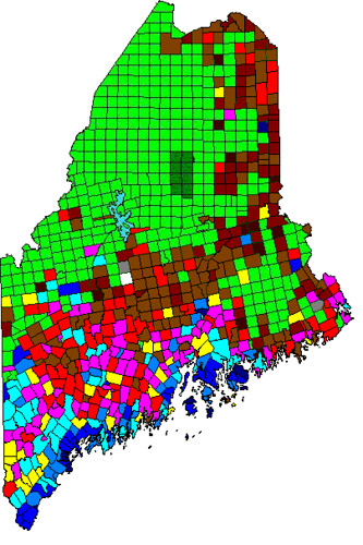
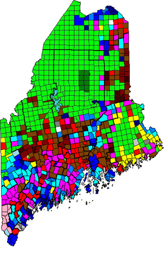
Color code for the maps below (and for all other maps like this that I draw):
Darkest blue: 80%+ for Democrats
Dark blue: 70-79.99% for Democrats
Normal blue: 60-69.99% for Democrats
Lighter blue: 55-59.99% for Democrats
Lightest blue: 50-54.99% for Democrats
Yellow: No candidate received an absolute majority of votes
Pink: 50-54.99% for Republicans
Normal red: 55-59.99% for Republicans
Brown: 60-69.99% for Republicans
Dark red: 70-79.99% for Republicans
Darkest red: 80%+ for Republicans
Gray on the State Senate map represents towns won by independent candidates. White represents towns where no one voted. Green represents uninhabited townships.
Here is a map of Obama’s performance by town in 2012:
Here is a map of Maine’s Question 1 (gay marriage) in 2012:
Here is a map of Maine’s State Senate results in 2012:
Follow me over the fold to begin… with Androscoggin County!
Androscoggin County
If one were to look at the location of Androscoggin County compared to the entire area of Maine, they would probably wonder why I am calling Androscoggin County ‘central Maine’. However, when the fact that more than a third of Maine’s population is in York and Cumberland Counties is taken into account, this designation makes more sense.
Androscoggin is Maine’s fifth most populous county (after Cumberland, York, Penobscot, and Kennebec), and many years ago used to be the Democratic bastion in then-solidly-Republican Maine. However, while Maine now leans Democratic nationally, Androscoggin has gotten more Republican compared to the state as a whole. The county is now about 1.5 points more Republican than the state as a whole, and seems to have leveled off at that. Androscoggin is home to the 2nd and 5th largest cities in Maine: Lewiston and Auburn respectively. The county can essentially be divided into three regions: Lewiston, Auburn, and everywhere else.
Lewiston (Wikipedia) is Maine’s second-largest city. Located on the east side of the Androscoggin River in the center of the county, Lewiston originated as a mill town, and for most of the second half of the 20th century, it was losing population. It is now in the process of turning itself around, a process which has been helped in an unusual way. In the mid-1990s, the federal government resettled a significant population of Somalis and Bantus to Clarkston, Georgia, a suburb of Atlanta. However, the living conditions there weren’t very good, so the Somalis and Bantus looked for somewhere else to move, and decided on Lewiston. While the move wasn’t without some controversy, the Somalis and Bantus have been widely credited with improving the economy of the Lewiston-Auburn area. There are now about 5,000-6,000 Somalis and Bantus in Lewiston, and they wisely chose to settle all across the city rather than cluster in an enclave. Thus, Lewiston is one of the few places in Maine with a non-trivial percentage of racial minorities. Lewiston also contains Bates College, one of the three “Little Ivies” in Maine (the others are Bowdoin, in Brunswick, and Colby, in Waterville). This combination of mill workers (who lean Democratic, as we will see in other towns as well), Somalis and Bantus, and a college, results in the town having a substantial Democratic lean. Lewiston voted more than 60% for Obama in both 2008 and 2012.
Auburn (Wikipedia) is Maine’s fifth-largest city, and located directly across the Androscoggin River from Lewiston. Despite Lewiston’s larger population, Auburn is the county seat of Androscoggin County. Auburn is less blue-collar than Lewiston, and so has slightly less support for Democrats. The city voted 58% for Obama in 2008 and 57% for him in 2012. Auburn, like the rest of the county outside of Lewiston, is overwhelmingly white; the Somalis and Bantus seem to be staying in Lewiston. Auburn seems to be a relatively boring city, and so, without further ado, I will move on to the rest of the county.
Despite my clumping the whole rest of the county into one region, there are many different parts of it. Lisbon, a sizable town located between Lewiston and Brunswick, is also blue-collar, but doesn’t have either a minority population or a college, so it is much less Democratic than Lewiston. The towns of Turner and Greene, located north of Lewiston/Auburn, both lean Republican. Poland, the westernmost town in the county, is moderate in the mold of neighboring Raymond and Casco. The two northernmost towns, Livermore and Livermore Falls, both lean Democratic; Livermore Falls substantially more than Livermore. Livermore Falls is similar to neighboring Jay and nearby Rumford and Mexico; they are all small mill towns with strong union presences. These towns all vote strongly Democratic; I will talk more about them when I get to Northwestern Maine.
Androscoggin County is relatively socially conservative when it comes to gay marriage. The downside of using blue-collar factory workers as the Democratic base is that these workers are generally against gay marriage. The county voted 60% against gay marriage in 2009, and 54% against it in 2012. In 2012, only one town, Auburn, voted for gay marriage, probably because it is less blue-collar than the rest of the county. Even Lewiston, home to Bates, voted against gay marriage both times. The Livermore/Livermore Falls area voted strongly against gay marriage despite its Democratic nature, because it is so blue-collar. This is a trend that we will see more of in future diaries in this series.
Androscoggin County contains two whole State Senate districts and most of a third. Lewiston is a State Senate district in and of itself (old 16th/new 21st), the only one-entire-town State Senate district in Maine. The district is heavily Democratic and represented by Margaret Craven (D). The old 15th/new 20th contains Auburn, Durham, Poland, and New Gloucester (the last of which is in Cumberland County). This district leans Democratic, and then-incumbent Lois Snowe-Mello (R-Poland) was defeated last year by a 53.5-46.5 margin by John Cleveland (D-Auburn). In redistricting earlier this year, this district lost Durham and gained Mechanic Falls and Minot, resulting in the district shifting a quarter of a point to the right. Cleveland underperformed Obama by less than a point last year, so he should be relatively secure, although he’s not safe. The final Androscoggin County district contains the entire remainder of the county, and it is an evenly-divided district; Obama got 49.9% of the vote there last year. State Senator Garrett Mason (R-Lisbon) won an incredibly close race last year, victorious by only 28 votes. Mason won his hometown of Lisbon as well as Wales, Greene, and Turner, while losing Mechanic Falls, Minot, Livermore, Livermore Falls, Leeds, and Sabattus. Mason is a right-winger and a graduate of the ultra-fundamentalist, unaccredited Pensacola Christian College, so despite his district’s moving three-quarters of a point to the right in redistricting, he is still vulnerable, and Democrats should strongly target this seat. Mason is considering running for Congress in ME-02, so this would be a good opportunity to both end his political career and take back his seat.
Kennebec County
Kennebec County is true Central Maine. It is the fourth-most-populous county in Maine, and one whose politics are just a point to the right of those of Maine as a whole. Augusta, located in the center of the county, is the capital of Maine, and Waterville, another important city, is located in the north of the county. Kennebec can be divided into three regions: the Augusta area, the Waterville area, and the western part of the county away from the Kennebec River.
The Augusta area consists of Augusta and the smaller towns clustered south of it along and near the Kennebec River. Of these towns, the most Republican towns are the ones that do not border the river, namely Litchfield, West Gardiner, Pittston, and Windsor. These towns are largely rural, and don’t have as much Augusta influence as the towns along the river. Manchester, located just west of Augusta, is a swing town, as is Chelsea, whose Kennebec riverfront is less developed. Next up are the trio of Farmingdale, Randolph, and Gardiner, three towns that are small in area but mostly developed and generally Democratic. Then comes the colossus here, Augusta itself. Compared to most state capitals, Augusta is not very Democratic, but it still voted 59% for Obama in both 2008 and 2012. Besides the state government, Augusta doesn’t have much else of note, and it’s a pretty boring city. Just south of Augusta is the tiny, artsy enclave of Hallowell, which is the most Democratic town in Kennebec County. Hallowell is kind of like a chunk of Camden that was somehow transported to two miles south of Augusta. It’s not like anywhere else in Kennebec County, and the only place in the county that it votes similarly to is Waterville.
Speaking of Waterville, the Waterville area is directly north of Augusta along the Kennebec River. Most of the towns here are relatively moderate, with the exception of the small, strongly Republican town of Albion (birthplace of Elijah Lovejoy) and heavily Democratic Waterville. Waterville’s immediate sphere of influence contains itself, Winslow, Oakland, and Fairfield; Fairfield is in Somerset County but the rest are in Kennebec. Waterville used to be a mill town (it is located next to a waterfall on the Kennebec River) but now has a significant educational sector, including Colby College, a Little Ivy, and Thomas College, a career-oriented place. Since Waterville is less than half the size of Lewiston, its educational sector plays a much larger role in the politics of the town, and thus the town is strongly Democratic. This Democraticness hasn’t really rubbed off on any of the surrounding towns, however, since none of them voted more than 55% for Obama last year.
The western part of Kennebec County is the least-populated area; it includes the Belgrade Lakes area and the Winthrop area. This region generally leans Democratic, and every town in this region voted for Obama last year. This is a vacation area; there are many lakes here, and almost all of them are lined with vacation homes that people use in the summer; these people then flee down to Florida for the winter. (If you ask me, these people don’t know what they’re missing.) The town of Wayne is generally Democratic, but, ignoring random fluctuations, this whole area is about uniformly 54-55% Democratic. Winthrop is the largest town here.
Kennebec County as a whole leans socially conservative, but it is not uniform. The county voted 57% against gay marriage in 2009, but this dropped to 51% against in 2012. The Augusta area is a mixed bag: Hallowell strongly supported gay marriage, while Augusta was evenly divided and most other towns were against it. In the Waterville area, only Waterville supported gay marriage, possibly due to the liberal college students and faculty there. Western Kennebec County was relatively evenly divided; Wayne, Readfield, Winthrop, Rome, and Vienna voted for gay marriage while Monmouth, Fayette, Mount Vernon, and Belgrade voted against it. Western Kennebec is less blue-collar than the rest of the county (with the exceptions of a few towns that I already pointed out), which may account for its more socially liberal nature.
Kennebec contains two whole State Senate districts, most of a third, and part of a fourth district that is mostly in Franklin County. I will discuss only the three districts that are mostly or entirely in Kennebec County. The first of these, the old 21st/new 14th, consists of all the towns south of Augusta as well as Manchester, Winthrop, and Monmouth. This was an open seat last year, and it was very narrowly won by Patrick Flood (R-Winthrop). Flood lost all the river towns south of Augusta, but he made up for it with a massive 70-30 margin in his hometown of Winthrop to win 50.7-49.3. His district moved 0.6 percent toward the Democrats in redistricting, and so Flood is very vulnerable. With a good candidate, we should be able to take this seat next year. Kennebec’s second State Senate seat, the old 24th/new 15th, contains Augusta, the towns just north of it, and Oakland. This district was Libby Mitchell’s district before her ill-fated gubernatorial run in 2010, and that year it was taken by Roger Katz (R-Augusta). Katz seems to be very popular in his district, and he won 62 percent past year, so despite the fact that this district voted 54.6 percent for Obama, he seems to be safe. Kennebec’s third State Senate seat, the old 25th/new 16th, is based in Waterville and had been represented by Democrats for a long time. Then, in 2010 Thomas Martin (R-Benton) won this seat when it was open, mainly by winning huge margins in the smaller towns and getting 40 percent in Waterville. This district, which voted 57% for Obama in 2012, was always one of the Democrats’ top targets in 2012, and our nominee, Colleen Lachowicz of Waterville (of World of Warcraft fame), defeated Martin 53-47. Lachowicz lost every town except for Waterville, but she won Waterville by such a large margin that it negated all the rest of the towns. Lachowicz’s district was made a half-point more Democratic in redistricting, so she should be pretty safe.
This concludes Part 3 of my series. In the next part, I will discuss Down East: Hancock and Washington Counties.
I hope you enjoyed reading, and I welcome any feedback or questions!

