CONTENT WARNING: This diary revisits and focuses on the destruction of a peaceful city in Ukraine. There are no graphic depictions of individual human suffering, but one could argue the pictures presented here are representative of human suffering on a grander scale. I am acutely aware of "war porn" and "disaster porn", and I sincerely hope people get more from my diary than just "gee, lookit how destroyed this place is!". I want to illustrate that these are real people in a real place, and show the technology available to us to connect to others and relate our personal experiences with others across the globe. That said, if you don't want to see images of destroyed buildings compared to how they once were, you may want to skip this one. Thanks for reading!
When I wrote my first (ever) diary Ghosts, I was stricken by the difference in what Google Maps (Maps) showed and what was actually going on in Ukraine. We have been witnessing an endless parade of death and destruction served up via Twitter and Telegram; woe and misery and sorrow interspersed with far too few moments of compassion, hope and relief. And yet… on Maps, no sign of any of it. Zooming to Mariupol, Maps revealed a tranquil, mid-sized costal city of about half-a-million people that could have been located anywhere; houses and apartment blocks interspersed with trees sprinkled around like green cotton balls, and a modest beachfront on the Sea of Azov. The only real features to distinguish this aerial view from, say, Milwaukee, Wisconsin, Christchurch, New Zealand, Mar Del Plata, Argentina, Kavala, Greece or Rødvig, Denmark, are the two rusty scabs on the landscape that are Azovstal Steelworks and Magnitogorsk Steelworks, both famous for the role they played in the Ukrainian defense of the city. Aside from the outdated images of intact buildings, Maps also played host to a myriad of “photospheres” sprinkled around the city, 360-degree panoramas that anyone people with sufficient technical knowledge can make, upload, and share with the world. One of the photospheres was recorded on February 2022, mere weeks (or possibly days) before Russia kicked off their illegal invasion of this sovereign nation. I was so moved by this image, I wrote that first diary (the link to the photosphere is in that diary, but here it is again).
When it comes to Google Maps, I understand that it can take months or years for certain areas of the world to get updated, and I confess I was waiting with bated breath for Mariupol to update to see for myself how bad the destruction to the city was. Well, The satellite imagery of Mariupol has updated, and it's just about as tragic as I had expected.
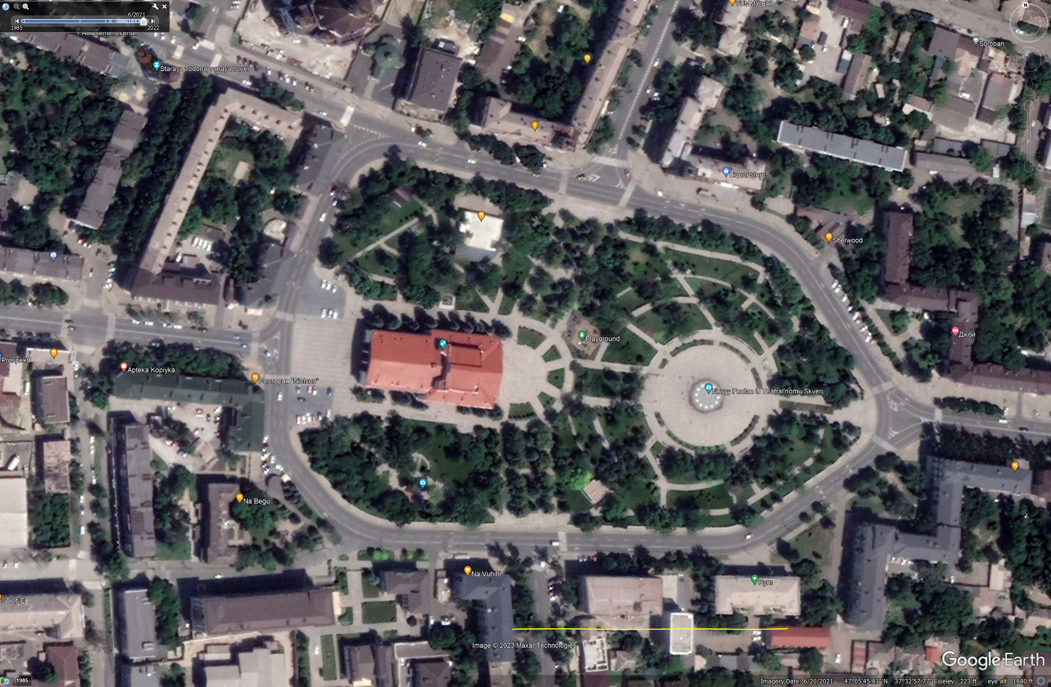
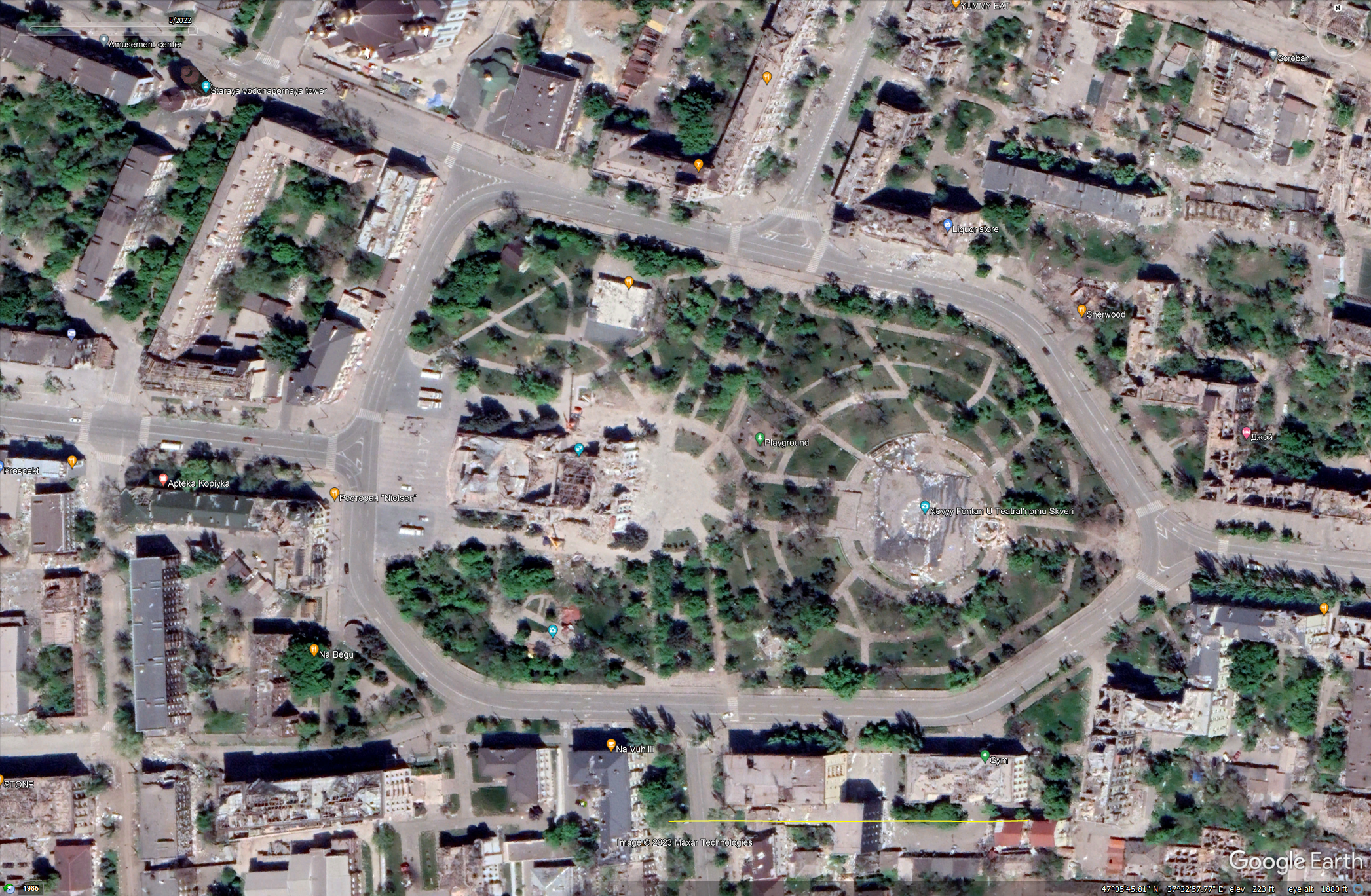
It's a little uncanny to be able to zoom out from my doorstep, soar across the globe, and land right at the remains of the Mariupol Drama Theater, complete with "дети" (children) written clear as day in the ground in front. It draws a clear, unbroken line that connects me, my life, my oh-so-familiar surroundings to that place that I don't think can be replicated elsewhere. To me, it is a novel way to make the war, its consequences, and the human cost real and relatable.
Truth be told, I'm not certain what I want to say about this destruction laid bare. I'm not sure what I'm even supposed to say. I’m not an expert on war or Ukraine or human rights abuses or even Google Maps. But I can say with certainty that it's horrific. I can't imagine what it's like to actually be there. To step around the broken concrete (Don't snag your clothes on the exposed rebar!), to smell the air, acrid with the stench of hot metal and detonated explosives and God-knows-what-else. To hear the eerie silence of an abandoned place, punctuated with the distant sounds of war. Before the Maps update, I felt this dissonance between what I saw and what I knew to be true. When I finally saw the new maps- when those realities aligned, my jaw literally dropped. The extent of the destruction is astounding. I hope it's the closest I ever get to really experiencing it.
I don’t know the date the Google Maps satellite pictures were taken, but by using the similar-but-different program (executable, app- pic your word de jour) Google Earth (Earth), one can not only see the date of the satellite image, but one can scrub back in time to see how things looked before. It's a little confusing how Google maintains these two apps; Maps is browser-based while Earth is primarily a downloadable .exe (though it does have a browser-based version, which makes it more confusing). At first blush, they look identical, but they have different functionality (Maps has street view, for instance, while Earth has the aforementioned history scrubbing). It is worth noting that the most recent images available on Google Earth are from May 2022, three months after the invasion and during the worst part of the Azovstal fighting (the below is extracted from wikipedia):
- On 4 May [2022], Russian troops claimed to have entered the steel plant after launching an all-out offensive.
- On 7 May [2022], Deputy Prime Minister Iryna Vereshchuk stated that "all women, children, and the elderly" had been evacuated from Azovstal.
- According to The New York Times, the Azov Battalion was ordered to surrender by the Ukrainian General Staff on 16 May [2022], who said it was necessary "to save the lives of the personnel".
- On 17 May 2022, 53 seriously injured people surrendered and were evacuated from Azovstal to a medical facility in Novoazovsk and 211 people were taken to Olenivka through the humanitarian corridor, marking the end of the combat mission in Mariupol and the defense of the Azovstal plant after 82 days of fighting.
While all this was happening, these satellites were passing overhead, silently cataloguing it all.
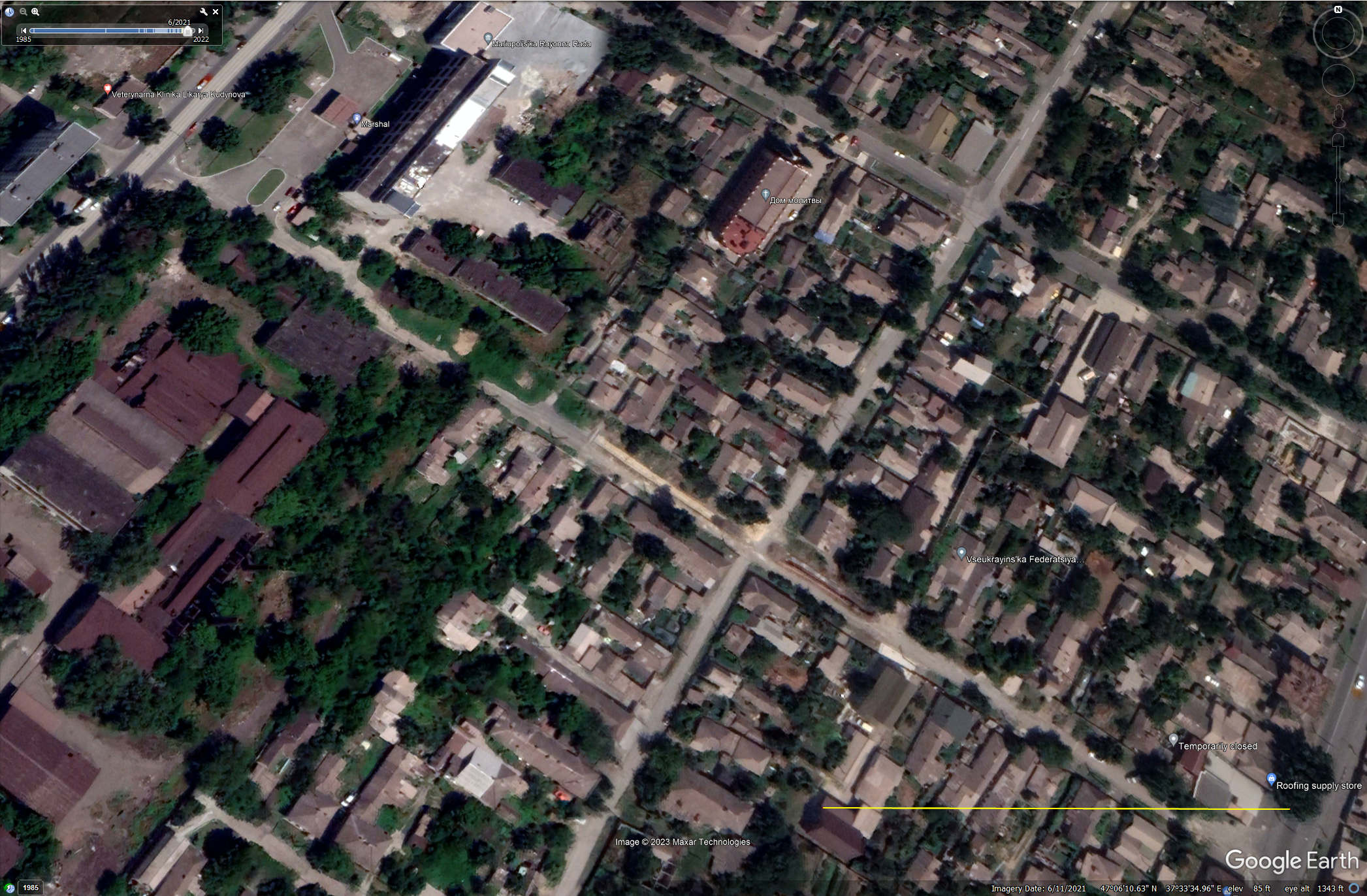
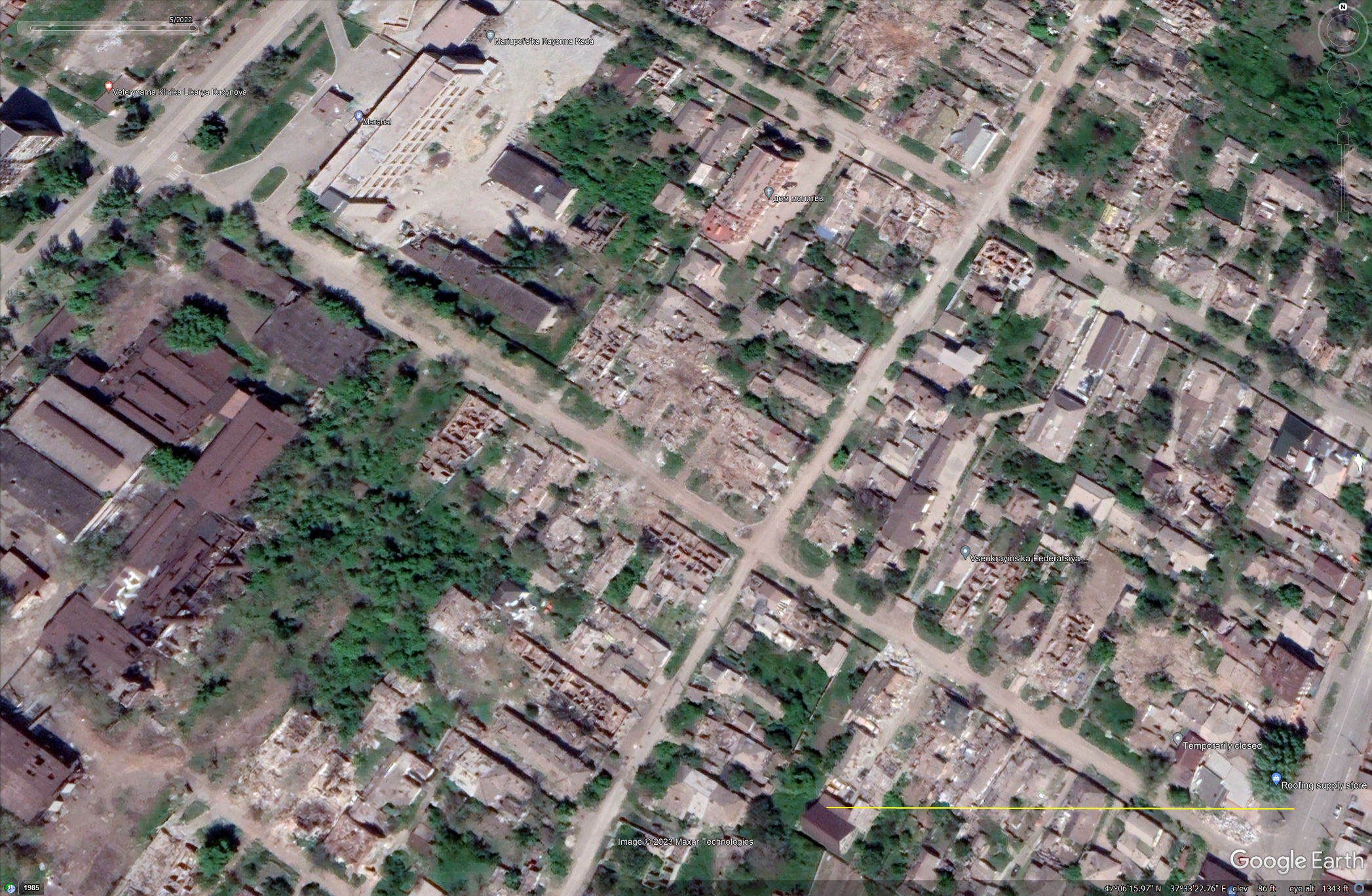
I used Google Earth to take some before and after screenshots. Here we can see the way things are, they way things were, and dream about the way things will be again. I’ll offer these images with minimum comment so they can speak for themselves. The post-invasion images are from May, 2022. The pre-invasion images are from June, 2021. The yellow bar on the bottom right of each image is 500 ft. You should be able to open the images in a new tab to see their full size.
Oh, and in case you're wondering, the most recent satellite images on Earth of Bakhmut are also from May 2022. According to Wikipedia, the Battle of Bakhmut main Russian assault began in August 2022, but shelling of the city started in May 2022 (the month the satellite pictures were taken). I see no signs of artillery damage, leading me to assume the shelling began after the images were captured. In the reality Google Earth presents, at least, Bakhmut is still whole and thriving. Depending on peoples' appetite for this kind of diary, I might do another one of these on Bakhmut when the satellite images update.
Last thing: if you need a palate cleanser after seeing these images, I have provided some Google Maps links to show you what an interesting and varied world we live in that is (for the most part) full of joy, laughter, beauty, and perhaps most importantly, people just living, going about their lives secure in the knowledge that a rocket or artillery shell won't suddenly drop on their heads. I can't wait until the Ukrainian people can join us once again in such mundanity.
Interesting places:
Thimphu, Bhutan
Jakarta, Indonesia
Dingwall, Scotland
Guatemala City, Guatemala
Nairobi, Kenya
Milan, Italy
---------
1. The drama theater
2. A crossroads
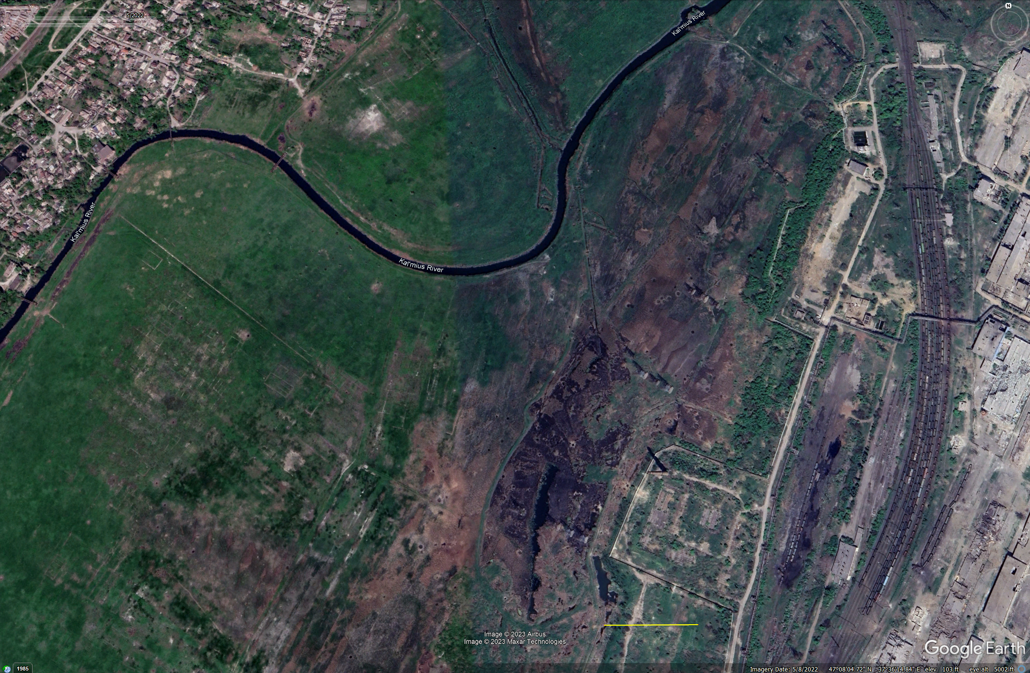
3. Riparian zone of the Kal’mius River (just north of Azovstal)

4. Azovstal. Note the scale bar. The top building is over half a mile long at it longest part.


5. Field on the western edge of the city.

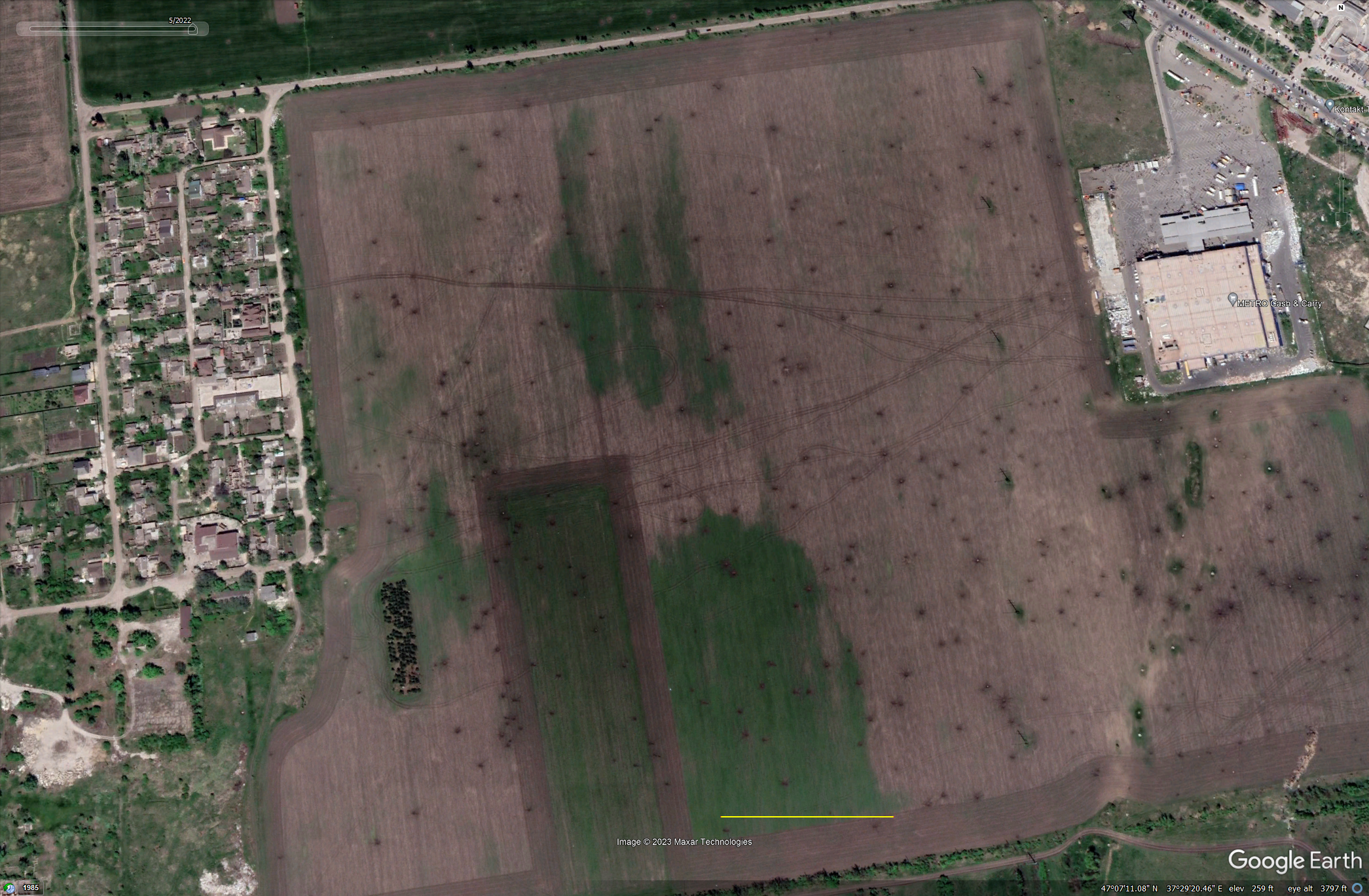
6. Portcity Shopping Mall. I think what is happening here is humanitarian aid. My first thought was looting, but the trucks in the parking lot and the cars parked in orderly fashion on the road north of the mall leads me to believe it’s an aid stop. There are a LOT of people here. Note the field to the left of the mall is the same field in image 5 (and the mall is visible in that image, too).


I can’t wait revisit this and include the rebuild before and afters…


