Part 1, Part 2, Part 3, Part 4, Part 5
This diary is the sixth of a seven-part series on Maine’s political geography. In this diary, I will discuss the three counties of Northern and Northeastern Maine: Piscataquis, Penobscot, and Aroostook. These are the three remaining counties of Maine that I haven’t discussed yet. They are all very large in area, but with widely varying populations (Piscataquis is the least populous county in Maine, while Penobscot is the third most populous). The hub of this area is Bangor, the third-largest city in Maine. Outside of the Bangor area along the Penobscot River, no other town reaches 10,000 people.
This is an area of great political diversity, and great diversity even among factions of the same political party. Democrats range from college professors to mill workers to French speakers, and Republicans range from suburbanites to small-towners to middle-of-the-woods downscale people. Thus, the political geography of this area is fascinating and very complex.
Color code for the maps below (and for all other maps like this that I draw):
Darkest blue: 80%+ for Democrats
Dark blue: 70-79.99% for Democrats
Normal blue: 60-69.99% for Democrats
Lighter blue: 55-59.99% for Democrats
Lightest blue: 50-54.99% for Democrats
Yellow: No candidate received an absolute majority of votes
Pink: 50-54.99% for Republicans
Normal red: 55-59.99% for Republicans
Brown: 60-69.99% for Republicans
Dark red: 70-79.99% for Republicans
Darkest red: 80%+ for Republicans
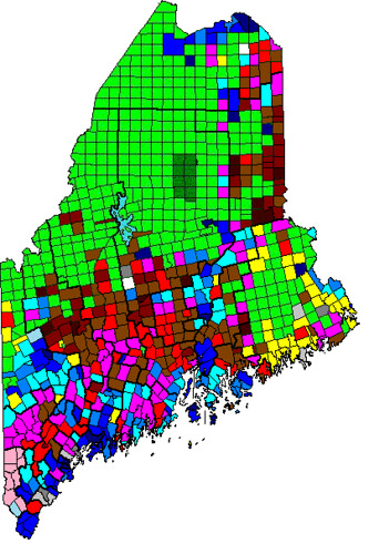
Gray on the State Senate map represents towns won by independent candidates. White represents towns where no one voted. Green represents uninhabited townships.
Here is a map of the counties of Maine.
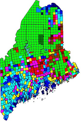
Here is a map of Obama’s performance by town in 2012:
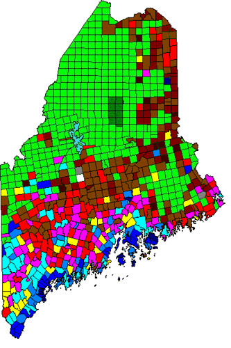
Here is a map of Maine’s Question 1 (gay marriage) in 2012:
Here is a map of Maine’s State Senate results in 2012:
Follow me over the fold to begin… with Piscataquis County!
Piscataquis County
Piscataquis County is the least-populous, least-densely-populated, and most Republican county in Maine. It is the only county in Maine to vote for either John McCain or Mitt Romney, and is consistently the most Republican county in statewide elections as well (it only narrowly voted for Angus King over Charlie Summers last year, despite King’s landslide win statewide). Only about 18,000 people live in the county, and the largest town and county seat, Dover-Foxcroft, has only 4,213 people. Due to Piscataquis County’s small population, it has no real regions, and so I will discuss it as a whole.
Most of Piscataquis’s important towns, such as Dover-Foxcroft, Milo, and Guilford, lean Republican. This Republicanism isn’t quite as strong as the areas of rural Penobscot County to the south, but most of the county is an extension of those Republican areas. The one major exception to this trend is the town of Greenville, at the south end of Moosehead Lake. Greenville leans Democratic, due to the resort people who live there, and the fact that the Big Squaw Mountain ski resort is nearby certainly doesn’t hurt.
Besides Moosehead Lake, the other important tourist area that Piscataquis County has is Baxter State Park (BSP). BSP, located in the uninhabited northeastern part of the county, contains Katahdin, the highest mountain in Maine, as well as many other tall mountains. BSP was given to the people of Maine by former governor Percival Baxter, who proclaimed that BSP must remain in its natural state for the enjoyment of future generations of Mainers. What this means is that there are no commercial establishments, no buildings larger than a log cabin, and even no paved roads in BSP. Even the park headquarters is located 18 miles away in Millinocket, the nearest town (which is in Penobscot County). In addition, the Park bans pets and strictly limits the number of visitors who can be in the park at the same time. So my advice is, if you want to visit BSP, plan to arrive at the gate at 6 AM.
Pardon my waxing effusive about BSP; I’ve been there and it’s an amazing place. Now, back to politics.
Piscataquis County is strongly socially conservative; in fact, it voted more against Question 1 last year than any other Maine county except Aroostook. In 2009, it voted 67 percent against gay marriage, and in 2012 it voted 63 percent against, so at least it is moving in the right direction, though it still has a ways to go. This vote was spread pretty evenly throughout the county, as only a few towns diverged more than a few points from the county average either way.
Piscataquis County finds itself in a strange position with regard to its State Senate district (the old 27th/new 4th). A majority of the population of the district is in Piscataquis County, however neither its Republican incumbent nor its Democratic challenger last year were from Piscataquis. The incumbent, Douglas Thomas (R), is from Ripley, a small town in Somerset County, while the challenger, Herbert Clark (D), was a State Representative from Millinocket, in Penobscot County. In that race, Piscataquis’s Republican lean showed clearly, and Thomas won the county 59-41. However, the end result of the race was only 54-46 for Thomas, because despite Thomas’s winning big in the small Somerset County portion of the district, Clark did extremely well in the Millinocket area, getting 78 percent in Millinocket, 74 percent in East Millinocket, and even 63 percent in normally-Republican Medway. In the 2011 redistricting, Thomas lucked out, losing Millinocket and gaining some Republican areas of Penobscot County in return, moving the district from 46 percent Obama 2012 to 44 percent Obama 2012. Thus, the district is likely to be safely Republican in the future.
Penobscot County
Penobscot County is the colossus of this region. It is the third-most-populous county in Maine, and contains the Maine’s third-largest city (Bangor) and all of its suburbs and surrounding towns. It is the electoral base for the 2nd Congressional District, and both current Congressman Mike Michaud and State Senator Emily Cain, who is running for Michaud’s seat (Michaud is running for Governor), are from Penobscot County. There are two distinct regions in Penobscot County: the rural western part of the county, and the towns along the Penobscot River. Thus, I will first talk about the rural western towns, and then start at the south end of the Penobscot River and move north along the river.
The rural western towns in Penobscot County constitute the most populous Republican area in Maine, and it is easily seen on the 2012 Presidential election map. This region mostly consists of towns with between 1,000 and 5,000 people. The southeastern part of the region blends into the Bangor suburbs, with the town of Hermon as the boundary; it’s both a rural town and, increasingly, a Bangor suburb. Hermon also gave both McCain and Romney their largest popular-vote margins of victory of any town in Maine, and all the runners-up in both elections are in this area. As I have mentioned previously, this area spills over into the adjacent parts of Somerset and Piscataquis County, but interestingly, not Waldo County. This area is monolithically and consistently Republican at all levels, and it is this area that is to blame for Maine’s 2nd district being relatively swingy. If there was ever a need to pack as many Maine Republicans as possible into one district, this is where that district would be.
The political geography of the Penobscot River towns is much more complex. Starting from the south, the first two towns we encounter are Hampden, on the west bank, and Orrington, on the east bank. Both of these are suburban towns that lean Republican, but are not as intensely Republican as towns like Hermon. Hannibal Hamlin, Abraham Lincoln’s first Vice President, was from Hampden. Then, continuing north, we get to Bangor itself. Bangor is reliably, but not hugely, Democratic, and it voted about 58 percent for Obama last year. In last year’s elections, it went solidly blue, and now its State Senator and all four of its State Representatives are Democrats. However, Bangor is not just a large mill town (though forestry is a large part of its history). It has several small colleges, an international airport, two large hospitals, and a redeveloped central area that is thriving. Thus, it is much more of a middle-class city than, say, Lewiston. Its twin city, located directly across the Penobscot River, is Brewer. Brewer is mostly suburban and leans Republican, however Obama performed better there in 2012 than he did in 2008, so it may be trending Democratic. However, as long as Brewer votes Republican, it is usually the largest town in Maine to vote for Republicans (including McCain and Romney). Just upriver from Bangor and Brewer is the tiny town of Veazie, wedged between Bangor and Orono. It’s a mainly suburban town that leans Democratic.
Continuing upriver from Veazie, we get to Orono, home of the University of Maine. Thus, unsurprisingly, Orono is strongly Democratic; in fact, it is one of the most Democratic towns in Maine. A large chunk of Orono is located on Marsh Island, a large island in the Penobscot River, and thus, interestingly, the University of Maine is the only flagship public university in the country that is located on an island (excluding Hawaii, obviously that doesn’t count because the entire state consists of islands). UMaine students have been active with environmental and LGBT-related issues, and thus the town has a very liberal atmosphere that shows itself especially on ballot questions such as Question 1 last year. Across the Penobscot River from Orono is Bradley, a former mill town that is becoming a suburb of Orono and Old Town.
Moving north from Orono, but still on Marsh Island, we get to the aforementioned Old Town. Old Town marks the northern edge of the Bangor area and it is, in many ways, the northernmost town of the Northeast Megalopolis. Nowhere between Old Town and Petersburg, Virginia will you find the sort of virtually uninhabited areas and widely-spaced, tiny towns that exist north of Old Town. Old Town is best known for the eponymous canoe company, and has transformed itself from an old mill town to an outdoor-oriented community centered around Old Town Canoe Company (which now sells much more than just canoes). Many people who live in Old Town work in Orono, for UMaine, or in Bangor, for one of the hospitals there. One other interesting feature of Old Town is that it is the home of the Penobscot Indian Island Reservation. More than 500 Penobscots live in Old Town, mostly on Indian Island (another island in the Penobscot River), and they help Old Town be the solidly Democratic town that it is. The east bank towns of Milford and Bradley also both lean Democratic.
Moving north, there are only a few other towns of note. The next town we get to is Howland, which leans Democratic. Next up is Lincoln, a little bit larger than Howland, which is more Republican. Lincoln is very downscale, and it is kind of a transition from the Democratic-leaning Howland to the strongly-Republican, very downscale southern part of Aroostook County. North of Lincoln are the three northernmost towns on the Penobscot River: Medway, East Millinocket, and Millinocket. Medway, the smallest, is Republican, while East Millinocket (the hometown of Mike Michaud) leans Democratic. Millinocket, the largest, is a mill town with a consistent, but not that strong, Democratic lean. Millinocket is the closest town to Baxter State Park, and so one might think that it was populated by the kind of outdoorsy liberals who live in Vermont, but this impression is entirely mistaken. Millinocket is an economically-depressed town that never was able to take advantage of its proximity to BSP and Katahdin.
Penobscot County as a whole leans socially conservative, but there are wide variations throughout the county. Penobscot voted 59 percent against gay marriage in 2009, and this dropped to 53 percent against in 2012. Unsurprisingly, the strongest support for gay marriage comes from Orono, however both Bangor and Old Town supported gay marriage by good margins, and even Hampden, a town that Romney won, narrowly supported gay marriage. However, in both the western rural towns and the Penobscot Valley north of Old Town, gay marriage did poorly. Echoing the results in places like Rumford and Jay, the Millinocket area voted strongly against gay marriage, since the Democrats there are socially-conservative unionized mill workers. The swing towns on gay marriage seem to be the towns across the river from Bangor, Orono, and Old Town, and those towns all voted narrowly against gay marriage.
Penobscot County contains three whole State Senate districts (old 30th/new 5th, old 32nd/new 9th, and old 33rd/new 10th), a majority of a fourth (old 31st/new 8th), and a small portion of a fifth. The old 33rd/new 10th is the most solidly Republican State Senate district in Maine, containing most of western Penobscot County. It is represented by Andre Cushing (R-Hampden), and it voted only 43 percent for Obama last year. Cushing got 61 percent of the vote last year, losing only the towns where his opponent was from, so he is safe. The old 32nd/new 9th contains just two towns: Bangor and Hermon. This was one of the most fiercely-fought districts last year, and in the end Democrat Geoffrey Gratwick won a 51.5-48.5 victory over Republican incumbent Nichi Farnham. The district voted 56 percent for Obama, so Gratwick should be relatively secure barring a Republican wave (as 2010 was the only reason why Republicans held this district in the first place). The old 31st/new 8th has a majority in Penobscot County, but also has a piece in Hancock County, and the election results last year were polarized by county lines. The Democrat, from Bucksport in Hancock County, won five towns in Hancock County, some by large margins, while the Republican, Edward Youngblood of Brewer, dominated the Penobscot County portion. Since the Penobscot County portion is larger than the Hancock County portion, it wasn’t that close in the end; Youngblood won 56-44. This district moved a point to the right in redistricting, so Republicans should be safe. Finally, the old 30th/new 5th is Emily Cain’s district, and contains Orono, Old Town, and the Penobscot River towns north of Old Town. Cain is very popular in her district, getting 63 percent of the vote last year even though Obama only won 56 percent there. Even though Cain is running for Congress, this district should stay in Democratic hands since it moved three points to the left in redistricting, mainly by tossing some conservative rural towns and gaining the Millinocket area.
15 counties down, one to go. That leaves us with…
Aroostook County
Aroostook County is really a region of its own in Maine. It has the largest land area of any county east of the Mississippi, a strong regional identity that results in Mainers referring to it as simply “The County”, and an interesting pattern of political geography that results largely from ethnicity. Aroostook is by and large a rather downscale region, and it is one of the only counties in Maine that is losing population. There are three distinct regions of Aroostook County: southern Aroostook, central Aroostook, and northern Aroostook.
Southern Aroostook County is the most conservative section of The County. It consists of all the towns south of Presque Isle, and contains about a quarter of Aroostook’s population. The largest and most important town here is Houlton, which serves as the northern terminus of I-95 in the U.S. Houlton has a significant (10 percent) population of Native Americans, mostly Maliseets. This serves to moderate its politics slightly, though Houlton still leans Republican. The rest of this region consists of tiny, remote, heavily forested towns, and these towns are all strongly Republican. The type of conservatism here (along with similar areas in Piscataquis, Penobscot, and Washington counties) is not a religious one, but more of an economically libertarian one. These people don’t want “big government” poking around in their houses (though they are perfectly fine with denying gay people the right to marry, but that’s a different story). This area is much less French in ethnicity than the areas to its north.
Moving north, we get to Central Aroostook County. This region contains Presque Isle, Aroostook’s largest town; Caribou, Aroostook’s second largest town; Fort Fairfield, another important town; and many smaller towns to the west. This region contains about half of Aroostook’s population, and is politically moderate. Caribou and Presque Isle both voted between 50 and 55 percent for Obama in both 2008 and 2012, and the whole region voted similarly to those two towns. This region is one of the largest potato-growing areas in the entire U.S., producing the potatoes that Maine is famous for. As a result, this is one of the least forested areas in the entire state. As I said earlier, Aroostook as a whole is pretty downscale, however Caribou and Presque Isle are less downscale than the rest of the county. Presque Isle has a small branch campus of UMaine that helps its economy, while Caribou used to be the service center for the Loring Air Force Base in nearby Limestone, which closed in the 1990s. This region contains a larger percentage of Franco-Americans than Southern Aroostook, but not as much as Northern Aroostook.
Northern Aroostook County consists of all the heavily Franco-American towns along Maine’s northern border with Canada, and contains about a quarter of Aroostook’s population. The three largest towns here are Madawaska, the northernmost town in New England, and across the St. John River from Edmundston, New Brunswick; Fort Kent, which is home to another branch campus of UMaine, and Van Buren, another town on the St. John River. It cannot be emphasized enough just how French-influenced this area is; in Madawaska, 83 percent of residents speak French at home. This area is also strongly Democratic, with several towns voting more than 70 percent for Obama in both 2008 and 2012, and most other towns voting at least 60 percent for Obama. The economy of this region revolves around paper mills, logging, and trade with Canada, so the Democrats here are downscale and unionized, similar to towns like Rumford and Millinocket (but more French).
One consequence of Aroostook’s remoteness and downscale economy is that it is very socially conservative. Aroostook voted a whopping 73 percent against gay marriage in 2009, and this number dropped only to 67 percent against in 2012. The interesting thing is, despite all the differences I mentioned between the three regions of Aroostook, there are few differences in how they vote on gay marriage; almost every town is within ten points of the county average. Not a single town in Aroostook voted for gay marriage, and only one came close (Masardis), however Presque Isle and Fort Fairfield managed to get support for gay marriage into the 40s, probably due to their being more outward-looking than the rest of the county. But even the Democrats here oppose gay marriage, and it will be a long time before that changes.
Aroostook County is home to two State Senate districts: the old 34th/new 2nd, and the old 35th/new 1st. This fact, combined with the populations of each of the regions, creates a slight problem: the old 34th/new 2nd includes all of southern Aroostook and half of central Aroostook, while the old 35/new 1st contains the other half of central Aroostook and all of northern Aroostook. Thus, although central Aroostook is just the right population for a State Senate district, it does not get one and is instead evenly split between the two districts, both of which are dominated by the other regions. Therefore, central Aroostook does not have representation in the State Senate (something that the residents would like to change, but are unable to).
The old 34th/new 2nd is represented by Roger Sherman, a Republican from Hodgdon, a town just south of Houlton. Sherman is extremely popular in southern Aroostook, and he got more than 70 percent in many of those towns last year, however even though he won 62-38 overall, he was destroyed in Ashland and Masardis (as his opponent was from that area), and he even narrowly lost Presque Isle. However, the fact that he still won by such a wide margin shows that Presque Isle and the portions of central Aroostook in this district really have no say over who its Senator is. The old 35th/new 1st is represented by Democrat Troy Dale Jackson of Allagash, a tiny town west of Fort Kent. Jackson is the current Senate Majority Leader, and he has taken a leading role in opposition to Paul LePage. For this, Jackson has been on the receiving end of several insults from LePage, including a sexually explicit one that I will not write (but will link to). Jackson is running for Congress in 2014 in ME-02, and will face the aforementioned Emily Cain in the Democratic primary. Despite northern Aroostook’s dark blue hue, Jackson faced a close race last year. His opponent was from Caribou, and won the portion of central Aroostook by a wide margin, however Jackson did well enough in northern Aroostook to eke out a 51.5-48.5 win. In addition, politicians from Aroostook County often have a hard time winning voters outside The County.
This concludes Part 6 of my series. I hope you enjoyed reading, and I welcome any feedback or questions!

