If only life were like a merry-go-round, because you know with 'those kind of rides' -- someone can eventually find the Off-Switch, if something goes awry.
I would wager there are some Californians searching for one of those, right about now.
California drought: El Niño chances fall again
by Kurtis Alexander, sfgate.com -- September 4, 2014
Hopes of an almighty El Niño bringing rain to a drought-stricken California -- with its fallow fields, depleted streams and parched lawns -- were further dashed Thursday. The National Weather Service, in its monthly El Niño report, again downgraded the chances of the influential weather pattern occurring in the fall or winter.
The odds were 80 percent in May, but were placed between 60 and 65 percent this week.
Meanwhile, the agency also announced that the much-needed weather event is likely to be weak instead of moderate in strength -- another retreat from the more robust projections made earlier this year that fueled speculation that California's three-year dry spell might be snapped.
[...]
El Niño and La Niña Years and Intensities
Based on Oceanic Niño Index (ONI)
Jan Null, CCM
Updated August 7, 2014
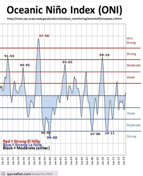
Well if you discount that last "weak El Niño event" back in 2012, that lack of California rain has been going on for about five years, instead of three.
Thus, the severe drought levels plaguing the state and the region.
And even if that once-expected moderate El Niño event DOES happen this next rainy season ...
El Niño Not Likely to Break Drought
[...]
But despite hopes that it will increase local rainfall and help with California’s drought emergency, El Niño’s impact is likely to fall short of those expectations.
El Niño Not Likely to Break Drought
by Reese Halter, Special to The Malibu Times, malibutimes.com -- September 4, 2014
[...]
But the $64,000-question is, what happened to the massive surface area of Western Pacific Ocean water that in the springtime was as warm as 9 degrees above average?
One possible answer may be the unseasonably warm North Atlantic Ocean water at 70 degrees latitude off the coast of Denmark, Sweden and Norway. It’s so warm in the far north that this has created an enormous pressure difference between the Atlantic and Pacific Oceans.
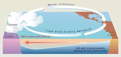
In turn, it has turbo-charged the Pacific trade winds, which have amplified California’s epic drought and accelerated sea level rise by three times in the Western Pacific Ocean.
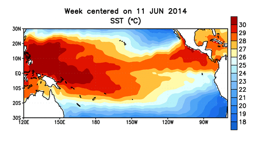
Here is
a NOAA animation of those "9 degrees above average" Pacific waters --
the well-spring of El Niño's -- dissipating into what may turn out to be yet-another "non event."
Here's another look at what those "turbo-charged trade winds" have been doing to the El Niño equatorial well-springs, but from a "section view" perspective, from below the sea:
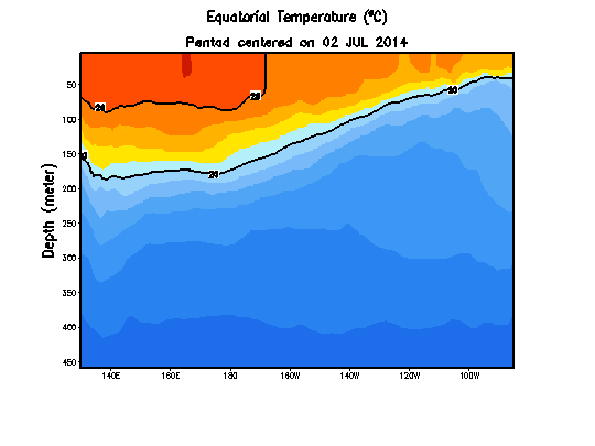
Those trade winds seem to breaking-up or "bulldozing" that pool of warm water -- pushing it back to the far west ... (Far East?) And I would guess that El Niño storm formations don't take kindly to being bull-dozed by consistent trade winds ... (especially considering the last few years of 'failed El Niño predictions') ...
Atlantic Warming Turbocharges Pacific Trade Winds
by Jenna Iacurci, natureworldnews.com -- Aug 04, 2013
Rapid warming of the Atlantic Ocean, likely caused by global warming, has turbocharged Pacific Equatorial trade winds to a level never-before-seen, according to new research.
The increase in these winds has caused eastern tropical Pacific cooling, amplified the Californian drought, accelerated sea level rise three times faster than the global average in the Western Pacific and has slowed the rise of global average surface temperatures since 2001.
[...]
This study found that warming of the Atlantic Ocean was at the heart of the matter, creating unexpected pressure differences between the Atlantic and Pacific.
"The enormous pressure see-saw with high pressure in the Pacific and low pressure in the Atlantic gave the Pacific trade winds an extra kick, amplifying their strength. It's like giving a playground roundabout an extra push as it spins past," explained co-author Axel Timmermann of the University of Hawaii.
[...]
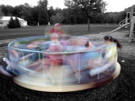 [Image Source: Spinning Roundabout -- yearn2earncash.com]
... when and where it will stop ... does anybody know?
Or as that study published in Nature Climate Change puts it, in somewhat more technical terms ...
[...] Here we analyse a series of climate model experiments along with observational data to show that the recent warming trend in Atlantic sea surface temperature and the corresponding trans-basin displacements of the main atmospheric pressure centres were key drivers of the observed Walker circulation intensification, eastern Pacific cooling, North American rainfall trends and western Pacific sea-level rise. Our study suggests that global surface warming has been partly offset by the Pacific climate response to enhanced Atlantic warming since the early 1990s.
 larger
 --
[Image Source: The Walker Cell -- Southwest Climate Change Network]
Or as we used to say back in the Midwest, back in the 70's:
"You know, what goes around, comes around ... and usually when you least expect it."
Warm the Atlantic waters well above "normal," and take away the normal "rainy season" rains from the eastern Pacific basin (ie. California).
Who knew? (except for some scientist guy named "Walker" of course.)
And now add Axel Timmermann and his science associates, to the list of those in-the-climate-know.

