California is wet and disheveled. Our recent storms included rain, snow, and wind that brought floods, mudslides, avalanches and an end to drought for the northern 42 percent of the state. Waterfalls flowed up into the air. Rivers surged out of their beds; trees uprooted (including a famous sequoia with a tunnel through the trunk); roads slumped away; boulders danced down slopes onto highways; snow piled up as high as the tops of ski lifts; blizzard conditions closed all passes through the Sierras; and some areas had power outages that lasted for days. We were beneath atmospheric rivers. The last was a type known as The Pineapple Express.
 A NASA animation shows the atmospheric river's rainfall over California and the West Coast from Jan. 7 to Jan. 10. Whiter areas have more precipitation, for example Mammoth Mountain in the southern Sierras had 15 feet of new snow.
Credit: Joshua Stevens/NASA Earth Observatory
I remember rainstorms back in the 1900’s when we didn’t use these dramatic labels and weren’t warned accurately ahead of time. We knew it rained like hell because the creeks flooded and our driveways became white-capped rivers. Afterwards we heard how many inches of rain fell, or how many feet of snow. We knew to be prepared without any fancy warnings.
When rainy season began we took out wet season gear — boots, rain pants and jackets, plus big-brimmed plastic hats. We made sure firewood was covered; put sandbags in the back of pick-up trucks to improve traction by adding weight; tossed the tire chains into the cab in case we got stuck in mud or snow; and unclogged house gutters. Life went on. I stocked up on Rite-In-The-Rain notebooks and mechanical pencils; bought a new seine for my dipnet; dug out the sampling tray for aquatic inverts; made sure my backpack was waterproof; and tested my hip-waders for leaks. Rain came, sometimes washing out our roads, and we went out and put them back together. We had atmospheric rivers before the term was coined in 1994, and we had Pineapple Expresses that NOAA says “can transport as water vapor up to 15 times the average flow of liquid water at the mouth of the Mississippi River.”
But the past years of drought taught different lessons, made people careless of storms, and a generation grew up dependent on advance warnings and heedless of flood cautions with their AWD cars. Winter of 2016 teased us with drought-endings, and I sang a love song to rain: water spirit feelin’ springin’ ‘round my head. But last year’s El Niño drenchings never manifested and the drought barely budged, especially in the southern half of the state.
This year, though, the rains arrived early and often in the north. Finally in the beginning of 2017 rains spread to the south. Two storms over a January week added to the rainy autumn, producing one of the wettest years on record. And our water year that began October 1st isn’t over. My storm pr0n includes graphs, tables, and maps because data pr0n is also celebratory.
| The Daily Bucket is a place to discuss what you are seeing around you: animals, weather, meteorites, climate, soil, plants, waters. Each note relates your life, your home range, and the patterns spinning life around us. To have the Daily Bucket in your Activity Stream, visit Backyard Science’s profile page and click on Follow. Phenology is how we take earth’s pulse describes how to write a Bucket of your observations. |
We were warned. National Weather Service told us when the rains would begin and mostly they were accurate to the hour. The public safety agencies distributed sandbags and reminded us to not drive through flooded roadways. (Still people did and had to be rescued. Last week some dude stranded his Hummer in a flooded road in Santa Rosa and had to be airlifted to safety.) Flood watches and blizzard warnings were issued and in many areas floods and blizzards actually happened. We were hammered by precipitation heavier than seen in over a decade, along with strong winds that gusted 160 mph in the high Sierra passes. The storms were so amazing we needed two Twitter hashtags to share storm pr0n: #CAstorm and #CAflood. Facebook posts kept us entertained with videos of gushing creeks spilling over their banks and warnings of road closures. The lowlands and valleys flooded, I-5 was closed for over 100 miles in northern California to Orgeon due to white-out conditions, and all the routes through the Sierras were closed by wash-outs, mud-slides, flood or snow.
The photo of the Yuba River below is near Grass Valley (just south of me). The top map of preciptation levels says this area has had 205 percent of normal rainfall.
After the storms ended last Wednesday I toured a few areas to gawk at flood plains and lazy creeks that had turned into torrents. On my way home, I passed the sign reporting the status of the small reservoir that is my town’s water supply — 112 percent capacity. We have a Facebook group to share photos and stories of local storm outcomes and rain was the main topic of conversation all week. Weather has become interesting and important; it’s no longer chitchat small talk. Climatologists say that no specific storm can be attributed to climate change, but that a pattern of fewer, stronger storms is a consequence of warming temperatures and other climate change features.
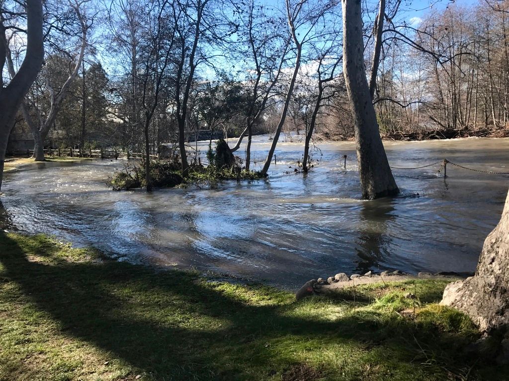 Big Chico Creek grew BIG. Normally the creek begins beyond the chain fence and ends about six feet into the water from the far bank. Plus it’s about a third this deep or less. This is looking downstream. (Photo by Besame)
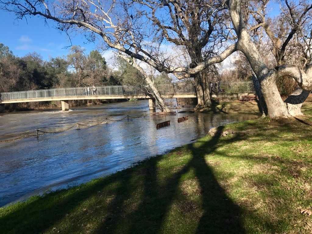 Photo taken from same location as previous one — Big Chico Creek looking upstream. Benches in center are well above the usual water level that is below the chain fence. Usually twice as much of the bridge’s piers are visible. (Photo by Besame)
Dams held back as much water as possible in reservoirs to prevent flooding but even with all the water management infrastructure the state has developed in the last century, areas flooded and others were threatened by levee breaches. Some residents in the Napa and Sacramento valleys were flooded out of their homes. The Sacramento River hit flood stage in the north end of the Central Valley first and then next the Cosumnes River. The Merced River flushed out Yosemite Valley after everyone evacuated. For the first time in over a decade the weirs were opened to allow the Sac River to flow into the Yolo and Sutter bypasses, a measure developed to prevent the once-common flooding of the city Sacramento where the America and Sacramento rivers join.
Not just the Sacramento River hit flood stage, but also other the rivers that flow into it from the Sierras (e.g., Yuba River, Big Chico and Butte creeks shown above). The American River is dammed to form Folsom Lake in the foothills east of the city of Sacramento. In 24 hours, Folsom gained over 60,000 acre feet with 140,000 cubic feet of water per second entering the lake. Note that the photos below aren’t of Folsom Lake (it’s much bigger).
In the San Francisco Bay area, as elsewhere, flooding, mudslides and uprooted trees blocked roads.
Near me, water tends to keep moving downhill as I live on a sloping ridge that is the watershed divide between two major drainages. One drainage is Butte Creek (shown in the lead image above) and the other is the deep narrow West Fork Feather River (no photos of this, too steep!). The North Branch of the Feather River flows through the Highway 70 canyon and usually is 10 to 20 feet or more below the road level. The highway was closed several days during the storms due to landslides, flooding, or snow (at the eastern end higher elevation).
This seasonal waterfall formed during the storm below my town where the ridge edge drops into the Central Valley. The strong winds made the water flow into the sky.
Higher in the Sierras, blizzards closed highways and avalanches moved into homes. Even after the main roads like I-80 were opened, it wasn’t safe driving. This truck driver on I-80’s downslope from Truckee towards Reno displays a thrilling skill and coordination with CHP. It’s made even more amazing at the dramatic ending (wait for it).
Alpine County near Tahoe lived up to its name. This video shows a natural avalance.
A controlled avalance in the same area came in Sigg’s front door.
Tahoe had too much snow for the ski resorts to open. This is the TOP of the ski lift.
A few weeks ago, hydrologists worried that the drought would cause Mono Lake to decrease to the low water level dangerous for wildlife and this would mean Sierra Nevada water cannot be diverted to Los Angeles. They said a wetter than average winter was the only hope for continued exports of water. Last week, Mono was revived by heavy rains and snows.
So, whew, we had enough rain and snowpack to end the drought in the Bay area and the northern part of the state. The maps below show October 2016 before last year’s rains began on the left; center is January 2017 before this recent storm; and on the far right, January 11th after this atmospheric river. The recent rainfall was enough to change the drought status of the San Joaquin Valley, southern Sierras, and most of the Los Angeles area from the dark red highest drought status (catastrophic) to “just” severe or less. The only area with catastrophic drought is between LA and Santa Barbara. Governor Jerry Brown hasn’t declared the drought over yet (he issued the declaration in January 2014) and will wait until the end of winter snow season.
More storms are predicted for the upcoming week. To make room for new inflows to reservoirs the dams are releasing additional water into the downstream rivers. For example, the 770 foot high Oroville dam planned to increase releases from from 5,000 cubic feet per seconds (cfs) to 13,300 cfs thus raising the downstream Feather River two to five feet, depending on the location. One day later, they increased releases to 20,000 cfs. Lake Oroville behind the dam rose 35 feet last weekend and over 95 feet in the past month. This coming week reservoirs might need the water storage space as we begin the warnings and alerts all over again because a new atmospheric river may arrive Wednesday.
We are grateful for everyone who helped during the last storms, such as CalTrans and local crews who opened the roads as fast as possible, and emergency responders like the fire fighters who rescued people trapped in floods.
Even cats were rescued although Harvey doesn’t look ready to celebrate.
But, the frogs are happy!
[Red-legged frogs] start to breed after large rainfall during late winter. They can travel more than two miles during the breeding season. Once they reach their breeding ponds - female California red-legged frogs can lay up to 4,000 eggs at once! Photo by Zach Behrens/National Park Service
I’ve omitted many areas involved in this storm — north coast, russian river, most of southern california. do you have storm stories or pr0n photos to share?
let’s talk about weather — it’s the new sexy.
| "SPOTLIGHT ON GREEN NEWS & VIEWS" IS POSTED EVERY SATURDAY AND WEDNESDAY AFTERNOONS PACIFIC TIME ON THE DAILY KOS FRONT PAGE. IT'S A GREAT WAY TO CATCH UP ON DIARIES YOU MIGHT HAVE MISSED. |


