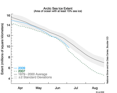
Well, as I alluded to yesterday, the monthly report on Arctic sea ice was issued (backdated to 6 July) by the National Snow and Ice Data Center (NSIDC) from out in Boulder, CO. It opens with a paragraph on the mean sea ice extent for the month; the sea ice concentration for most of the month of June at 2 standard deviations (SD) below normal (for the statistically impaired, this means there's only a 2.1% chance for a one-tailed test of the sea ice concentration being that much below normal by chance). The NSIDC graphic below is basically the same one I showed in my last diary, but with the ±2 SD band in gray added.
More below the jump.
The mean June 2009 Arctic sea ice extent was 11.48 million square kilometers, about 2/3 of the way between the monthly mean concentration and the record minimum, which occurred not in the record minimum extent season of 2007, but the year before, 2006.
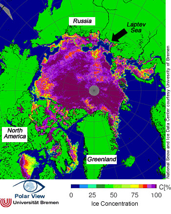
Concentration summary shows that sea ice mostly melted from the Laptev Sea north of Siberian Russia. This happened in 2007, but not in 2008 (see comparisons two graphics down).
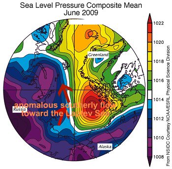
Anomalous winds once again were the reason; southerly flow resulting from an anomalous high over the western hemisphere Arctic and low pressure north of European Russia.
Comparisons to 2008 and 2007
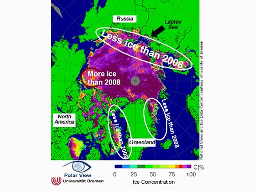
Below you find a repeat of the concentration graphic above, but annotated with differences in sea ice concentration from the prior year, 2008. There are only a couple of areas where sea ice this year is more extensive than last, those being a relatively small portion of the Arctic Ocean north of the Canadian Northwest Territories and west of the Canadian Archipelago, and in parts of Hudson Bay (unmarked). Note that the ice in these locations this year is likely breaking up quickly now, as concentrations vary considerably over short distances in those areas. Much of the Arctic Ocean north of the Eurasian continent has less ice this year than last, as does the Davis Strait. This is in spite of certain inlets with east-facing coastline on Davis Strait being clogged with ice considerably longer than normal, such as in Iqaluit, the main port for the Canadian Archipelago (h/t JohnnyGunn from last diary).
As was the case last year, much of this ice is young, relatively thin ice. We've talked about the impact of this in previous diaries by me and by others. For a quick report on the implications of loss of multiyear sea ice, see this from ArsTechnica, based on an article from Geophysical Research Letters.
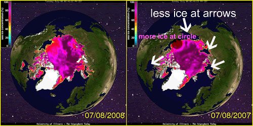
If we compare 2008 and 2007 left to right for 6 July (below), we find that there was less ice in the areas pointed out in the right hand frame with white arrows, and more ice in 2007 only in the area north of the Northwest Territories, indicated by the shaded circle. It can be argued that qualitatively, 2009 looks more like 2007 than 2008. And given the ice is younger at this time in 2009 than in 2007, there may be significant implications for significant sea ice loss for the remainder of the season.
The wild cards will be the short range weather and climate, including an El Niño that has now officially begun, and the seasonal race between ice melt and the setting of the Arctic sun, to begin the long polar night.
